
National Land Cover Database 2001 (NLCD01)
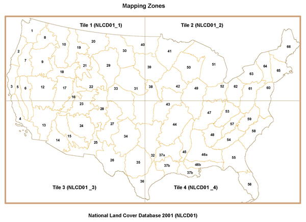
This 30-meter data set represents land use and land cover for the conterminous United States for the 2001 time period. The data have been arranged into four tiles to facilitate timely display and manipulation within a Geographic Information System (see http://water.usgs.gov/GIS/browse/nlcd01-partition.jpg). The National Land Cover Data Set for 2001 was produced through a cooperative project conducted by the Multi-Resolution Land Characteristics (MRLC) Consortium. The MRLC Consortium is a partnership of Federal agencies (http://www.mrlc.gov), consisting of the U.S. Geological Survey (USGS), the National Oceanic and Atmospheric Administration (NOAA), the U.S. Environmental Protection Agency (USEPA), the U.S. Department of Agriculture (USDA), the U.S. Forest Service (USFS), the National Park Service (NPS), the U.S. Fish and Wildlife Service (USFWS), the Bureau of Land Management (BLM), and the USDA Natural Resources Conservation Service (NRCS). One of the primary goals of the project is to generate a current, consistent, seamless, and accurate National Land Cover Database (NLCD) circa 2001 for the United States at medium spatial resolution. For a detailed definition and discussion on MRLC and the NLCD 2001 products, refer to Homer and others (2004), (see: http://www.mrlc.gov/mrlc2k.asp). The NLCD 2001 was created by partitioning the United States into mapping zones. A total of 68 mapping zones (see http://water.usgs.gov/GIS/browse/nlcd01-mappingzones.jpg), were delineated within the conterminous United States based on ecoregion and geographical characteristics, edge-matching features, and the size requirement of Landsat mosaics. Mapping zones encompass the whole or parts of several states. Questions about the NLCD mapping zones can be directed to the NLCD 2001 Land Cover Mapping Team at the USGS/EROS, Sioux Falls, SD (605) 594-6151 or mrlc@usgs.gov.
Citation Information
| Publication Year | 2016 |
|---|---|
| Title | National Land Cover Database 2001 (NLCD01) |
| DOI | 10.3133/ds383 |
| Authors | Andrew E. LaMotte |
| Publication Type | Report |
| Publication Subtype | USGS Numbered Series |
| Series Title | Data Series |
| Series Number | 383 |
| Index ID | ds383 |
| Record Source | USGS Publications Warehouse |
| USGS Organization | Maryland Water Science Center |