An official website of the United States government
Here's how you know
Official websites use .gov
A .gov website belongs to an official government organization in the United States.
Secure .gov websites use HTTPS
A lock () or https:// means you’ve safely connected to the .gov website. Share sensitive information only on official, secure websites.
Encompassing over 175 million acres, America’s “Sagebrush Sea” is the largest terrestrial ecosystem in the lower 48 states. A predominately shrubland system, this landscape ranges over deserts, valleys, mountains, and mesas from the Canadian border to our southwestern deserts. The sagebrush ecosystem – the ancestral homeland of many Tribal Nations – supports critical agricultural and recreation economies of western states and provides habitat to 350 native wildlife species including greater sage-grouse, migratory songbirds, and big game herds.
Large, intense wildfires contributes to the loss of sagebrush habitats.
Yet this vital landscape is at significant risk. A 2022 U.S Geological Survey report found an average of 1.3 million acres of sagebrush have been lost or degraded each year over the last 20 years.
The impacts of climate change, wildfire, and invasive annual grasses, coupled with impacts from human activity, threatens the ability of sagebrush landscapes to sustain biological, economic, and cultural values. Loss of sagebrush landscapes, including the loss of important native grasses and forbs, is driven largely by invasive annual grasses and the associated impacts from large wildfires, resulting in landscape scale change that can be difficult to restore. Complex interactions with drought and changing climates and limited native plant material make restoration challenging and requires a strategic approach to ensure the ecosystem can support wildlife, ranching, recreation, and other land uses.
In response to this unprecedented and accelerating decline, the Department of the Interior’s bureaus, in partnership with the Western Association of Fish and Wildlife Agencies and other partners developed the Sagebrush Conservation Design (SCD), a range-wide, spatially explicit tool to identify the remaining healthy, intact sagebrush core landscapes and opportunities for their growth. The analysis allows for efforts to prioritize, target, and assess strategic investments to ensure restoration actions are working to increase the resilience of the ecosystem at scales meaningful to its long-term sustainability. The 'Defend the Core; Grow the Core' approach, underpinned by the SCD, is at the heart of the Department's efforts to optimize restoration investments in a strategic way across bureaus to arrest the decline of sagebrush landscapes.
Sagebrush Collaborative Restoration Landscapes
The Department's Sagebrush Landscape Collaborative is working across bureaus to guide strategic restoration investments, catalyze coordination, and drive meaningful outcomes to improve resiliency to fire and drought. Through the Bipartisan Infrastructure Law and the Inflation Reduction Act, the Department is implementing a more than $2 billion down payment to restore our nation’s lands and waters. This framework will help ensure that investments from these two laws are focused strategically to solve key conservation challenges and advance climate resilience.
Sagebrush Collaborative Restoration Landscapes capture over a third of the remaining intact Core Sagebrush Areas across the sagebrush biome.
The Sagebrush Landscapes Collaborative worked with partners to identify five Sagebrush Collaborative Restoration Landscapes across the sagebrush ecosystem for long-term strategic investments to defend and grow sagebrush core habitat. Collectively, these landscapes include about a third of all remaining sagebrush core habitat according to the range-wide analysis of the SCD.
Sagebrush Collaborative Restoration Landscapes represent places where the Department can take non-regulatory actions to co-invest funding across its bureaus and offices, building upon existing partnerships to collectively target restoration actions. DOI is seeking to enhance ongoing collaboration with public and private partners and further focus current efforts in these landscapes to address primary threats to sagebrush ecosystem health.
Sagebrush Collaborative Restoration Landscapes were delineated using watershed boundaries with publicly available information to ensure these areas have high ecological value now and durability in the future with respect to climate resilience, and where existing collaborations have capacity to deliver on-the-ground actions. Input was also solicited from federal and state resources agencies and Tribes to refine where restoration priorities existed. Information utilized includes:
Existing state and federal management designations for areas of high value for wildlife, habitat, and migratory corridors: and
Where on-the-ground actions will have more durability under future climate scenarios.
Each Sagebrush Collaborative Restoration Landscape is briefly described below:
Oregon and Nevada Sagebrush Collaborative Restoration Landscape
This landscape is primarily located in southeast Oregon and northwest Nevada and is anchored around the expansive Hart Mountain Antelope and Sheldon National Wildlife Refuges, and the surrounding sagebrush ecosystems that also includes the BLM Restoration Landscape in Southeast Oregon and Nevada Montana Mountains. This landscape includes over 5.4 million acres of ‘Core Sagebrush’ and ‘Growth Opportunity’ Areas.
Sagebrush Collaborative Restoration Landscapes capture over a third of the remaining intact Core Sagebrush Areas across the sagebrush biome. This landscape is primarily located in southeast Oregon and northwest Nevada and is anchored around the expansive Hart Mountain Antelope and Sheldon National Wildlife Refuges, and the surrounding sagebrush ecosystems that also includes the BLM Restoration...
Idaho and Southwest Montana Sagebrush Collaborative Restoration Landscape
This landscape in Idaho and southwestern Montana is anchored around Craters of the Moon National Monument and Preserve, stretching west to the Snake River Plain and northeast to Upper Salmon River and Missouri River headwaters sagebrush country in the High Divide region along the Idaho-Montana state line. This landscape includes portions of four BLM Restoration Landscapes and over 6.4 million acres of ‘Core Sagebrush’ and ‘Growth Opportunity’ Areas.
Sagebrush Collaborative Restoration Landscapes capture over a third of the remaining intact Core Sagebrush Areas across the sagebrush biome. This landscape in Idaho and southwestern Montana is anchored around Craters of the Moon National Monument and Preserve, stretching west to the Snake River Plain and northeast to Upper Salmon River and Missouri River headwaters sagebrush country in the High...
This landscape is located in north central Montana and is anchored around the Charles M. Russell National Wildlife Refuge and BLM’s ‘Hi-Line Sagebrush Anchor’ Restoration Landscape. This landscape includes over 3.3 million acres of ‘Core Sagebrush’ and ‘Growth Opportunity’ Areas.
Sagebrush Collaborative Restoration Landscapes capture over a third of the remaining intact Core Sagebrush Areas across the sagebrush biome. This landscape is located in north central Montana and is anchored around the Charles M. Russell National Wildlife Refuge and BLM’s ‘Hi-Line Sagebrush Anchor’ Restoration Landscape. This landscape includes over 3.3 million acres of ‘Core Sagebrush’ and...
Wyoming and Northeast Utah Sagebrush Collaborative Restoration Landscape
This landscape covers portions of southwest Wyoming and northeast Utah, anchored in the Upper Green River Basin and the Upper Bear River Watershed. The landscape also includes the high elevation Red Desert region of south-central Wyoming and intersects with the BLM’s Muddy Creek, La Barge, and Upper Bear River Restoration Landscapes. This landscape includes over 7.9 million acres of ‘Core Sagebrush’ and ‘Growth Opportunity’ Areas.
Sagebrush Collaborative Restoration Landscapes capture over a third of the remaining intact Core Sagebrush Areas across the sagebrush biome. This landscape covers portions of southwest Wyoming and northeast Utah, anchored in the Upper Green River Basin and the Upper Bear River Watershed. The landscape also includes the high elevation Red Desert region of south-central Wyoming and intersects with...
This landscape spans the Gunnison Basin of southwestern Colorado, including Black Canyon of the Gunnison National Park and Curecanti National Recreation Area. This landscape includes more than 400,000 acres of ‘Core Sagebrush’ and ‘Growth Opportunity’ Areas.
Sagebrush Collaborative Restoration Landscapes capture over a third of the remaining intact Core Sagebrush Areas across the sagebrush biome. This landscape spans the Gunnison Basin of southwestern Colorado, including Black Canyon of the Gunnison National Park and Curecanti National Recreation Area. This landscape includes more than 400,000 acres of ‘Core Sagebrush’ and ‘Growth Opportunity’ Areas...
Encompassing over 175 million acres, America’s “Sagebrush Sea” is the largest terrestrial ecosystem in the lower 48 states. A predominately shrubland system, this landscape ranges over deserts, valleys, mountains, and mesas from the Canadian border to our southwestern deserts. The sagebrush ecosystem – the ancestral homeland of many Tribal Nations – supports critical agricultural and recreation economies of western states and provides habitat to 350 native wildlife species including greater sage-grouse, migratory songbirds, and big game herds.
Large, intense wildfires contributes to the loss of sagebrush habitats.
Yet this vital landscape is at significant risk. A 2022 U.S Geological Survey report found an average of 1.3 million acres of sagebrush have been lost or degraded each year over the last 20 years.
The impacts of climate change, wildfire, and invasive annual grasses, coupled with impacts from human activity, threatens the ability of sagebrush landscapes to sustain biological, economic, and cultural values. Loss of sagebrush landscapes, including the loss of important native grasses and forbs, is driven largely by invasive annual grasses and the associated impacts from large wildfires, resulting in landscape scale change that can be difficult to restore. Complex interactions with drought and changing climates and limited native plant material make restoration challenging and requires a strategic approach to ensure the ecosystem can support wildlife, ranching, recreation, and other land uses.
In response to this unprecedented and accelerating decline, the Department of the Interior’s bureaus, in partnership with the Western Association of Fish and Wildlife Agencies and other partners developed the Sagebrush Conservation Design (SCD), a range-wide, spatially explicit tool to identify the remaining healthy, intact sagebrush core landscapes and opportunities for their growth. The analysis allows for efforts to prioritize, target, and assess strategic investments to ensure restoration actions are working to increase the resilience of the ecosystem at scales meaningful to its long-term sustainability. The 'Defend the Core; Grow the Core' approach, underpinned by the SCD, is at the heart of the Department's efforts to optimize restoration investments in a strategic way across bureaus to arrest the decline of sagebrush landscapes.
Sagebrush Collaborative Restoration Landscapes
The Department's Sagebrush Landscape Collaborative is working across bureaus to guide strategic restoration investments, catalyze coordination, and drive meaningful outcomes to improve resiliency to fire and drought. Through the Bipartisan Infrastructure Law and the Inflation Reduction Act, the Department is implementing a more than $2 billion down payment to restore our nation’s lands and waters. This framework will help ensure that investments from these two laws are focused strategically to solve key conservation challenges and advance climate resilience.
Sagebrush Collaborative Restoration Landscapes capture over a third of the remaining intact Core Sagebrush Areas across the sagebrush biome.
The Sagebrush Landscapes Collaborative worked with partners to identify five Sagebrush Collaborative Restoration Landscapes across the sagebrush ecosystem for long-term strategic investments to defend and grow sagebrush core habitat. Collectively, these landscapes include about a third of all remaining sagebrush core habitat according to the range-wide analysis of the SCD.
Sagebrush Collaborative Restoration Landscapes represent places where the Department can take non-regulatory actions to co-invest funding across its bureaus and offices, building upon existing partnerships to collectively target restoration actions. DOI is seeking to enhance ongoing collaboration with public and private partners and further focus current efforts in these landscapes to address primary threats to sagebrush ecosystem health.
Sagebrush Collaborative Restoration Landscapes were delineated using watershed boundaries with publicly available information to ensure these areas have high ecological value now and durability in the future with respect to climate resilience, and where existing collaborations have capacity to deliver on-the-ground actions. Input was also solicited from federal and state resources agencies and Tribes to refine where restoration priorities existed. Information utilized includes:
Existing state and federal management designations for areas of high value for wildlife, habitat, and migratory corridors: and
Where on-the-ground actions will have more durability under future climate scenarios.
Each Sagebrush Collaborative Restoration Landscape is briefly described below:
Oregon and Nevada Sagebrush Collaborative Restoration Landscape
This landscape is primarily located in southeast Oregon and northwest Nevada and is anchored around the expansive Hart Mountain Antelope and Sheldon National Wildlife Refuges, and the surrounding sagebrush ecosystems that also includes the BLM Restoration Landscape in Southeast Oregon and Nevada Montana Mountains. This landscape includes over 5.4 million acres of ‘Core Sagebrush’ and ‘Growth Opportunity’ Areas.
Sagebrush Collaborative Restoration Landscapes capture over a third of the remaining intact Core Sagebrush Areas across the sagebrush biome. This landscape is primarily located in southeast Oregon and northwest Nevada and is anchored around the expansive Hart Mountain Antelope and Sheldon National Wildlife Refuges, and the surrounding sagebrush ecosystems that also includes the BLM Restoration...
Idaho and Southwest Montana Sagebrush Collaborative Restoration Landscape
This landscape in Idaho and southwestern Montana is anchored around Craters of the Moon National Monument and Preserve, stretching west to the Snake River Plain and northeast to Upper Salmon River and Missouri River headwaters sagebrush country in the High Divide region along the Idaho-Montana state line. This landscape includes portions of four BLM Restoration Landscapes and over 6.4 million acres of ‘Core Sagebrush’ and ‘Growth Opportunity’ Areas.
Sagebrush Collaborative Restoration Landscapes capture over a third of the remaining intact Core Sagebrush Areas across the sagebrush biome. This landscape in Idaho and southwestern Montana is anchored around Craters of the Moon National Monument and Preserve, stretching west to the Snake River Plain and northeast to Upper Salmon River and Missouri River headwaters sagebrush country in the High...
This landscape is located in north central Montana and is anchored around the Charles M. Russell National Wildlife Refuge and BLM’s ‘Hi-Line Sagebrush Anchor’ Restoration Landscape. This landscape includes over 3.3 million acres of ‘Core Sagebrush’ and ‘Growth Opportunity’ Areas.
Sagebrush Collaborative Restoration Landscapes capture over a third of the remaining intact Core Sagebrush Areas across the sagebrush biome. This landscape is located in north central Montana and is anchored around the Charles M. Russell National Wildlife Refuge and BLM’s ‘Hi-Line Sagebrush Anchor’ Restoration Landscape. This landscape includes over 3.3 million acres of ‘Core Sagebrush’ and...
Wyoming and Northeast Utah Sagebrush Collaborative Restoration Landscape
This landscape covers portions of southwest Wyoming and northeast Utah, anchored in the Upper Green River Basin and the Upper Bear River Watershed. The landscape also includes the high elevation Red Desert region of south-central Wyoming and intersects with the BLM’s Muddy Creek, La Barge, and Upper Bear River Restoration Landscapes. This landscape includes over 7.9 million acres of ‘Core Sagebrush’ and ‘Growth Opportunity’ Areas.
Sagebrush Collaborative Restoration Landscapes capture over a third of the remaining intact Core Sagebrush Areas across the sagebrush biome. This landscape covers portions of southwest Wyoming and northeast Utah, anchored in the Upper Green River Basin and the Upper Bear River Watershed. The landscape also includes the high elevation Red Desert region of south-central Wyoming and intersects with...
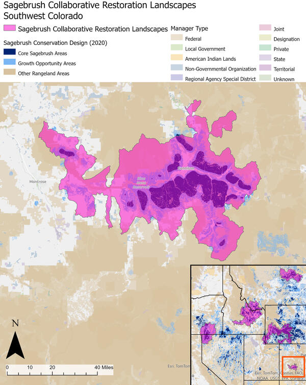
This landscape spans the Gunnison Basin of southwestern Colorado, including Black Canyon of the Gunnison National Park and Curecanti National Recreation Area. This landscape includes more than 400,000 acres of ‘Core Sagebrush’ and ‘Growth Opportunity’ Areas.
Sagebrush Collaborative Restoration Landscapes capture over a third of the remaining intact Core Sagebrush Areas across the sagebrush biome. This landscape spans the Gunnison Basin of southwestern Colorado, including Black Canyon of the Gunnison National Park and Curecanti National Recreation Area. This landscape includes more than 400,000 acres of ‘Core Sagebrush’ and ‘Growth Opportunity’ Areas...