
USGS researchers (GLSC; Ann Arbor, Michigan) partner with the Monterey Bay Aquarium Research Institute to launch the Triton Long Range Autonomous Underwater Vehicle (LRAUV) in Lake Huron near Cheboygan, Michigan.
Alden T Tilley
Alden Tilley is a Biological Science Technician based in Ann Arbor, MI.
Science and Products
Multimedia by this scientist
AUV Staging
USGS researchers (GLSC; Ann Arbor, Michigan) partner with the Monterey Bay Aquarium Research Institute to launch the Triton Long Range Autonomous Underwater Vehicle (LRAUV) in Lake Huron near Cheboygan, Michigan.

Toronto at Sunset from Humber Bay
Toronto's skyline at sunset from Humber Bay in Lake Ontario. Photo credit: Alden Tilley, USGS.
Toronto's skyline at sunset from Humber Bay in Lake Ontario. Photo credit: Alden Tilley, USGS.

AUV in Porte des Morts
USGS scientists (GLSC; Ann Arbor, Michigna) prepare to launch an autonomous underwater vehicle from the GLSC’s R/V Dragonfly in Porte des Morts within the Lake Michigan waters of Wisconsin. Photo credit: Alden Tilley, USGS.
USGS scientists (GLSC; Ann Arbor, Michigna) prepare to launch an autonomous underwater vehicle from the GLSC’s R/V Dragonfly in Porte des Morts within the Lake Michigan waters of Wisconsin. Photo credit: Alden Tilley, USGS.

Sauble Falls Provincial Park
Sauble Falls in Sauble Falls Provincial Park, Ontario, Canada. Photo credit: Alden Tilley, USGS.
Sauble Falls in Sauble Falls Provincial Park, Ontario, Canada. Photo credit: Alden Tilley, USGS.

Little Dunks Bay
Little Dunks Bay, Lake Huron, at the tip of the Bruce Peninsula in Ontario, Canada. Photo credit: Alden Tilley, USGS.
Little Dunks Bay, Lake Huron, at the tip of the Bruce Peninsula in Ontario, Canada. Photo credit: Alden Tilley, USGS.

Waterfall at Pictured Rocks National Lakeshore
A waterfall flowing into Lake Superior along Pictured Rocks National Lakeshore. Photo credit: Alden Tilley, USGS.
A waterfall flowing into Lake Superior along Pictured Rocks National Lakeshore. Photo credit: Alden Tilley, USGS.

Reef Mapping in Progress
USGS biological science technicians (GLSC; Ann Arbor, Michigan) aboard the R/V Desmid mapping Manistique Rocky Shoal in Lake Michigan. Photo credit: Alden Tilley, USGS.
USGS biological science technicians (GLSC; Ann Arbor, Michigan) aboard the R/V Desmid mapping Manistique Rocky Shoal in Lake Michigan. Photo credit: Alden Tilley, USGS.

Burbot at Night
A burbot (Lota lota) between rocks illuminated by a dive light at night, in Lake Superior. Photo credit: Alden Tilley, USGS.
A burbot (Lota lota) between rocks illuminated by a dive light at night, in Lake Superior. Photo credit: Alden Tilley, USGS.

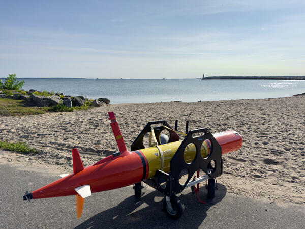
LRAUV Preparing for Shore Launch
The Monterey Bay Aquarium Research Institute’s Long Range Autonomous Underwater Vehicle (LRAUV) on the beach in Muskegon, Michigan, prior to being launched into Lake Michigan for a mission with USGS scientists. Photo credit: Alden Tilley, USGS.
The Monterey Bay Aquarium Research Institute’s Long Range Autonomous Underwater Vehicle (LRAUV) on the beach in Muskegon, Michigan, prior to being launched into Lake Michigan for a mission with USGS scientists. Photo credit: Alden Tilley, USGS.

Sunrise on the Keweenaw Peninsula
The sun rising over Lake Superior near Gay, Michigan on the Keweenaw Peninsula. Photo credit: Alden Tilley, USGS.
The sun rising over Lake Superior near Gay, Michigan on the Keweenaw Peninsula. Photo credit: Alden Tilley, USGS.
Science and Products
Multimedia by this scientist
AUV Staging
USGS researchers (GLSC; Ann Arbor, Michigan) partner with the Monterey Bay Aquarium Research Institute to launch the Triton Long Range Autonomous Underwater Vehicle (LRAUV) in Lake Huron near Cheboygan, Michigan.
USGS researchers (GLSC; Ann Arbor, Michigan) partner with the Monterey Bay Aquarium Research Institute to launch the Triton Long Range Autonomous Underwater Vehicle (LRAUV) in Lake Huron near Cheboygan, Michigan.
Toronto at Sunset from Humber Bay
Toronto's skyline at sunset from Humber Bay in Lake Ontario. Photo credit: Alden Tilley, USGS.
Toronto's skyline at sunset from Humber Bay in Lake Ontario. Photo credit: Alden Tilley, USGS.
AUV in Porte des Morts
USGS scientists (GLSC; Ann Arbor, Michigna) prepare to launch an autonomous underwater vehicle from the GLSC’s R/V Dragonfly in Porte des Morts within the Lake Michigan waters of Wisconsin. Photo credit: Alden Tilley, USGS.
USGS scientists (GLSC; Ann Arbor, Michigna) prepare to launch an autonomous underwater vehicle from the GLSC’s R/V Dragonfly in Porte des Morts within the Lake Michigan waters of Wisconsin. Photo credit: Alden Tilley, USGS.
Sauble Falls Provincial Park
Sauble Falls in Sauble Falls Provincial Park, Ontario, Canada. Photo credit: Alden Tilley, USGS.
Sauble Falls in Sauble Falls Provincial Park, Ontario, Canada. Photo credit: Alden Tilley, USGS.
Little Dunks Bay
Little Dunks Bay, Lake Huron, at the tip of the Bruce Peninsula in Ontario, Canada. Photo credit: Alden Tilley, USGS.
Little Dunks Bay, Lake Huron, at the tip of the Bruce Peninsula in Ontario, Canada. Photo credit: Alden Tilley, USGS.
Waterfall at Pictured Rocks National Lakeshore
A waterfall flowing into Lake Superior along Pictured Rocks National Lakeshore. Photo credit: Alden Tilley, USGS.
A waterfall flowing into Lake Superior along Pictured Rocks National Lakeshore. Photo credit: Alden Tilley, USGS.
Reef Mapping in Progress
USGS biological science technicians (GLSC; Ann Arbor, Michigan) aboard the R/V Desmid mapping Manistique Rocky Shoal in Lake Michigan. Photo credit: Alden Tilley, USGS.
USGS biological science technicians (GLSC; Ann Arbor, Michigan) aboard the R/V Desmid mapping Manistique Rocky Shoal in Lake Michigan. Photo credit: Alden Tilley, USGS.
Burbot at Night
A burbot (Lota lota) between rocks illuminated by a dive light at night, in Lake Superior. Photo credit: Alden Tilley, USGS.
A burbot (Lota lota) between rocks illuminated by a dive light at night, in Lake Superior. Photo credit: Alden Tilley, USGS.
LRAUV Preparing for Shore Launch
The Monterey Bay Aquarium Research Institute’s Long Range Autonomous Underwater Vehicle (LRAUV) on the beach in Muskegon, Michigan, prior to being launched into Lake Michigan for a mission with USGS scientists. Photo credit: Alden Tilley, USGS.
The Monterey Bay Aquarium Research Institute’s Long Range Autonomous Underwater Vehicle (LRAUV) on the beach in Muskegon, Michigan, prior to being launched into Lake Michigan for a mission with USGS scientists. Photo credit: Alden Tilley, USGS.
Sunrise on the Keweenaw Peninsula
The sun rising over Lake Superior near Gay, Michigan on the Keweenaw Peninsula. Photo credit: Alden Tilley, USGS.
The sun rising over Lake Superior near Gay, Michigan on the Keweenaw Peninsula. Photo credit: Alden Tilley, USGS.