An official website of the United States government
Here's how you know
Official websites use .gov
A .gov website belongs to an official government organization in the United States.
Secure .gov websites use HTTPS
A lock () or https:// means you’ve safely connected to the .gov website. Share sensitive information only on official, secure websites.
Kīlauea's summit eruption continues on the Island of Hawai‘i; the west vent in Halema‘uma‘u erupts lava into the lava lake. Gas emissions and seismic activity at the summit remain elevated. HVO field crews—equipped with specialized safety gear and PPE—monitor the current eruption from within the closed area of Hawai&lsq
HVO scientists collect detailed data to assess hazards and understand how the eruption is evolving at Kīlauea's summit, all of which are shared with the National Park Service and emergency managers. Access to this hazardous area is by permission from, and in coordination with, Hawai‘i Volcanoes National Park.
The ongoing eruption at Kīlauea Volcano’s summit, within Halema‘uma‘u crater, continues to erupt from the west vent (left). Yesterday evening, January 4, the lava lake was measured at approximately 191 m (626 ft) deep. No major changes have been observed over the past week. HVO scientists continue to monitor the eruption within an area of Hawai‘i Volcanoes National Park that remains closed to the public for safety reasons. View is looking to the north. USGS photo taken by M. Patrick on January 4 at 6:08 p.m. HST.
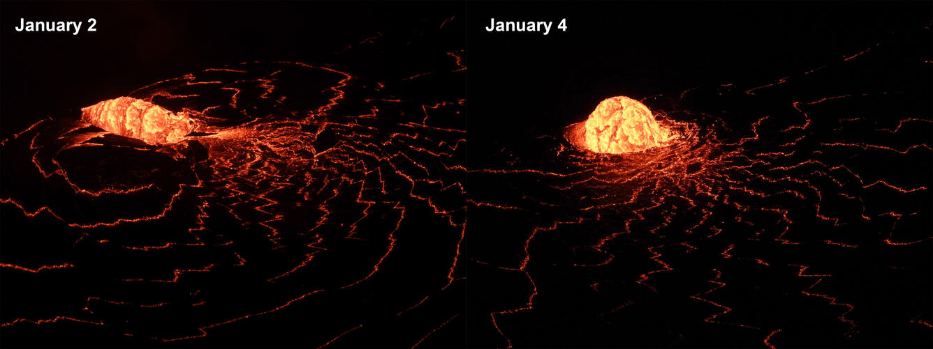
The eruption from the west vent in Halema‘uma‘u crater continues at Kīlauea’s summit. Nighttime telephoto images from January 2 (left) and January 4 (right) compare the recent changes in the dome fountain at the west vent inlet into the lava lake. By January 4, the small dome fountain is more uniform and less elongated. USGS photos by M. Patrick.
At approximately 8:00 a.m. HST this morning there was a small breakout from the lower part of the west vent tube. This telephoto aerial photograph taken at about 8:30 a.m. HST during a HVO overflight of Halema‘uma‘u crater, shows the newly exposed lava channel entering the lava lake. Lava also continues to enter the lava lake through the tube, which is producing the small dome fountain at the lake margin below (lower center). USGS photo taken by B. Carr on January 5, 2021.
Aerial thermal image taken at approximately 8:30 a.m. HST during this morning’s HVO overflight. The “perched” lava lake geometry has become much more apparent over the past week as the cooler perimeter of the lava lake widens. See this photo for a description on how the perched lava lake forms. View looking northwest. USGS thermal image taken by M. Patrick on January 5, 2021.
Watch the changes in the growing lava lake within Halema'uma'u crater in these thermal maps from December 21-30, 2020.In the first thermal map (December 21, 2020), the lake area is about 33 acres. In the last thermal map (December 30, 2020), the lake is about 82 acres. The dimensions of the lava lake are now 875 yd on the E-W axis (7+ football fields) and 580 yd on the N-S axis. In the center of the lake, is a 7-acre raft/island (blue color) that rises above the surrounding lake surface by 20-26 ft. The raft moves with lake currents and is likely material erupted early in this eruption that accumulated at the base of Halema‘uma‘u crater. In addition to the raft/island there are ~10 or so small islands visible on the east end of the lake.The scale of the thermal map ranges from blue to red, with blue colors indicative of cooler temperatures and red colors indicative of warmer temperatures. The western fissures and [now submerged] northern fissures are red in color. A blue rim is visible along the lake margin beginning December 26. This is a narrow ledge of cooled lava (a "bathtub ring") about 1-2 yards above the lava lake surface.Hawaiian Volcano Observatory scientists conduct periodic helicopter overflights of Halema'uma'u crater to acquire visual and thermal imagery during this eruption. Imagery is used to create maps and assess hazards. USGS maps by M. Patrick.
Kīlauea Volcano, U.S. Geological Survey Hawaiian Volcano Observatory timelapse of thermal imagery showing Halema‘uma‘u west vents and lava entering the lava lake. This timelapse was taken over one hour, between approximately 10 and 11 p.m on December 29, 2020.
These videos show an increase in the surface activity where lava is entering the lake. Clip 1: Lava from Halema‘uma‘u west vents entering the lava lake on December 31, 2020, at approximately 10 a.m. HST.Clip 2: Lava from Halema‘uma‘u west vents entering the lava lake on January 2, 2021, at approximately 11 p.m. HST.Kīlauea Volcano, U.S. Geological Survey Hawaiian Volcano Observatory. More at usgs.gov/hvo.
Videos of the eruption and lava lake in Halema‘uma‘u on January 1, 2021.Clip 1: Halema‘uma‘u west vents and lava entering the lava lake at approximately 5:30 p.m. HST.Clip 2: Telephoto view of lava from Halema‘uma‘u west vents entering the lava lake at approximately 5 p.m. HST.Clip 3: The lava lake overflows onto a lower edge along the north margin at approximately 3:30 p.m. HST.Visit U.S. Geological Survey Hawaiian Volcano Observatory.
Lava forms a “dome fountain” at the inlet to the lava lake in Halema'uma'u crater January 2-3, 2021. Lava from the western vent cascades beneath roofed vertical channels to enter the lava lake at an inlet that has become partially submerged. The result is a rolling upwelling of lava near the inlet called a “dome fountain.”Dome fountains have been observed during eruptions at Mauna Ulu and Pu‘u ‘Ō‘ō. Dome fountains can occur when lava rapidly emerges from a constricted vent or fissure onto the surface or, as in this case, beneath the surface of a lava lake. The feature resembles, in part, a bubbling water fountain. The height of the dome fountain was estimated to be about 5 m (16 ft) with an estimated width of 10 m (33 ft).