An official website of the United States government
Here's how you know
Official websites use .gov
A .gov website belongs to an official government organization in the United States.
Secure .gov websites use HTTPS
A lock () or https:// means you’ve safely connected to the .gov website. Share sensitive information only on official, secure websites.
Braided section of the lava channel located "downstream" between about 3.5 to 6 km (2.2 to 3.7 mi) from fissure 8 (upper right). The width of the two channels in the middle center is about 325 m (1,065 ft). View is toward the southwest.
Fissure 8 (lower right) and open lava channel leading to the northeast. Geologists noted small lava-level fluctuations in the open channel overnight, which indicates intermittent variations in lava discharge from fissure 8. An increase in lava levels was noted about 1.5 hours after the collapse-explosion event at the volcano's summit at 02:55 a.m. HST. Evidence of a couple of recent, short-lived channel overflows were observed early this morning, but they had not reached the edge of the flow field. The small steam plumes in distance mark locations of fissures that erupted in early May at the beginning of the ongoing eruption.
View of the partially filled Kapoho Crater (center) and the open lava channel where it makes a 90-degree turn around the crater. The open channel no longer directly enters the ocean. Lava flows freely through the channel only to the southern edge of Kapoho Crater (left side of image). Clearly, lava moves into and through the molten core of the thick ‘a‘ā flow across a broad area from both the sides and end of the channel.
Multiple ocean entries were active this early morning, each contributing to the prominent "laze" plume above the area. Lava moves from the open channel through the molten core of the broad ‘a‘ā flow field to the ocean. Kapoho Crater is at middle right of photo.
Lava still oozes from the northern edge of the ‘a‘ā flow near the lighthouse at Cape Kumukahi (upper right). Smoke from burning vegetation marks location of lava oozeouts. View is toward the northeast.
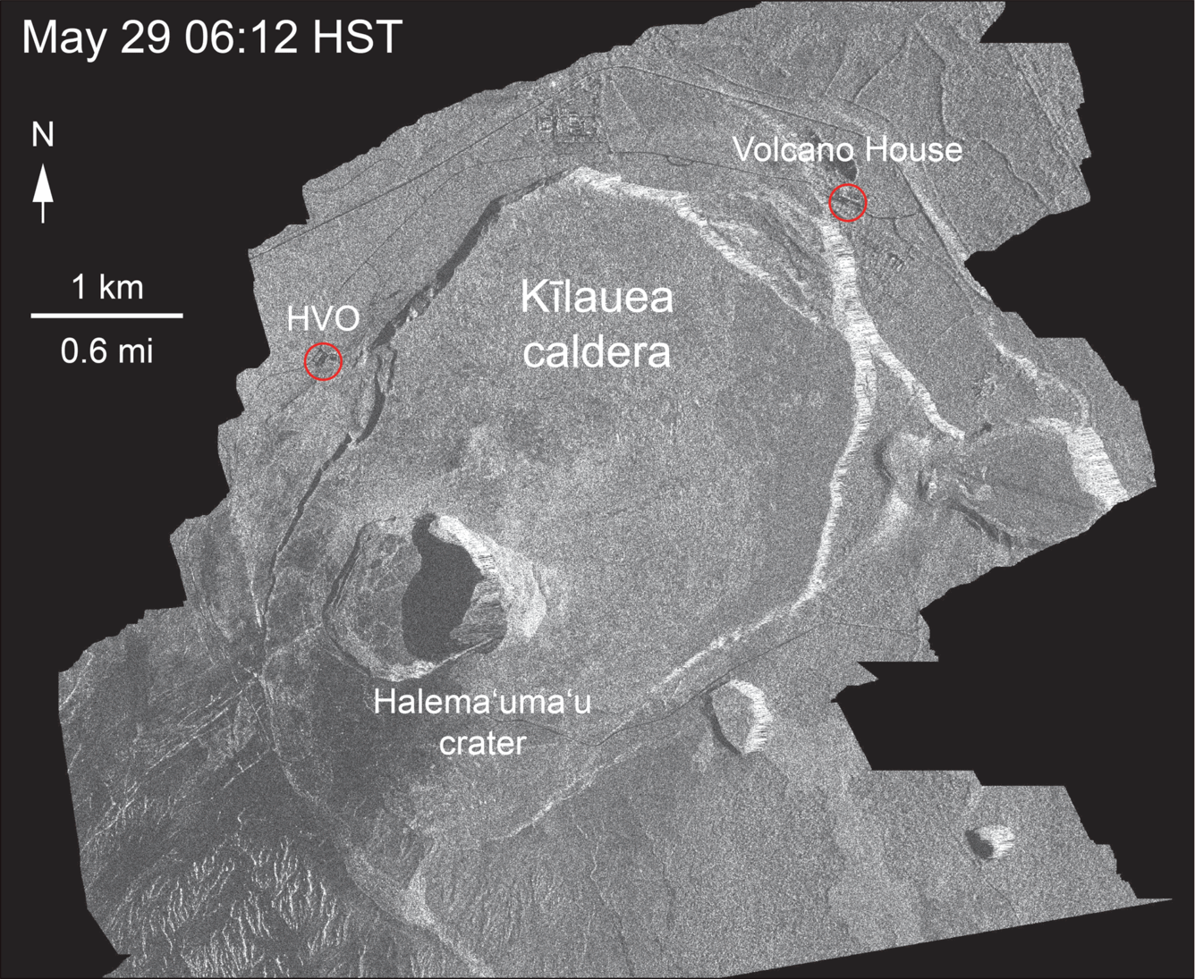
This animated GIF shows a sequence of radar amplitude images that were acquired by the Agenzia Spaziale Italiana CosmoSkyMed satellite system. The images illustrate changes to the caldera area of Kīlauea Volcano that occurred between May 5 and July 8 at about 6:00 a.m. HST. The satellite transmits a radar signal at the surface and measures the strength of the return, with bright areas indicating a strong return and dark areas a weak return. Strong returns indicate rough surfaces or slopes that point back at the radar, while weak returns come from smooth surfaces or slopes angled away from the radar. Over time, expansion of the summit eruptive vent within Halema'uma'u crater and the widening of Halema'uma'u itself are obvious. Starting in late May, the development of several cracks outside Halema'uma'u is clear, and inward slumping of a large portion of the western, southwestern, and northern crater rim begins. Much of this motion appears to be coincident with the small explosions from the summit that have taken place on a near daily basis since early June. The most recent radar scene, from July 8, shows continued motion along cracks over a broader area of the caldera floor, extending east of Halema'uma'u (these cracks are the scarps seen in recent photographs from the Keanakākoʻi overlook area). We expect this slumping to continue as long as the collapse events and overall subsidence persist.