Past Year Monitoring Data for Kīlauea Active
This page presents Kīlauea monitoring data collected over the past year, including earthquake rates, locations, and depths, ground deformation data, and gas data.
Seismic Data
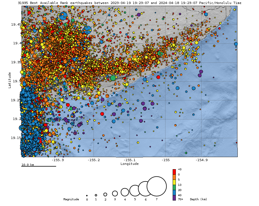
Earthquake Hypocenters Map and Cross Section - Past Year

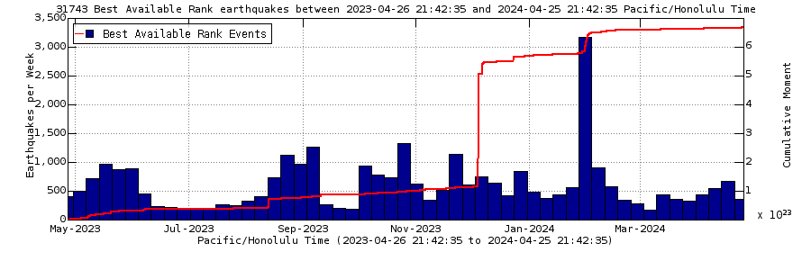
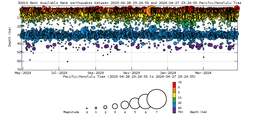
Earthquake Rates and Depths - Past Year

Deformation Data
Map of Selected Deformation Stations
For more information on how electronic tiltmeters and GPS receivers help monitor the deformation of Kīlauea Volcano, see the HVO Deformation page. Data plots from additional stations are available from our interactive map. Use the right-side menu to view different types of data.
Global Positioning System - Past Year
Kīlauea Summit
Pu‘u‘ō‘ō Cone
Gas Data
Sulfur dioxide emission rates - Kīlauea summit - past year

- Overview
This page presents Kīlauea monitoring data collected over the past year, including earthquake rates, locations, and depths, ground deformation data, and gas data.
Seismic Data
Earthquake Hypocenters Map and Cross Section - Past Year
Remote image Url Sources/Usage: Public Domain. View Media DetailsRemote image Url
 Sources/Usage: Public Domain. View Media Details
Above Top: Map showing locations of earthquakes during the past year. Bottom: Depth of earthquakes (circles) during the past year. Depth is reported relative to sea level, which is equal to a depth of zero on the above plot. Circle-size represents magnitude, and color indicates depth. An interactive earthquake plot can be found on the HVO Earthquakes page. Earthquake Rates and Depths - Past Year
Remote image Url Sources/Usage: Public Domain. View Media DetailsRemote image Url
 Sources/Usage: Public Domain. View Media Details
Above Top: Number of earthquakes per week during the past year (blue bars). The red line is the cumulative moment (energy) release. Bottom: Depth of earthquakes during the past year in the area shown on the map above. Depth is reported relative to sea level, which is equal to a depth of zero on the above plot. On both figures, circle-size represents magnitude, and color indicates depth. An interactive earthquake plot can be found on the HVO Earthquakes page.  Sources/Usage: Public Domain. View Media Details
Select deformation instuments located on Kīlauea Volcano. (Public domain.) Deformation Data
Map of Selected Deformation Stations
For more information on how electronic tiltmeters and GPS receivers help monitor the deformation of Kīlauea Volcano, see the HVO Deformation page. Data plots from additional stations are available from our interactive map. Use the right-side menu to view different types of data.
Global Positioning System - Past Year
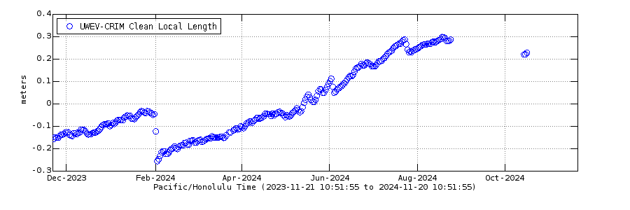
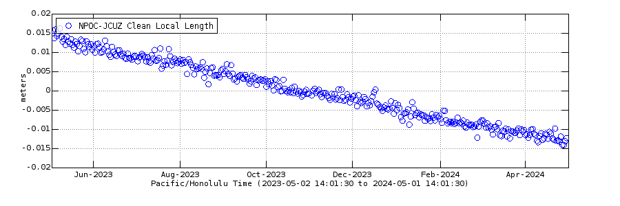
Kīlauea Summit
Remote image Url Sources/Usage: Public Domain. View Media Details
Change in distance between two Global Positioning System (GPS) stations located on opposite sides of Kīlauea's caldera. A rapid increase in distance can be interpreted as inflation of the summit magma reservoir or Pu‘u‘ō‘ō magma storage chamber. Pu‘u‘ō‘ō Cone
Remote image Url Sources/Usage: Public Domain. View Media Details
Change in distance between two stations near Pu‘u‘ō‘ō. A rapid increase in distance can be interpreted as inflation of the summit magma reservoir or Pu‘u‘ō‘ō magma storage chamber. Gas Data
Sulfur dioxide emission rates - Kīlauea summit - past year
Remote image Url Sources/Usage: Public Domain. View Media Details
Sulfur dioxide (SO2) emission rates measured using an upward-looking ultraviolet spectrometer. These data are collected by traversing the gas plume in a vehicle or helicopter, downwind of Halema‘uma‘u, generally within and/or southwest of Kīlauea caldera. Results from multiple traverses during a day are averaged to yield the emission rates shown here. Successful measurements depend on wind, weather, and staff availability. Values are preliminary and are subject to revision.

