An official website of the United States government
Here's how you know
Official websites use .gov
A .gov website belongs to an official government organization in the United States.
Secure .gov websites use HTTPS
A lock () or https:// means you’ve safely connected to the .gov website. Share sensitive information only on official, secure websites.
This photograph of Kīlauea's middle East Rift Zone eruption was captured during a Hawaiian Volcano Observatory helicopter overflight during the morning of September 17, 2024. Geologists observed fountaining eruptive fissures and active lava flows on the floor of Nāpau Crater, just downrift (northeast) of the September 15 eruptive fissure. This south-facing view shows the current activity from the north side of Nāpau Crater. USGS photo by A. Ellis.
Magma intruded beneath the ground near Makaopuhi Crater—a well-known magma storage region on Kīlauea’s middle East Rift Zone on September 14. HVO published a Status Report alerting the public and partners to the activity, which was accompanied by hundreds of earthquakes and ground deformation.
PHASE 1: a brief eruption occurred west of Nāpau Crater on the middle East Rift Zone between 9 and 10 p.m. HST on September 15. 2024. Infrasound sensors in HVO’s monitoring network recorded strong signals indicative of gas or steam venting. At the same time, HVO’s seismometers recorded weak but sustained low frequency tremor. Although an eruption could not be confirmed visually Sunday night by webcams or satellite thermal data due to heavy rainfall, the geophysical data indicated that an eruption could be taking place. That night, some residents in nearby communities also reported strong sulfur or burning smells. The alert level and aviation color code for Kīlauea is raised to ORANGE/WATCH. During an overflight the next morning, geologists observed that a 480-meter (1600-foot) long fissure had covered 16,500 square meters (4 acres) with about 20,000 cubic meters (about 5 million gallons) of lava. Lava was no longer flowing on the surface as of Monday, but magma was still moving underground as detected by seismometers, tiltmeters and GPS.
PHASE 2: NOAA GOES satellite thermal imagery and HVO webcam imagery detect that the eruption has resumed around 6 p.m. HST on September 16. Interestingly, no changes were detected in other monitoring datasets. Fissures from this phase of the eruption produced lava fountains and flows that gradually decreased through the night. But activity would soon resume.
USGS Hawaiian Volcano Observatory geologists conducted a reconnaissance overflight of the eruption near Nāpau Crater on the middle East Rift Zone of Kīlauea on September 19, 2024. They observed lava cascading over the rim of the crater from a channel more than 50 meters (about 164 feet) wide. Lava was contained within Nāpau Crater and covered about two thirds of the crater floor. USGS photo by M. Zoeller.
PHASE 3: Between 4 and 5 a.m. HST September 17, infrasound signals, a GOES satellite thermal anomaly, and webcam imagery indicated that the eruption had resumed. After sunrise, HVO scientists on a helicopter overflight observed new vents had opened in Nāpau Crater, with several lava fountains approximately 10 meters (yards) high generating lava flows on the floor of Nāpau Crater. This eruptive phase was more vigorous, l longer lived and continued at gradually decreasing levels through Wednesday afternoon. In total, the fissure system has stretched over 1.6 kilometers (1.0 miles) of the East Rift Zone, with lava flows now covering 18 hectares (44 acres).
PHASE 4: At 3:15 p.m. HST, on September 18, new eruptive fissures opened west of Nāpau Crater. A monitoring camera deployed by HVO field crews with permission from Hawaiʻi Volcanoes National Park recorded “lava falls” cascading down the northwest walls of Nāpau Crater. Vigorous activity continued and by the morning of September 19, about 2/3 of Nāpau Crater floor had been covered with new lava. As of 10 a.m. HST on September 20 morning, phase 4 eruptive activity had ended.
October 4, 2024 — Reference map of September 2024 Kīlauea middle East Rift Zone eruption
This reference map depicts the final state of the Kīlauea middle East Rift Zone eruption that occurred between September 15 and 20, 2024. The eruptive fissures stretched along 1.8 kilometers (1.1 miles) of the East Rift Zone, with the longest lava flow extending 1.4 kilometers (0.9 miles) from the main eruptive vent, which was situated west of Nāpau Crater.
This reference map depicts the final state of the Kīlauea middle East Rift Zone eruption that occurred between September 15 and 20, 2024. The eruptive fissures stretched along 1.8 kilometers (1.1 miles) of the East Rift Zone, with the longest lava flow extending 1.4 kilometers (0.9 miles) from the main eruptive vent, which was situated west of Nāpau Crater.
September 20, 2024 — Thermal map of eruption on Kīlauea East Rift Zone
A helicopter overflight on September 20, 2024, allowed for aerial visual and thermal imagery to be collected at the middle East Rift Zone eruption site on Kīlauea. This thermal map shows that the eruption at Nāpau Crater had paused this morning, with no fountaining or active lava on the surface.
A helicopter overflight on September 20, 2024, allowed for aerial visual and thermal imagery to be collected at the middle East Rift Zone eruption site on Kīlauea. This thermal map shows that the eruption at Nāpau Crater had paused this morning, with no fountaining or active lava on the surface.
September 20, 2024—Ground cracks in the middle East Rift Zone of Kīlauea
On September 20, 2024, USGS Hawaiian Volcano Observatory geologists examined a ground crack near the recent eruption site in the remote middle East Rift Zone of Kīlauea. USGS photo by M. Patrick.
On September 20, 2024, USGS Hawaiian Volcano Observatory geologists examined a ground crack near the recent eruption site in the remote middle East Rift Zone of Kīlauea. USGS photo by M. Patrick.
September 20, 2024 —Kīlauea middle East Rift Zone eruption summary
On the night of September 15, USGS Hawaiian Volcano Observatory geophysical data indicated that an eruption could be occurring a remote area of Kīlauea’s middle East Rift Zone, within Hawaiʻi Volcanoes National Park.
On the night of September 15, USGS Hawaiian Volcano Observatory geophysical data indicated that an eruption could be occurring a remote area of Kīlauea’s middle East Rift Zone, within Hawaiʻi Volcanoes National Park.
September 20, 2024—Lava flows on the floor of Nāpau Crater, Kīlauea middle East Rift Zone
A view across the floor of Nāpau Crater, covered with fresh lava flows. In the background of the photo, which faces northwest, lava flows that recently cascaded over the northwest wall of the crater are visible. USGS photo by M. Patrick.
A view across the floor of Nāpau Crater, covered with fresh lava flows. In the background of the photo, which faces northwest, lava flows that recently cascaded over the northwest wall of the crater are visible. USGS photo by M. Patrick.
September 20, 2024—Kīlauea middle East Rift Zone recent lava flows
Pāhoehoe lava flows paved the floor of Nāpau Crater during the recent eruption on Kīlauea middle East Rift Zone. Pāhoehoe is characterized by smooth, billowy, and ropy surface textures. Recent lava flowed over tephra that previously coated this area of the crater floor.
Pāhoehoe lava flows paved the floor of Nāpau Crater during the recent eruption on Kīlauea middle East Rift Zone. Pāhoehoe is characterized by smooth, billowy, and ropy surface textures. Recent lava flowed over tephra that previously coated this area of the crater floor.
September 20, 2024—Kīlauea middle East Rift Zone eruption western fissure reactivation
A telephoto view of the fissure that briefly reactivated west of Nāpau Crater this morning, September 20. Low-level fountaining occurred from approximately 8–9:30 a.m. HST. USGS photo by H. Winslow.
A telephoto view of the fissure that briefly reactivated west of Nāpau Crater this morning, September 20. Low-level fountaining occurred from approximately 8–9:30 a.m. HST. USGS photo by H. Winslow.
September 20, 2024—Kīlauea middle East Rift Zone eruption overview
During the September 20 monitoring overflight, USGS Hawaiin Volcano Observatory geologists observed the fissure west of Nāpau Crater reactivate briefly between 8–9:30 a.m. HST, with minor fissure fountaining and lava flows. View is looking southeast. USGS photo by H. Winslow.
During the September 20 monitoring overflight, USGS Hawaiin Volcano Observatory geologists observed the fissure west of Nāpau Crater reactivate briefly between 8–9:30 a.m. HST, with minor fissure fountaining and lava flows. View is looking southeast. USGS photo by H. Winslow.
September 20, 2024 — Measuring gas emissions from Kīlauea eruption
USGS Hawaiian Volcano Observatory gas scientists measured the composition of gases being emitted by Kīlauea during the waning phase of the middle East Rift Zone eruption on September 20, 2024. They used a FTIR spectrometer, which measures how the plume of gases being emitted at the eruption site absorbs infrared energy.
USGS Hawaiian Volcano Observatory gas scientists measured the composition of gases being emitted by Kīlauea during the waning phase of the middle East Rift Zone eruption on September 20, 2024. They used a FTIR spectrometer, which measures how the plume of gases being emitted at the eruption site absorbs infrared energy.
September 20, 2024—Lava flows from recent Kīlauea middle East Rift Zone eruption cover Nāpau Trail
From the floor of Nāpau Crater, USGS Hawaiian Volcano Observatory geologists observed where recent lava flows covered the trail in the crater. The trail is visible in the lower center portion of the photograph, as a track in tephra deposited during previous eruptions in the area. USGS photo by M. Patrick.
From the floor of Nāpau Crater, USGS Hawaiian Volcano Observatory geologists observed where recent lava flows covered the trail in the crater. The trail is visible in the lower center portion of the photograph, as a track in tephra deposited during previous eruptions in the area. USGS photo by M. Patrick.
September 20, 2024—Kīlauea middle East Rift Zone eruption spatter
USGS Hawaiian Volcano Observatory field crews reported small fountains and lava flows erupting from one of the western fissures just before 9 a.m. HST on September 20, 2024. By 10 a.m. HST, that activity had ceased and the middle East Rift Zone eruption of Kīlauea had paused. USGS photo by M. Patrick.
USGS Hawaiian Volcano Observatory field crews reported small fountains and lava flows erupting from one of the western fissures just before 9 a.m. HST on September 20, 2024. By 10 a.m. HST, that activity had ceased and the middle East Rift Zone eruption of Kīlauea had paused. USGS photo by M. Patrick.
September 20, 2024—Kīlauea middle East Rift Zone eruption aerial view of fuming vent
USGS Hawaiian Volcano Observatory field monitoring crews reported minor spattering and small fountains at one end of the vent as of 8:30 a.m. HST on September 20, 2024. By 10 a.m. HST, eruptive activity had paused but the eruptive vents continued to emit volcanic gas and steam, visible in this aerial photograph.
USGS Hawaiian Volcano Observatory field monitoring crews reported minor spattering and small fountains at one end of the vent as of 8:30 a.m. HST on September 20, 2024. By 10 a.m. HST, eruptive activity had paused but the eruptive vents continued to emit volcanic gas and steam, visible in this aerial photograph.
September 20, 2024—Kīlauea middle East Rift Zone eruption overview
This image, captured during a UGSS Hawaiian Volcano Observatory monitoring overflight the morning of September 20, 2024, shows that most of Nāpau Crater floor has been covered with new lava during the recent Kīlauea middle East Rift Zone eruption. USGS photo by M. Patrick.
This image, captured during a UGSS Hawaiian Volcano Observatory monitoring overflight the morning of September 20, 2024, shows that most of Nāpau Crater floor has been covered with new lava during the recent Kīlauea middle East Rift Zone eruption. USGS photo by M. Patrick.
September 20, 2024—Kīlauea middle East Rift Zone eruption overflight and ground views
USGS Hawaiian Volcano Observatory field monitoring crews captured these videos during their visit to Kīlauea middle East Rift Zone eruption site the morning of September 20, 2024. They reported minor spattering and small fountains at one end of the vent at 8:30 a.m. HST. By 10 a.m.
USGS Hawaiian Volcano Observatory field monitoring crews captured these videos during their visit to Kīlauea middle East Rift Zone eruption site the morning of September 20, 2024. They reported minor spattering and small fountains at one end of the vent at 8:30 a.m. HST. By 10 a.m.
September 19, 2024—New lava flows on the middle East Rift Zone of Kīlauea
On September 19, 2024, USGS-Hawaiian Volcano Observatory geologists landed near the Kīlauea middle East Rift Zone eruption site, where they viewed lava flowing through a channel more than 50 meters (about 164 feet) wide.
On September 19, 2024, USGS-Hawaiian Volcano Observatory geologists landed near the Kīlauea middle East Rift Zone eruption site, where they viewed lava flowing through a channel more than 50 meters (about 164 feet) wide.
September 19, 2024 —Kīlauea middle East Rift Zone eruption overflight
The 150-m-long (nearly 500 feet) fissure erupting west of Nāpau Crater within Hawaʻi Volcanoes National Park began erupting yesterday, September 18, around 3:15 p.m. It's part of an eruptive sequence that began in this area the night of September 15, 2024.
The 150-m-long (nearly 500 feet) fissure erupting west of Nāpau Crater within Hawaʻi Volcanoes National Park began erupting yesterday, September 18, around 3:15 p.m. It's part of an eruptive sequence that began in this area the night of September 15, 2024.
September 19, 2024 —Kīlauea middle East Rift Zone eruption aerial views
USGS Hawaiian Volcano Observatory geologists conducted a reconnaissance overflight of the eruption near Nāpau Crater on the middle East Rift Zone of Kīlauea. They observed a 150-m-long (nearly 500 feet) fissure west of the crater erupting lava that is flowing in the crater via a channel more than 50 meters (about 164 feet) wide.
USGS Hawaiian Volcano Observatory geologists conducted a reconnaissance overflight of the eruption near Nāpau Crater on the middle East Rift Zone of Kīlauea. They observed a 150-m-long (nearly 500 feet) fissure west of the crater erupting lava that is flowing in the crater via a channel more than 50 meters (about 164 feet) wide.
September 19, 2024 —Kīlauea middle East Rift Zone eruption overflight
During the USGS Hawaiian Volcano Observatory reconnaissance overflight the morning of September 19, geologists observed the fissure west of Nāpau Crater generating a lava flow that travels northeast before cascading into the crater on the remote middle East Rift Zone of Kīlauea. This aerial view is looking in a south direction, from north of the eruption site.
During the USGS Hawaiian Volcano Observatory reconnaissance overflight the morning of September 19, geologists observed the fissure west of Nāpau Crater generating a lava flow that travels northeast before cascading into the crater on the remote middle East Rift Zone of Kīlauea. This aerial view is looking in a south direction, from north of the eruption site.
September 19, 2024 — Kīlauea middle East Rift Zone eruption overflight
USGS Hawaiian Volcano Observatory geologists conducted a reconnaissance overflight of the eruption near Nāpau Crater on the middle East Rift Zone of Kīlauea. They observed lava cascading over the rim of the crater from a channel more than 50 meters (about 164 feet) wide.
USGS Hawaiian Volcano Observatory geologists conducted a reconnaissance overflight of the eruption near Nāpau Crater on the middle East Rift Zone of Kīlauea. They observed lava cascading over the rim of the crater from a channel more than 50 meters (about 164 feet) wide.
A new Kīlauea eruption began in a remote area of Hawaiʻi Volcanoes National Park on Sunday, September 15, 2024. This is the first eruption on Kīlauea...
This photograph of Kīlauea's middle East Rift Zone eruption was captured during a Hawaiian Volcano Observatory helicopter overflight during the morning of September 17, 2024. Geologists observed fountaining eruptive fissures and active lava flows on the floor of Nāpau Crater, just downrift (northeast) of the September 15 eruptive fissure. This south-facing view shows the current activity from the north side of Nāpau Crater. USGS photo by A. Ellis.
Magma intruded beneath the ground near Makaopuhi Crater—a well-known magma storage region on Kīlauea’s middle East Rift Zone on September 14. HVO published a Status Report alerting the public and partners to the activity, which was accompanied by hundreds of earthquakes and ground deformation.
PHASE 1: a brief eruption occurred west of Nāpau Crater on the middle East Rift Zone between 9 and 10 p.m. HST on September 15. 2024. Infrasound sensors in HVO’s monitoring network recorded strong signals indicative of gas or steam venting. At the same time, HVO’s seismometers recorded weak but sustained low frequency tremor. Although an eruption could not be confirmed visually Sunday night by webcams or satellite thermal data due to heavy rainfall, the geophysical data indicated that an eruption could be taking place. That night, some residents in nearby communities also reported strong sulfur or burning smells. The alert level and aviation color code for Kīlauea is raised to ORANGE/WATCH. During an overflight the next morning, geologists observed that a 480-meter (1600-foot) long fissure had covered 16,500 square meters (4 acres) with about 20,000 cubic meters (about 5 million gallons) of lava. Lava was no longer flowing on the surface as of Monday, but magma was still moving underground as detected by seismometers, tiltmeters and GPS.
PHASE 2: NOAA GOES satellite thermal imagery and HVO webcam imagery detect that the eruption has resumed around 6 p.m. HST on September 16. Interestingly, no changes were detected in other monitoring datasets. Fissures from this phase of the eruption produced lava fountains and flows that gradually decreased through the night. But activity would soon resume.
USGS Hawaiian Volcano Observatory geologists conducted a reconnaissance overflight of the eruption near Nāpau Crater on the middle East Rift Zone of Kīlauea on September 19, 2024. They observed lava cascading over the rim of the crater from a channel more than 50 meters (about 164 feet) wide. Lava was contained within Nāpau Crater and covered about two thirds of the crater floor. USGS photo by M. Zoeller.
PHASE 3: Between 4 and 5 a.m. HST September 17, infrasound signals, a GOES satellite thermal anomaly, and webcam imagery indicated that the eruption had resumed. After sunrise, HVO scientists on a helicopter overflight observed new vents had opened in Nāpau Crater, with several lava fountains approximately 10 meters (yards) high generating lava flows on the floor of Nāpau Crater. This eruptive phase was more vigorous, l longer lived and continued at gradually decreasing levels through Wednesday afternoon. In total, the fissure system has stretched over 1.6 kilometers (1.0 miles) of the East Rift Zone, with lava flows now covering 18 hectares (44 acres).
PHASE 4: At 3:15 p.m. HST, on September 18, new eruptive fissures opened west of Nāpau Crater. A monitoring camera deployed by HVO field crews with permission from Hawaiʻi Volcanoes National Park recorded “lava falls” cascading down the northwest walls of Nāpau Crater. Vigorous activity continued and by the morning of September 19, about 2/3 of Nāpau Crater floor had been covered with new lava. As of 10 a.m. HST on September 20 morning, phase 4 eruptive activity had ended.
October 4, 2024 — Reference map of September 2024 Kīlauea middle East Rift Zone eruption
This reference map depicts the final state of the Kīlauea middle East Rift Zone eruption that occurred between September 15 and 20, 2024. The eruptive fissures stretched along 1.8 kilometers (1.1 miles) of the East Rift Zone, with the longest lava flow extending 1.4 kilometers (0.9 miles) from the main eruptive vent, which was situated west of Nāpau Crater.
This reference map depicts the final state of the Kīlauea middle East Rift Zone eruption that occurred between September 15 and 20, 2024. The eruptive fissures stretched along 1.8 kilometers (1.1 miles) of the East Rift Zone, with the longest lava flow extending 1.4 kilometers (0.9 miles) from the main eruptive vent, which was situated west of Nāpau Crater.
September 20, 2024 — Thermal map of eruption on Kīlauea East Rift Zone
A helicopter overflight on September 20, 2024, allowed for aerial visual and thermal imagery to be collected at the middle East Rift Zone eruption site on Kīlauea. This thermal map shows that the eruption at Nāpau Crater had paused this morning, with no fountaining or active lava on the surface.
A helicopter overflight on September 20, 2024, allowed for aerial visual and thermal imagery to be collected at the middle East Rift Zone eruption site on Kīlauea. This thermal map shows that the eruption at Nāpau Crater had paused this morning, with no fountaining or active lava on the surface.
September 20, 2024—Ground cracks in the middle East Rift Zone of Kīlauea
On September 20, 2024, USGS Hawaiian Volcano Observatory geologists examined a ground crack near the recent eruption site in the remote middle East Rift Zone of Kīlauea. USGS photo by M. Patrick.
On September 20, 2024, USGS Hawaiian Volcano Observatory geologists examined a ground crack near the recent eruption site in the remote middle East Rift Zone of Kīlauea. USGS photo by M. Patrick.
September 20, 2024 —Kīlauea middle East Rift Zone eruption summary
On the night of September 15, USGS Hawaiian Volcano Observatory geophysical data indicated that an eruption could be occurring a remote area of Kīlauea’s middle East Rift Zone, within Hawaiʻi Volcanoes National Park.
On the night of September 15, USGS Hawaiian Volcano Observatory geophysical data indicated that an eruption could be occurring a remote area of Kīlauea’s middle East Rift Zone, within Hawaiʻi Volcanoes National Park.
September 20, 2024—Lava flows on the floor of Nāpau Crater, Kīlauea middle East Rift Zone
A view across the floor of Nāpau Crater, covered with fresh lava flows. In the background of the photo, which faces northwest, lava flows that recently cascaded over the northwest wall of the crater are visible. USGS photo by M. Patrick.
A view across the floor of Nāpau Crater, covered with fresh lava flows. In the background of the photo, which faces northwest, lava flows that recently cascaded over the northwest wall of the crater are visible. USGS photo by M. Patrick.
September 20, 2024—Kīlauea middle East Rift Zone recent lava flows
Pāhoehoe lava flows paved the floor of Nāpau Crater during the recent eruption on Kīlauea middle East Rift Zone. Pāhoehoe is characterized by smooth, billowy, and ropy surface textures. Recent lava flowed over tephra that previously coated this area of the crater floor.
Pāhoehoe lava flows paved the floor of Nāpau Crater during the recent eruption on Kīlauea middle East Rift Zone. Pāhoehoe is characterized by smooth, billowy, and ropy surface textures. Recent lava flowed over tephra that previously coated this area of the crater floor.
September 20, 2024—Kīlauea middle East Rift Zone eruption western fissure reactivation
A telephoto view of the fissure that briefly reactivated west of Nāpau Crater this morning, September 20. Low-level fountaining occurred from approximately 8–9:30 a.m. HST. USGS photo by H. Winslow.
A telephoto view of the fissure that briefly reactivated west of Nāpau Crater this morning, September 20. Low-level fountaining occurred from approximately 8–9:30 a.m. HST. USGS photo by H. Winslow.
September 20, 2024—Kīlauea middle East Rift Zone eruption overview
During the September 20 monitoring overflight, USGS Hawaiin Volcano Observatory geologists observed the fissure west of Nāpau Crater reactivate briefly between 8–9:30 a.m. HST, with minor fissure fountaining and lava flows. View is looking southeast. USGS photo by H. Winslow.
During the September 20 monitoring overflight, USGS Hawaiin Volcano Observatory geologists observed the fissure west of Nāpau Crater reactivate briefly between 8–9:30 a.m. HST, with minor fissure fountaining and lava flows. View is looking southeast. USGS photo by H. Winslow.
September 20, 2024 — Measuring gas emissions from Kīlauea eruption
USGS Hawaiian Volcano Observatory gas scientists measured the composition of gases being emitted by Kīlauea during the waning phase of the middle East Rift Zone eruption on September 20, 2024. They used a FTIR spectrometer, which measures how the plume of gases being emitted at the eruption site absorbs infrared energy.
USGS Hawaiian Volcano Observatory gas scientists measured the composition of gases being emitted by Kīlauea during the waning phase of the middle East Rift Zone eruption on September 20, 2024. They used a FTIR spectrometer, which measures how the plume of gases being emitted at the eruption site absorbs infrared energy.
September 20, 2024—Lava flows from recent Kīlauea middle East Rift Zone eruption cover Nāpau Trail
From the floor of Nāpau Crater, USGS Hawaiian Volcano Observatory geologists observed where recent lava flows covered the trail in the crater. The trail is visible in the lower center portion of the photograph, as a track in tephra deposited during previous eruptions in the area. USGS photo by M. Patrick.
From the floor of Nāpau Crater, USGS Hawaiian Volcano Observatory geologists observed where recent lava flows covered the trail in the crater. The trail is visible in the lower center portion of the photograph, as a track in tephra deposited during previous eruptions in the area. USGS photo by M. Patrick.
September 20, 2024—Kīlauea middle East Rift Zone eruption spatter
USGS Hawaiian Volcano Observatory field crews reported small fountains and lava flows erupting from one of the western fissures just before 9 a.m. HST on September 20, 2024. By 10 a.m. HST, that activity had ceased and the middle East Rift Zone eruption of Kīlauea had paused. USGS photo by M. Patrick.
USGS Hawaiian Volcano Observatory field crews reported small fountains and lava flows erupting from one of the western fissures just before 9 a.m. HST on September 20, 2024. By 10 a.m. HST, that activity had ceased and the middle East Rift Zone eruption of Kīlauea had paused. USGS photo by M. Patrick.
September 20, 2024—Kīlauea middle East Rift Zone eruption spatter
USGS Hawaiian Volcano Observatory field crews reported small fountains and lava flows erupting from one of the western fissures just before 9 a.m. HST on September 20, 2024. By 10 a.m. HST, that activity had ceased and the middle East Rift Zone eruption of Kīlauea had paused. USGS photo by M. Patrick.
USGS Hawaiian Volcano Observatory field crews reported small fountains and lava flows erupting from one of the western fissures just before 9 a.m. HST on September 20, 2024. By 10 a.m. HST, that activity had ceased and the middle East Rift Zone eruption of Kīlauea had paused. USGS photo by M. Patrick.
September 20, 2024—Kīlauea middle East Rift Zone eruption aerial view of fuming vent
USGS Hawaiian Volcano Observatory field monitoring crews reported minor spattering and small fountains at one end of the vent as of 8:30 a.m. HST on September 20, 2024. By 10 a.m. HST, eruptive activity had paused but the eruptive vents continued to emit volcanic gas and steam, visible in this aerial photograph.
USGS Hawaiian Volcano Observatory field monitoring crews reported minor spattering and small fountains at one end of the vent as of 8:30 a.m. HST on September 20, 2024. By 10 a.m. HST, eruptive activity had paused but the eruptive vents continued to emit volcanic gas and steam, visible in this aerial photograph.
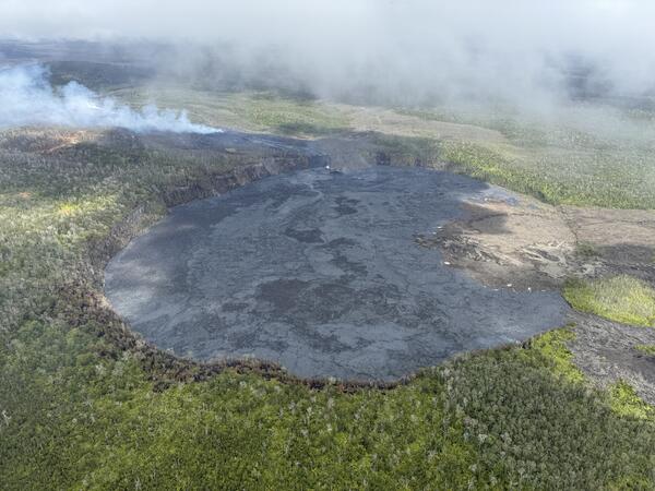
September 20, 2024—Kīlauea middle East Rift Zone eruption overview
This image, captured during a UGSS Hawaiian Volcano Observatory monitoring overflight the morning of September 20, 2024, shows that most of Nāpau Crater floor has been covered with new lava during the recent Kīlauea middle East Rift Zone eruption. USGS photo by M. Patrick.
This image, captured during a UGSS Hawaiian Volcano Observatory monitoring overflight the morning of September 20, 2024, shows that most of Nāpau Crater floor has been covered with new lava during the recent Kīlauea middle East Rift Zone eruption. USGS photo by M. Patrick.
September 20, 2024—Kīlauea middle East Rift Zone eruption overflight and ground views
USGS Hawaiian Volcano Observatory field monitoring crews captured these videos during their visit to Kīlauea middle East Rift Zone eruption site the morning of September 20, 2024. They reported minor spattering and small fountains at one end of the vent at 8:30 a.m. HST. By 10 a.m.
USGS Hawaiian Volcano Observatory field monitoring crews captured these videos during their visit to Kīlauea middle East Rift Zone eruption site the morning of September 20, 2024. They reported minor spattering and small fountains at one end of the vent at 8:30 a.m. HST. By 10 a.m.
September 19, 2024—New lava flows on the middle East Rift Zone of Kīlauea
On September 19, 2024, USGS-Hawaiian Volcano Observatory geologists landed near the Kīlauea middle East Rift Zone eruption site, where they viewed lava flowing through a channel more than 50 meters (about 164 feet) wide.
On September 19, 2024, USGS-Hawaiian Volcano Observatory geologists landed near the Kīlauea middle East Rift Zone eruption site, where they viewed lava flowing through a channel more than 50 meters (about 164 feet) wide.
September 19, 2024 —Kīlauea middle East Rift Zone eruption overflight
The 150-m-long (nearly 500 feet) fissure erupting west of Nāpau Crater within Hawaʻi Volcanoes National Park began erupting yesterday, September 18, around 3:15 p.m. It's part of an eruptive sequence that began in this area the night of September 15, 2024.
The 150-m-long (nearly 500 feet) fissure erupting west of Nāpau Crater within Hawaʻi Volcanoes National Park began erupting yesterday, September 18, around 3:15 p.m. It's part of an eruptive sequence that began in this area the night of September 15, 2024.
September 19, 2024 —Kīlauea middle East Rift Zone eruption aerial views
USGS Hawaiian Volcano Observatory geologists conducted a reconnaissance overflight of the eruption near Nāpau Crater on the middle East Rift Zone of Kīlauea. They observed a 150-m-long (nearly 500 feet) fissure west of the crater erupting lava that is flowing in the crater via a channel more than 50 meters (about 164 feet) wide.
USGS Hawaiian Volcano Observatory geologists conducted a reconnaissance overflight of the eruption near Nāpau Crater on the middle East Rift Zone of Kīlauea. They observed a 150-m-long (nearly 500 feet) fissure west of the crater erupting lava that is flowing in the crater via a channel more than 50 meters (about 164 feet) wide.
September 19, 2024 —Kīlauea middle East Rift Zone eruption overflight
During the USGS Hawaiian Volcano Observatory reconnaissance overflight the morning of September 19, geologists observed the fissure west of Nāpau Crater generating a lava flow that travels northeast before cascading into the crater on the remote middle East Rift Zone of Kīlauea. This aerial view is looking in a south direction, from north of the eruption site.
During the USGS Hawaiian Volcano Observatory reconnaissance overflight the morning of September 19, geologists observed the fissure west of Nāpau Crater generating a lava flow that travels northeast before cascading into the crater on the remote middle East Rift Zone of Kīlauea. This aerial view is looking in a south direction, from north of the eruption site.
September 19, 2024 — Kīlauea middle East Rift Zone eruption overflight
USGS Hawaiian Volcano Observatory geologists conducted a reconnaissance overflight of the eruption near Nāpau Crater on the middle East Rift Zone of Kīlauea. They observed lava cascading over the rim of the crater from a channel more than 50 meters (about 164 feet) wide.
USGS Hawaiian Volcano Observatory geologists conducted a reconnaissance overflight of the eruption near Nāpau Crater on the middle East Rift Zone of Kīlauea. They observed lava cascading over the rim of the crater from a channel more than 50 meters (about 164 feet) wide.
A new Kīlauea eruption began in a remote area of Hawaiʻi Volcanoes National Park on Sunday, September 15, 2024. This is the first eruption on Kīlauea...