
NEW TNMCorps Mapping Challenge for Law Enforcement in KS & OK!
TNMCorps mapping challenges continue in the Midwest with a new challenge for law enforcement features in Kansas and Oklahoma! This is an excellent challenge for Standard Editors and Peer Reviewers with many red and green points that need to be confirmed.
As you can see from the map, this challenge has a decent amount of seed data.
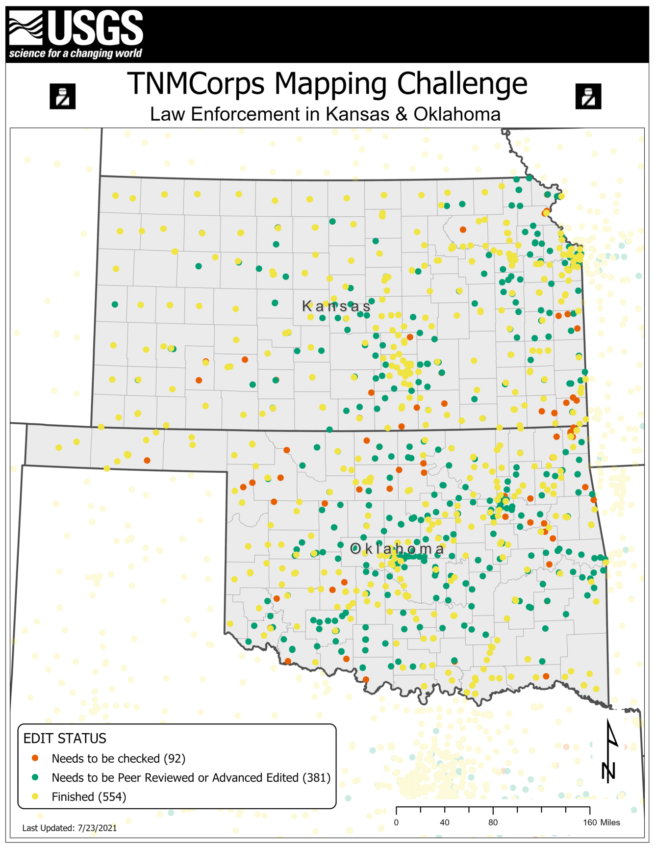
Not sure what each point color means?
These colors are part of our tiered editing process and signal to other editors that a point has passed through the upper tiers and does not need to be edited again. Our November 2018 newsletter has an article titled Editor Roles and Point Colors that describes this process further.

Check for points with no edit history
As you’re searching for points participating in this challenge, don’t forget to check for points with no edit history. If you come across a law enforcement point that’s been edited (i.e., green, blue, purple, or yellow border) but has no edit history, please research the point and help us update it! See the newsletter article titled Yellow Points with No Edit History?? (July 2021) for more on this scenario.
Tips and Tricks for this challenge:
- Structure Definition
- Jail vs. Law Enforcement?
- Possible Sources
- Naming Convention
- Proper Point Placement
A law enforcement structure is an entity staffed by sworn officers who are dispatched into the community to provide law enforcement services. Examples of law enforcement features include county sheriffs, state troopers, and city police officers, among others.
Note that this does not include law enforcement entities whose services are confined to a specific facility (e.g., mall police, school police, jail security, or courtroom security, a.k.a., bailiffs). If you encounter a point representing any of these features that we are not collecting, please document your findings in the ‘Comment’ field and delete the point.
See the Structures List or the Definitions page for more on what’s considered a law enforcement structure.
During this challenge, you may come across county jails with a law enforcement symbol. We’re not actively collecting county jails, so if you find county jails coded as law enforcement, you can either skip or delete them. Any county jails that remain will be automatically filtered out of all National Map products.
Check out this Q&A for more on how to handle county jails.
- The Kansas Peace Officers Association provides a list of several police departments throughout the state along with their websites on this page under “State Agencies”
- The Kansas Highway Patrol also lists their troop locations.
- Unfortunately, Oklahoma does not have a comprehensive list of law enforcement agencies.
- Police departments are often listed on local government websites under ‘Departments.’
- Some departments may also maintain their own Facebook pages or other social media platforms.
- See the newsletter article titled Social Media as an Authoritative Source (July 2020) for more on when these sites may be used to update points.
- Exercise caution when using information from aggregate sources that the department did not create (e.g., www.police1.com). Information on these sources is often outdated or inaccurate.
- If you must rely on aggregate sources, cross-reference it with multiple sources before updating points.
- When naming police departments, use the name that the department identifies with. This can be found in the department’s Mission Statement or with their address on the department’s Contact Us page.
- A common naming convention is <Police Department Name> followed by a <Station Name> or a <Station Number>. The <Police Department Name> is almost always present while the <Station Name> or <Station Number> are only sometimes present.
- The two naming components are often separated with a hyphen. Hyphens are technically considered special characters; however, hyphens are acceptable as long as there is a space on each side of it.
- EXAMPLES:
- See our Name and Address Formatting Guide for additional tips on naming.
- If a point is in the wrong location, do not delete and recreate the point. Instead, click and drag it to the correct building.
- Our September 2018 newsletter includes an article on aerial interpretation for law enforcement. This article walks you through the process of using aerial imagery to find the correct building on which to place a point.
If you have any questions during the mapping process, reach out to us at nationalmapcorps@usgs.gov and someone will be happy to assist! Thank you for all that you do, and happy mapping!