An official website of the United States government
Here's how you know
Official websites use .gov
A .gov website belongs to an official government organization in the United States.
Secure .gov websites use HTTPS
A lock () or https:// means you’ve safely connected to the .gov website. Share sensitive information only on official, secure websites.
Lava delta at East Lae`apuki, built since November 28. White color on delta is from salt and other minerals precipitating on surface. Inland, note the scattered puffs of fume coming from points along lava tube feeding the delta. Actual point where tube enters delta is hidden by large laze plume. Note lopsided nature of delta; most is built right (east) of tube. Pulama pali in dista
Map shows lava flows erupted during 1983-present activity of Pu`u `O`o and Kupaianaha.Yellow, brown, and red colors indicate lava flows erupted from October 2003 to December 16, 2005. Yellow indicates the currently active Kuhio (PKK) flow, active most of the time from March 20, 2004 to the present. The east and west arms of the PKK flow, once widely separated, began to merge and overlap on the coastal flat in March 2005. The east arm feeds the East Lae`apuki ocean entry. Activity on the west arm declined through mid-August, and the last surface flow on that arm was observed on August 21. The recent (November-December 2005) breakouts on Pulama pali described as "eastern" and "western" are all on the east arm of the PKK flow.The brown shade denotes Martin Luther King (MLK ) flows, which first erupted in January 2004 from flank vents on the south slope of Pu`u `O`o. Since then, several more vents have formed in the MLK area and continue to erupt intermittently.Red indicates the Mother's Day and Banana flows, last active in September 2004. Short flows from the crater, West Gap, and Puka Nui vents are also shown in red. In recent months, only the Puka Nui vent has produced infrequent, small flows.
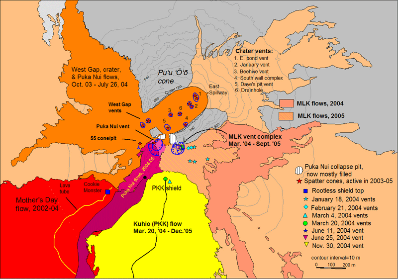
Map shows vents, lava flows, and other features near Pu`u `O`o frequently referred to in updates. These features can change quickly, but this map should help those viewers lost in the terminology. The vents, lava tubes, and flows active in 2005 include the numbered vents in the crater, the MLK vent complex and associated flows, the Puka Nui vent, and the upper Kuhio (PKK) tube, which feeds the lava flows eventually reaching the ocean.
Get Our News
These items are in the RSS feed format (Really Simple Syndication) based on categories such as topics, locations, and more. You can install and RSS reader browser extension, software, or use a third-party service to receive immediate news updates depending on the feed that you have added. If you click the feed links below, they may look strange because they are simply XML code. An RSS reader can easily read this code and push out a notification to you when something new is posted to our site.