An official website of the United States government
Here's how you know
Official websites use .gov
A .gov website belongs to an official government organization in the United States.
Secure .gov websites use HTTPS
A lock () or https:// means you’ve safely connected to the .gov website. Share sensitive information only on official, secure websites.
Scientists on the early morning overflight of Kīlauea Volcano's lower East Rift Zone documented a very weak ocean entry. For the easternmost lobe, only a few small finger channels of lava were entering the ocean.
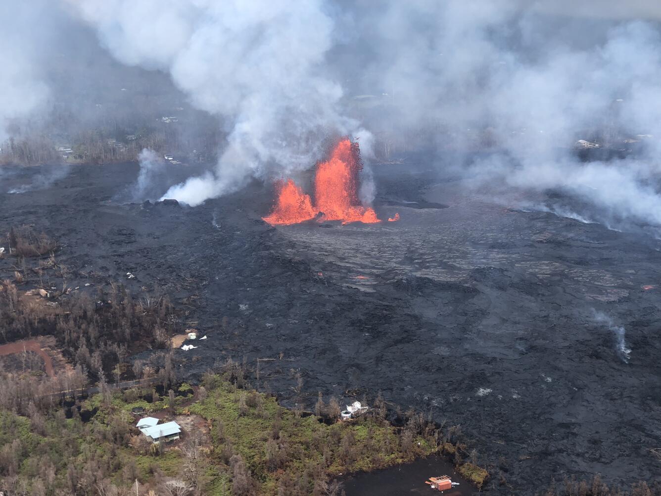
Fissure 8 reactivated
Fissure 8 reactivated on the afternoon of May 28, when, at times, lava fountains were reaching heights of 200 feet and feeding a lava flow that advanced to the northeast.
Video of fissure 8, as observed during a helicopter overflight on May 29, 2018, and as viewed from ground level. Fissure 8 was fountaining to heights of 200 feet at times, and feeding a lava flow that was traveling to the northeast.
Tephra (airborne lava fragments) erupted by the high lava fountains of fissure 8 was carried downwind, where the frothy rock fragments fell on Leilani Street, just past Kupono Street, in the Leilani Estates subdivision.
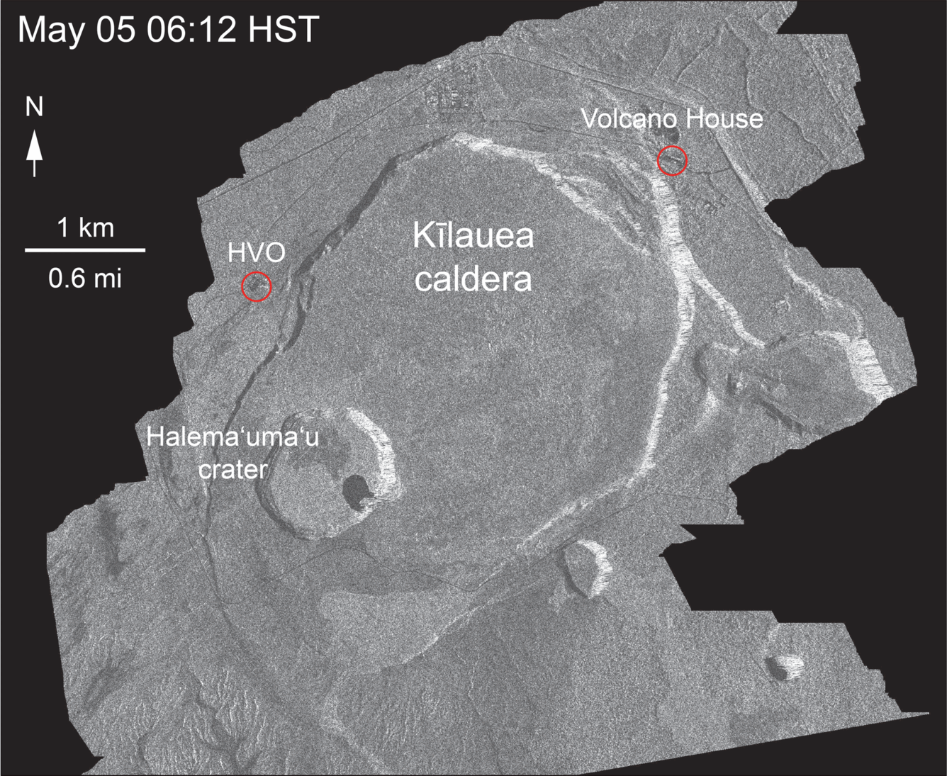
Radar image from May 29 at 6:12 AM shows enlargement of summit eruptive vent
This animated GIF shows a sequence of radar amplitude images that were acquired by the Italian Space Agency's Cosmo-SkyMed satellite system. The series shows changes to the caldera area of Kīlauea Volcano that occurred over May 5 at 6:12 a.m. HST, May 17 at 6:12 a.m. HST, May 21 at 6:12 a.m. HST, and May 29 at 6:12 a.m. HST. The satellite transmits a radar signal at the surface and measures the strength of the return, with bright areas indicating a strong return and dark areas a weak return. Strong returns indicate rough surfaces or slopes that point back at the radar, while weak returns come from smooth surfaces or slopes angled away from the radar.The May 5 image was acquired before any small explosions occurred from the summit. The May 17, 21, and 29 images show changes to the summit area after the onset of small explosions and ash emissions. Major changes over time include: (1) a darkening of the terrain south of Halema‘uma‘u, which reflects accumulation of ash; (2) enlargement of the summit eruptive vent on the floor of Halema‘uma‘u. The apparent slumping of the east rim of Halema‘uma‘u is not actual motion of the ground, but is an effect of the radar viewing angle, which is from the side instead of being straight down.
Get Our News
These items are in the RSS feed format (Really Simple Syndication) based on categories such as topics, locations, and more. You can install and RSS reader browser extension, software, or use a third-party service to receive immediate news updates depending on the feed that you have added. If you click the feed links below, they may look strange because they are simply XML code. An RSS reader can easily read this code and push out a notification to you when something new is posted to our site.