An official website of the United States government
Here's how you know
Official websites use .gov
A .gov website belongs to an official government organization in the United States.
Secure .gov websites use HTTPS
A lock () or https:// means you’ve safely connected to the .gov website. Share sensitive information only on official, secure websites.
A new eruption at Kīlauea's summit began at approximately 3:20 p.m. HST on September 29, 2021. Lava activity is currently confined within Halema'uma'u crater. Gas emissions and seismic activity at the summit remain elevated. HVO field crews—equipped with specialized safety gear—monitor the eruption from within the closed area of Hawai‘i V
HVO scientists collect detailed data to assess hazards and understand how the eruption is evolving at Kīlauea's summit, all of which are shared with the National Park Service and emergency managers. Access to this hazardous area is by permission from, and in coordination with, Hawai‘i Volcanoes National Park.
On the evening of September 30, 2021, the new eruption in Halema'uma'u at Kīlauea summit continued with several active vents in the middle of the lake and on the west side. USGS image by K. Lynn.
Lava fountains through the lava lake in Halema‘uma‘u, at Kīlauea's summit, create waves or ripples in the lake surface. The ripples are visible on the surface as thin crustal plates move apart and back together again as the wave motion passes by (like inner tubes in a crowded wave pool), creating a moving arc of increased glow. Video taken early Thursday morning, September 30, 2021. (Preview image is just the main fountaining source from September 30). USGS video by B. Carr.
This overview photo of the lava lake within Halema‘uma‘u was captured from the west rim of the crater shortly after noon on September 30, 2021. Several fissures, erupting through the lava lake, stretch from the lake's center to its southern (right) margin. Another fissure erupts in the western wall of Halema‘uma‘u (near side) just several meters (yards) above the lake surface. Three features from the December 2020–May 2021 eruption remain visible: the western fissure (darker spot on near side), the main island (center), and another smaller island in the eastern part of the lake (upper left). USGS photo by M. Zoeller.
Morning light and shifts in the volcanic gas plume allowed field crews on September 30 to glimpse the surface of the main island that remains from the 12/2020–5/2021 lava lake. The island appears to be blanketed with a new coating of spatter and tephra from nearby fissures within the lava lake, with minor overflows at the edges. Measurements by field crews indicated that the highest point on the island is 8 m (26 ft) higher than it was earlier this month; since it is unlikely that the deposit of new spatter and tephra is actually this thick, the measurements seem to indicate the island has lifted up and is floating within the lava lake once again. This zoomed-in view shows the northeast part of the island. USGS photo taken by M. Zoeller.
USGS Hawaiian Volcano Observatory scientists continue to monitor the new eruption at in Kīlauea's Halema‘uma‘u crater on the evening of September 30, 2021. Field crews made measurements of the active fountains and the lava lake level to track how quickly it is rising. This photo was taken from a closed area of Hawai‘i Volcanoes National Park. USGS Photo by K. Lynn.
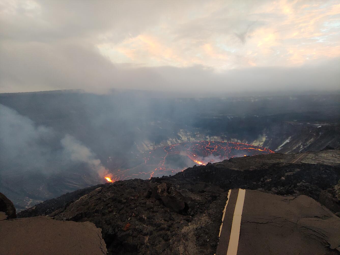
On the evening of September 30, 2021, linear fissures remained active in the middle of the Halema‘uma‘u lava lake at Kīlauea. This photo was taken from the south, looking north, in a closed area of Hawai‘i Volcanoes National Park, where USGS Hawaiian Volcano Observatory monitor the eruption with National Park Service permission. USGS Photo by K. Lynn.
Around 6 p.m. HST on September 30, 2021, Kīlauea's new eruption in Halema‘uma‘u continued with vigorous fountain activity at the new vent on the western crater wall. This view is from the south caldera rim looking to the west at the approximately 15 m (50-ft) high fountain measured over a five minute interval. This photo was taken from a closed area of Hawai‘i Volcanoes National Park. USGS Photo by K. Lynn.
This zoomed-in photo of the western fissure within Halema‘uma‘u was captured at 9:00 a.m. on September 30, 2021. Eruptive activity at this location is very similar to that of the northern fissure from the December 2020 eruption, with lava fountains feeding a short cascade down to the rising lava lake. Using a laser rangefinder, field crews estimated that these fountains were reaching heights of 10–12 m (33–39 ft) above their base. USGS photo by M. Zoeller.
A view of the new eruption within Halema'uma'u at Kīlauea summit at approximately 9 a.m. HST on the morning of October 1, 2021. This view, from the south rim of Halema'uma'u, shows that lava continues to erupt from multiple vents along the floor and western wall of Halemaʻumaʻu crater. Over the past 24 hours, the lava lake surface has risen approximately 4 meters (4.4 yds). Sulfur dioxide (SO2) emission rates remain high and were estimated at around 20,000 tonnes per day the morning of September 30, 2021. This is significantly lower than the initial emission rates of 85,000 tonnes per day that were measured just after the eruption started on the afternoon of September 29, 2021. USGS photo by F. Trusdell.
Two vents on the western wall of Halema‘uma‘u crater, at Kīlauea summit, remain active. The western fissure opened about an hour and a half (around 4:40 p.m.) after the eruption began on Sept. 29, 2021. The pinkish and black area within the lava lake (near the center of the photo) is the partially submerged west vent that formed during the Dec. 2020–May 2021 eruption. This photo was taken from the southern rim of Halema‘uma‘u crater at 9:05 a.m. HST on Oct. 1, 2021. USGS photo by J.M. Chang.
This telephoto image shows two vents that formed on the western wall of Halema‘uma‘u crater during the current eruption of Kīlauea, which began on September 29, 2021. The photo was taken from the southern rim of Halema‘uma‘u crater at 9:02 a.m. HST on Oct. 1, 2021, in an area of Hawai‘i Volcanoes National Park that remains closed to the public due to safety reasons. USGS photo by J.M. Chang.
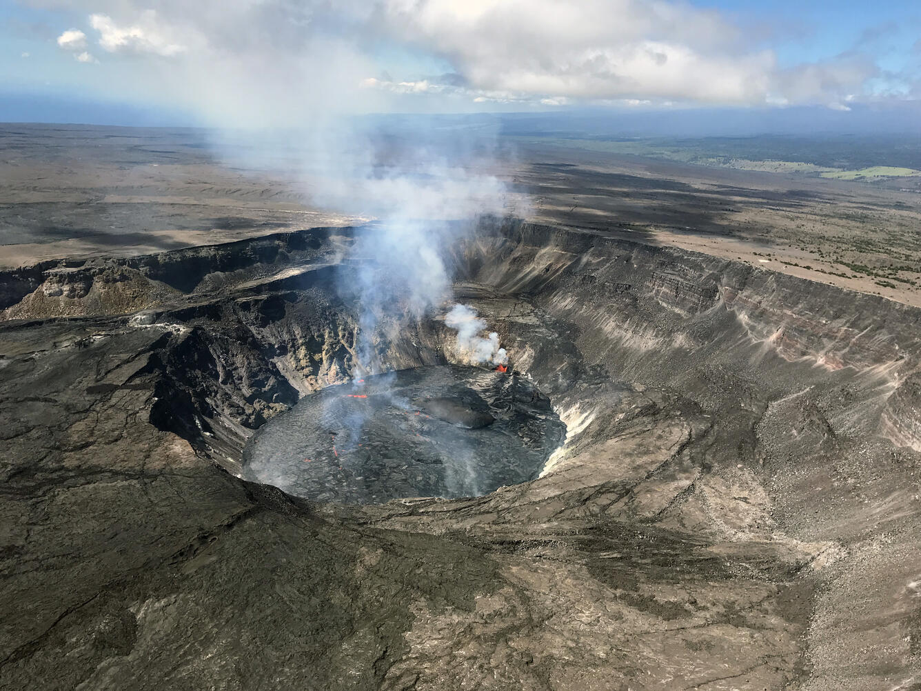
The Kīlauea summit eruption continues within Halemaʻumaʻu crater, in Hawai‘i Volcanoes National Park. This wide view of the new lava lake was taken this morning, October 1, 2021, during a Hawaiian Volcano Observatory eruption overflight. Volcanic gas emissions remain elevated with lava fountains from the vent on the western crater wall, and from within the lava lake, producing the largest gas plumes. USGS photo taken by L. DeSmither.
The growing lava lake within Halemaʻumaʻu, at the summit of Kīlauea, has risen roughly 27 m (89 ft) since the eruption started on September 29, 2021 at 3:21 p.m. HST. The eruption began with a fissure opening along the floor of Halemaʻumaʻu, through the surface of the solidified 2020–21 lava lake. This fissure produced a line of lava fountains—many of which have been drowned by the deepening lava lake—with only a few low fountains still visible on the central and south-central lake surface (center and center-left of image). The fissure that opened in the western crater wall—around 4:40 p.m. on September 29—is visible on the far side of the lava lake. USGS photo taken by L. DeSmither at approximately 10:00 a.m. on October 1, 2021.
A telephoto view of the south-central and western fissure fountains that continue to erupt lava into the growing lava lake at Kīlauea summit. The lava lake and eruptive activity are confined within Halemaʻumaʻu crater, in Hawai‘i Volcanoes National Park. The “lava island” that formed during the opening hours of the 2020–21 eruption is visible on the lava lake surface in the center of this image. USGS photo taken by L. DeSmither on October 1, 2021.
A helicopter overflight the morning of October 1, 2021, provided aerial views of the eruption within Halema‘uma‘u, at Kīlauea's summit. This view, looking to the west, shows an active lava fountain located within the south-central part of the lava lake. This fountain is only a few meters (yards) high. USGS photo by D. Downs.
Aerial image looking to the west of the large island that is floating within the middle of the lava lake in Halema‘uma‘u, at Kīlauea's summit. There are several vents with fountains reaching to just a few meters (yards) high. One of the vents along the eastern margin of the island has started to form spatter ramparts to enclose it. USGS photo by D. Downs.
Aerial view of the active lava lake and vents within Halema‘uma‘u crater, at the summit of Kīlauea. This view is looking to the northwest. Since the start of the eruption on September 29, 2021, much of the topography of the previous lava lake (active between December 2020 and May 2021) has been covered with newer lava; however, features of the previous lava lake remain, such as the light-brown-colored island located within the middle of the lava lake. USGS photo by D. Downs.
Aerial image looking to the southwest and showing fissures within Halema‘uma‘u, at Kīlauea's summit, producing lava fountains within the southern and south-central part of the lava lake. These lava fountains are less energetic than when the eruption started on September 29, 2021, but are still spattering to heights of about 5 meters (16 ft) or less. USGS photo by D. Downs.
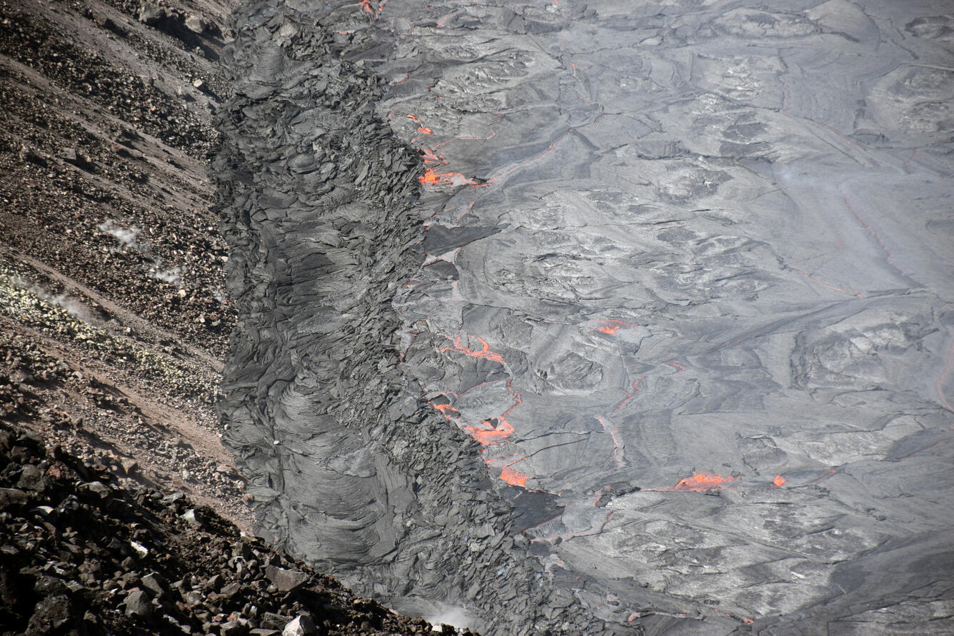
This telephoto image of the lava lake margin was taken during a Hawaiian Volcano Observatory Kīlauea summit eruption overflight this morning. The lava lake within Halemaʻumaʻu crater is forming a “perched” levee around parts of the lake perimeter. The levee is formed, in part, by pieces of the lava lake surface crust being pushed on the levee by the lake circulation. The crust slabs become stacked on top of one another in a chaotic manner, which is visible here. USGS photo taken by L. DeSmither on October 1, 2021.
Aerial photo taken during a morning overflight on October 1, 2021, and looking at the west end of the lava lake within Halema‘uma‘u crater, at the summit of Kīlauea. The west vent that is feeding this part of the lava lake is visible; the base of this vent was well above the lava lake when it opened on the afternoon of September 29, 2021. Since then, the lava lake has risen to the base of this vent. USGS photo by D. Downs.
A telephoto view of the western fissure that opened in the wall of Halemaʻumaʻu crater, during the new Kīlauea summit eruption. Spatter from the lava fountains have built a horseshoe-shaped cone (black lava) surrounding the upper part of the fountain, while lava flows into the lava lake at the base of the vent. A weak lava flow can be seen exiting a smaller vent to the north (right) of the main fountain. Dark solidified lava spatter is also visible to the south (left) of the main fountain, where lava was erupted briefly during the early stages of this fissure. The top of the old west vent from the 2020–21 eruption is visible in the lower right of the image. USGS photo by L. DeSmither taken on October 1, 2021.
A Hawaiian Volcano Observatory (HVO) scientist takes photos of the Kīlauea summit eruption, within Halema‘uma‘u crater, during today’s helicopter overflight. In addition to making eruption observations and taking photos and videos to share with the public, scientists also collect consecutive and overlapping visual and thermal images to make eruption models and thermal maps. USGS photo taken by L. DeSmither on October 1, 2021.
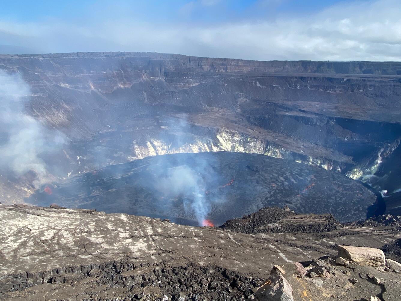
In the afternoon of October 1, 2021, Hawaiian Volcano Observatory scientists observed the ongoing eruption within Halemaʻumaʻu from the northwest rim of the crater at Kīlauea's summit. The two dominant eruptive vents at this time are the western fissure (lower-right) and a fountaining area in the central-southern part of the lava lake (center), though minor spattering continues at other scattered vents. USGS photo by M. Zoeller.
On September 30, 2021, a Hawaiian Volcano Observatory gas scientist takes notes based on the spectra being displayed by the field laptop, which is connected to a FTIR spectrometer on the rim of Halema‘uma‘u crater. The FTIR is measuring the composition of volcanic gases being emitted during an eruption within Halema‘uma‘u, at Kīlauea summit, by measuring how the plume absorbs infrared energy. USGS photo by P. Nadeau.
On September 30, 2021, Hawaiian Volcano Observatory gas scientists used a FTIR spectrometer on the rim of Halema‘uma‘u crater to measure the composition of gases being emitted during Kīlauea's summit eruption, which began the afternoon of Septembe 29, 2021. The eruption is generating a plume consisting primarily of sulfur-dioxide (SO2), but also containing water vapor (H2O), carbon dioxide (CO2), and halogen gases such as HCl and HF. Sulfur dioxide (SO2) emission rates were estimated at around 20,000 tonnes per day the morning of September 30, 2021. This is significantly lower than the initial emission rates of 85,000 tonnes per day that were measured just after the eruption started on the afternoon of September 29, 2021. USGS photo by T. Elias.