
Volcano Watch — Water, ash, and the great unknown of explosive volcanic eruptions
The presence of water in Halema‘uma‘u has sparked an important discussion about what the pond means for future eruptions at Kīlauea Volcano. There are no written records of water at the summit, so to guide the discussion we need information about magma-water interaction from deposits of the past.

But how can we get that information? I set out to answer this very question some years ago, and like many scientific quests, it started with a frustrating discovery.
Sitting in my lab one defining afternoon, I was studying the explosive nature of Icelandic volcanoes at the University of Iceland. Our grain shape analyzer sat in its lavender box on the lab bench, humming loudly, as a pump ran my sample of volcanic ash through a water-filled tubing system.
The grains went through an inch-long lens in front of a camera with a high-pitched shutter clicking manically at 30 frames per second. The screen next to the instrument showed a live stream of images with black particles on a light grey backdrop. In the sample bag, these same grains looked like tiny dust specks, but magnified on the screen, they came to life as abrasive, glassy shards of volcanic ash.
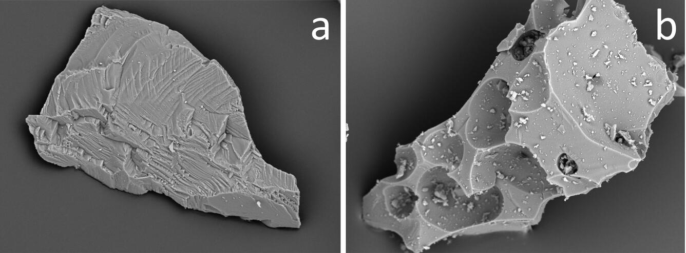
I had been in the lab for several hours that day and for weeks before that. My experiment built on the observation that ash generated by different types of volcanic explosions had different shapes. Ash from explosions caused by the expansion of magmatic gases looked like tiny pieces of frozen foam with broken bubble walls. Ash from explosions in which hot magma interacted with liquid water looked like broken glass shards—dense and blocky.
This distinction was first observed in the 1970s using big, expensive electron microscopes to view a small selection of grains. During my study with the new shape analyzer, however, we had the opportunity to get information on many thousand grains all at once, and I intended to use that to characterize some puzzling big ash deposits in Iceland, and to look for a link with magma-water interaction.
When the aggravating shutter clicking finally stopped, I pressed "export data" on the screen and ran to my desk to get the first peek at my achievement. I held my breath as the computer worked to plot results from all 20,000 grains, and then gasped in disbelief. My plot came out with grain shapes all over the place with no systematic groupings at all. I tried another sample, then one more and yet another, and I felt crushed! Many months of hard work seemed useless.
After days of checking my instrument setup, the quality of my data, and digging through a lot of scientific papers, I finally had an idea. The old experiments had characterized only a few grains, so perhaps something was missing in the classification scheme. So, I went back to my photos of individual ash grains and started to classify their shapes according to how much they were influenced by broken bubbles and consequently by magmatic gas expansion.
The grains weren't just foamy or dense. Instead, I saw a spectrum of shapes, from blocky shards with dense glass and no bubbles, then blocky shards with a few isolated bubbles, to progressively more foamy grains. This was exciting!
Over the following weeks I worked to put this new information into a classification diagram. I collected new samples from different types of explosive eruptions for which I already knew if water was involved or not.
Some lab sessions later, I once again held my breath in front of my computer, but this time it worked! There was a predictable and systematic difference to the test samples. The Icelandic ash turned out to be the result of both magmatic gas expansion and magma-water interaction. We now have a more flexible way to characterize how water influences volcanic eruptions just from looking at the shapes of tiny ash grains.
I am now in Hawai‘i, collecting samples of ash from Kīlauea to figure out what role water has played in past summit eruptions. Results will be discussed in a future Volcano Watch, so stay tuned!
Todays article is by Johanne Schmith, an Associate Postdoc funded by the Carlsberg Foundation Internationalisation Fellowship, whose work on Kīlauea was the subject a recent Volcano Watch.
Volcano Activity Update
Kīlauea Volcano is not erupting. Its USGS Volcano Alert level remains at NORMAL (https://volcanoes.usgs.gov/vhp/about_alerts.html). Kīlauea updates are issued monthly.
Kīlauea monitoring data over the past month showed no significant changes in seismicity, sulfur dioxide emission rates, or deformation. The water lake at the bottom of Halema‘uma‘u continued to slowly expand and deepen.
Mauna Loa is not erupting. Its USGS Volcano Alert level remains at ADVISORY. This alert level does not mean that an eruption is imminent or that progression to an eruption is certain. Mauna Loa updates are issued weekly.
This past week, HVO recorded about 42 small-magnitude earthquakes, all less than M2.0, beneath the upper elevations of Mauna Loa. Monitoring data showed that slow summit inflation continued and fumarole temperature and gas concentrations on the Southwest Rift Zone remain stable.
Seven earthquakes with three or more felt reports occurred in Hawai‘i this past week: a magnitude-3.0 quake 16 km (10 mi) south of Fern Acres at 5 km (3 mi) depth on March 25 at 4:54 p.m. HST; a magnitude-3.2 quake 8 km (5 mi) northeast of Pāhala at 31 km (19 mi) depth on March 24 at 7:45 a.m.; a magnitude-3.3 quake 14 km (9 mi) southeast of Volcano at 1 km (1 mi) depth on March 21 at 6:55 a.m.; a magnitude-3.8 quake 16 km (10 mi) southeast of Volcano at 1 km (1 mi) depth on March 21 at 5:07 a.m.; a magnitude-3.9 quake 7 km (4 mi) northwest of Pāhala at 0 km (0 mi) depth on March 19 at 6:54 a.m.; a magnitude-2.6 quake 12 km (7 mi) southeast of Volcano at 6 km (4 mi) depth on March 19 at 6:48 a.m.; and a magnitude-2.3 quake 22 km (14 mi) northeast of Hōnaunau-Nāpō‘opo‘o at 3 km (2 mi) depth on March 19 at 6:32 a.m.
HVO continues to closely monitor both Kīlauea and Mauna Loa.
Get Our News
These items are in the RSS feed format (Really Simple Syndication) based on categories such as topics, locations, and more. You can install and RSS reader browser extension, software, or use a third-party service to receive immediate news updates depending on the feed that you have added. If you click the feed links below, they may look strange because they are simply XML code. An RSS reader can easily read this code and push out a notification to you when something new is posted to our site.