
500 Years of Extreme Potomac Floods at Washington D.C.
Large floods on the Potomac River in Washington D.C. can be documented as early as 1784, and based on historical data and recent measurements, have occurred with increasing frequency since the mid-19th century. Human modifications to the Potomac estuary since Washington D.C. was established as the Federal capital, as well as increasingly heavy rainfall and land clearance in the watershed, likely contributed to more frequent large floods.
Issue
Washington D.C. faces one of the highest 100‐year flood risks of any major city along the U.S. East Coast. In addition to sea-level rise and storm‐surge inundation during hurricanes and nor'easters, extreme water‐levels at Washington are strongly skewed by major floods on the Potomac River. Understanding the magnitude and drivers of past flooding events can help managers prepare for future events in the region.
USGS Study
Historic Potomac flood observations and flood data obtained from sediment cores were combined with more recent water-level measurements to determine if the magnitude of flooding has increased in Washington D.C. during past centuries. How sea‐level rise has contributed to flood risk in the area was also examined, along with indications of how changes in land-use practices and increasing precipitation have contributed to flooding.
Major Findings
The composite record of contemporary, historic, and geologic proxy water‐level data demonstrates:
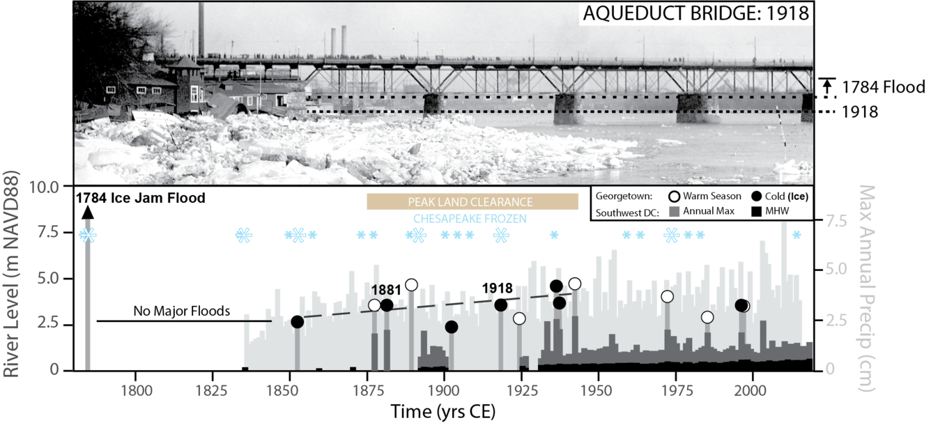
- Washington D.C. is susceptible to ice‐jam floods that are significantly larger than those observed during the recent past (Figure 1).
- The frequency of large Potomac floods increased following the mid-19th century with most occurring between 1870 and 1945, coinciding with changes to forest cover in the watershed, human modifications to the river and heavier rainfall events.
- Mean river level has also increased ∼0.7 m on the Potomac estuary since Washington was established as the U.S. Federal capital.
- Structures built along the city’s waterfront, designed relative to 19th century low water, may be impacted by future events as floods are increasingly compounded by 21st century sea‐level rise.
Management Implications
Past infilling in the Potomac estuary, as well as land clearance and heavier rainfall across the watershed may have decreased the capacity of the estuary to transport flow under fair weather and possibly flood conditions. Changing land use practices have also likely driven extensive soil erosion and increased runoff yields, while infrequent deep ice cover on the Chesapeake Bay can increase the risk of ice jam flooding. Ice-jam flooding occurs when chunks of ice block river flows, causing water to rise behind the jam and once released, deliver a surge of water that can cause downstream flooding.
Low-lying parts of Washington D.C. are thus susceptible to several types of floods, including direct hurricane storm surge, weakening tropical systems that deliver large amounts of rainfall, and infrequent large snowfalls followed by rapid thawing. Knowledge of past flood events, combined with more recent water-level measurements can help guide management decisions regarding land- use practices to limit runoff and the potential need to bolster waterfront structures against future flooding.
For More Information
The full study is published online with open access: https://doi.org/10.1029/2025GL118329.
Large floods on the Potomac River in Washington D.C. can be documented as early as 1784, and based on historical data and recent measurements, have occurred with increasing frequency since the mid-19th century. Human modifications to the Potomac estuary since Washington D.C. was established as the Federal capital, as well as increasingly heavy rainfall and land clearance in the watershed, likely contributed to more frequent large floods.
Issue
Washington D.C. faces one of the highest 100‐year flood risks of any major city along the U.S. East Coast. In addition to sea-level rise and storm‐surge inundation during hurricanes and nor'easters, extreme water‐levels at Washington are strongly skewed by major floods on the Potomac River. Understanding the magnitude and drivers of past flooding events can help managers prepare for future events in the region.
USGS Study
Historic Potomac flood observations and flood data obtained from sediment cores were combined with more recent water-level measurements to determine if the magnitude of flooding has increased in Washington D.C. during past centuries. How sea‐level rise has contributed to flood risk in the area was also examined, along with indications of how changes in land-use practices and increasing precipitation have contributed to flooding.
Major Findings
The composite record of contemporary, historic, and geologic proxy water‐level data demonstrates:
- Washington D.C. is susceptible to ice‐jam floods that are significantly larger than those observed during the recent past (Figure 1).
- The frequency of large Potomac floods increased following the mid-19th century with most occurring between 1870 and 1945, coinciding with changes to forest cover in the watershed, human modifications to the river and heavier rainfall events.
- Mean river level has also increased ∼0.7 m on the Potomac estuary since Washington was established as the U.S. Federal capital.
- Structures built along the city’s waterfront, designed relative to 19th century low water, may be impacted by future events as floods are increasingly compounded by 21st century sea‐level rise.
Management Implications
Past infilling in the Potomac estuary, as well as land clearance and heavier rainfall across the watershed may have decreased the capacity of the estuary to transport flow under fair weather and possibly flood conditions. Changing land use practices have also likely driven extensive soil erosion and increased runoff yields, while infrequent deep ice cover on the Chesapeake Bay can increase the risk of ice jam flooding. Ice-jam flooding occurs when chunks of ice block river flows, causing water to rise behind the jam and once released, deliver a surge of water that can cause downstream flooding.
Low-lying parts of Washington D.C. are thus susceptible to several types of floods, including direct hurricane storm surge, weakening tropical systems that deliver large amounts of rainfall, and infrequent large snowfalls followed by rapid thawing. Knowledge of past flood events, combined with more recent water-level measurements can help guide management decisions regarding land- use practices to limit runoff and the potential need to bolster waterfront structures against future flooding.
For More Information
The full study is published online with open access: https://doi.org/10.1029/2025GL118329.