
Florence Bascom Geoscience Center
The primary mission of the Florence Bascom Geoscience Center (FBGC) is to provide detailed scientific data and assessments to support natural resource management, public safety, and national security. The FBGC specializes in:
Geologic mapping and hazards
Paleontology, stratigraphy, and environmental geology
Special geologic studies at the intersection of national security and mineral resources
USGS Scientists Help Address Conflict Mining

The USGS has collaborated with several international organizations working to track and monitor illegal mining and armed groups funded by natural resources around the world.
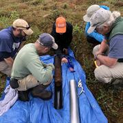
Mid-Atlantic Stream & Sediment Science

FBGC's ecologist Greg Noe's work is highlighted in this great article discussing legacy erosion and sedimentation in Mid-Atlantic watersheds.
Climate Change Impacts on Mangrove Forests

FBGC scientists Miriam Jones and Lynn Wingard were recently interviewed by NPR regarding climate change and mangrove forests.
Publications
Evidence for a biological origin of uranium-rich carbon masses within the Ediacaran Salt Range Formation of Pakistan Evidence for a biological origin of uranium-rich carbon masses within the Ediacaran Salt Range Formation of Pakistan
Petrography and mineralogy of selected pre-Middle Jurassic basement rocks beneath the Atlantic and Gulf Coastal Plains in Florida Petrography and mineralogy of selected pre-Middle Jurassic basement rocks beneath the Atlantic and Gulf Coastal Plains in Florida
Monazite and xenotime U-Pb geochronology and thermometry of the Blue Ridge and Inner Piedmont of North Carolina: Implications for the thermal-metamorphic evolution of the southern Appalachian metamorphic “core” Monazite and xenotime U-Pb geochronology and thermometry of the Blue Ridge and Inner Piedmont of North Carolina: Implications for the thermal-metamorphic evolution of the southern Appalachian metamorphic “core”
Science

500 Years of Extreme Potomac Floods at Washington D.C.
Paleoscience for Partners: Reconstructing the Past to Prepare for the Future
