
From Analog to Digital: Eight Decades of Tracking Box Turtles on Patuxent Research Refuge
Researchers from U.S Geological Survey and U.S. Fish and Wildlife Service have been monitoring eastern box turtles (Terrapene carolina Carolina) on the Patuxent Research Refuge in Laurel, MD since the 1940s.
The creation of the Department of Interior’s Patuxent Wildlife Research Center in 1939 inspired federal biologists to begin wide-ranging studies of many of the species on the Patuxent Research Refuge, which had been established as the nation’s first and only national wildlife refuge devoted to wildlife research three years earlier. Some of these investigations continue today as part of the research conducted by the U.S. Fish and Wildlife Service (USFWS) and U.S. Geological Survey’s Eastern Ecological Science Center (USGS EESC), which has one of its primary campuses on the central tract of the refuge in Laurel, MD.
Early surveys of box turtles on the refuge
Lucille Stickel, the director of the Patuxent Wildlife Research Center from 1972 to 1982, initiated a field study of eastern box turtles (Terrapene carolina Carolina) during 1944-1947 as part of her doctoral research (Stickel 1950). The primary goals of this early research were to determine population size and home range relationships, including whether turtles defended their home range as territories, size of home ranges, and movement patterns of turtles within and outside of their home ranges. Box turtles are ideal for studying population ecology because they are relatively slow and easy to capture, can be individually marked for identification, are active primarily during the day (and thus can be observed during most of their activity period) and are long lived so can be monitored and studied across many years.
When first captured on the center, turtles were uniquely and permanently identified by filing notches along the margins or scutes of their top shells (carapace) according to a code system established in the 1930s. Within the first 18-20 years of life, turtle ages can be estimated by counting the number of growth rings on their carapace. To track turtle movements, Dr. Stickel improved on an earlier trailer design described in 1927 (see Image 1 in slideshow below) and noted, “Details of travels can be followed for weeks or months by attaching thread- laying devices to their carapaces. Their normal activities are not detectably altered by the attachment of these trailers, or by handling and marking.” This method allowed her to follow and map the travels of eleven of turtles for 456 turtle days, including following one individual turtle for 161 days! In addition to their daily movements, she was able to observe and describe their seasonal use of landscape and habitats, their foraging, mating and nesting behaviors and was the first to locate and define the “form,” a structure turtles construct as a hide or retreat.
In the 1940’s, Dr. Stickel initiated annual box turtle surveys within a 11.8-ha site on the Patuxent Research Refuge. Data were analyzed once each decade during 1945-1975 to study the population dynamics of this long-lived species. Turtles that had been captured during previous years could be identified by their scute notches allowing her to investigate seasonal and annual growth patterns and development. Over time, turtle ages could be estimated based on the number and size of carapacial growth rings at first capture and time between captures. This “mark-capture-recapture” approach allows for individuals to be tracked throughout their lives. By the 1975 survey, some turtles were estimated to be over 50 years old. Dr. Stickel documented a pronounced decline in the estimated population of box turtles, including a reduction by half between 1965 and 1975 (Stickel 1978). She proposed that declines may have been related to changes in forest habitat, including increased intensity of flood events, expansion of highways, new housing development and heightened traffic around the refuge study site.
Expansion of monitoring methods
Concerned about the apparent declines in the local box turtle population and to maintain records of persistence of individual turtles, the decadal surveys continued in 1985 and 1995. By continuing the decadal surveys using the same methods from 1945, researchers could better track changes in the apparent population over time. Unfortunately, the 1995 population appeared to be no more than 23% of the peak population of 1945 (Hall, Henry and Bunck 1999). In 1995 researchers added radiotelemetry to track seasonal movement of nine turtles and evaluate search efficiency. Researchers including Dr. Paula F. Henry, a research physiologist at USGS EESC, noted, “turtles are far less visible than formerly assumed; even when the location of an individual could be narrowed to a few square meters, it often took observers great effort to sight a turtle that was only thinly concealed by vegetation or debris… a single searcher had on the average only slightly more than a 10% chance of finding them in a normal search session without the aid of radio signals.” Radio tracking also revealed turtle movements to be more extensive and complex than previous studies had suggested.
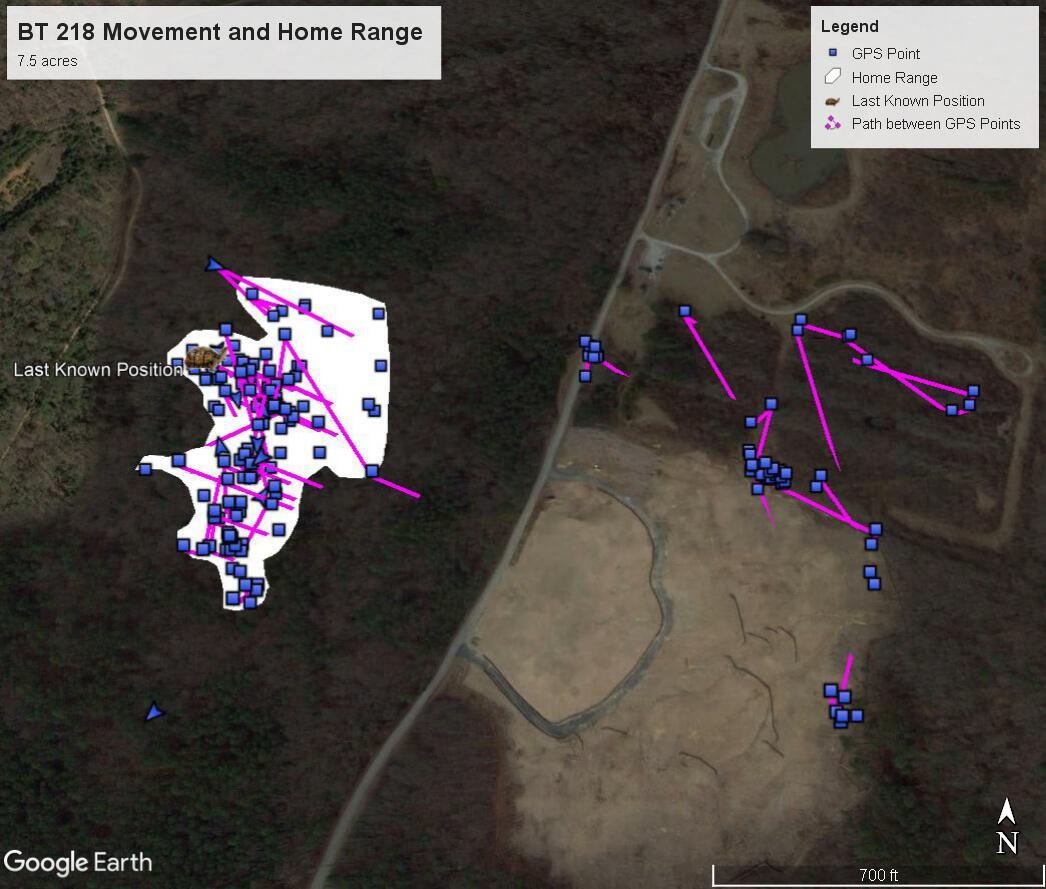
Advances in technology support monitoring today
Mark-capture-recapture methods like those used throughout the 1900s can be effective when done correctly but involve significant time and physically-invasive procedures, making them inappropriate for species at risk like box turtles. In 2017, Sandy Spencer, USFWS wildlife biologist, began tracking five female box turtles throughout the refuge using solar-powered cellular transmitters (see Image 2). X-rays were used to determine that each of these females was gravid (preparing to lay eggs) which would offer new information to the monitoring efforts about nesting behaviors. Cellular transmitters provide an advantage over radio transmitters because information about turtle locations can be automatically uploaded to cellular towers based on a pre-programmed schedule instead of relying on field personnel to manually relocate the turtle from its transmitter signals using a hand-held receiver.
The cellular transmitters record GPS coordinates, speed and direction of travel and allow for detailed records of movement patterns without the need for tracking (or disturbing) the turtles in the field. These transmitters are solar powered and only function when turtle is above ground, approximately mid-April to late October. To date, transmitter data have shown home ranges of gravid females ranging from 5.4-7.8 acres. As of October 2022, four of the cellular transmitters are still sending data three times weekly. In addition, the data can be viewed through a GoogleEarth interface that displays GPS locations and lines of travel between these locations and allows researchers to create maps of varying spatial and temporal scales (see Image 3). Also from 2016-2018, Spencer employed an incidental sightings technique taking advantage of the many personnel and road systems on the refuge. This method resulted in 379 individual turtles captured and marked and 29 recaptures throughout most of the refuge’s nearly 13,000 acres.
In 2019, USGS EESC research statistician Dr. Andy Royle launched the Quantitative Turtle Analysis Project to overcome some of the challenges related to mark-recapture-capture methods by developing new approaches that are also applicable to other species and geographic areas. Specifically, the project investigates how digital images can be used by automated programs to recognize unique individual turtles in place of marking systems like scute notching, and how uncertain individual identifications can be used in capture-recapture methods. Machine learning programs can differentiate between individual turtles using pictures of their shells instead of permanent notches (computer-assisted photo-ID capture-recapture). New “spatial-capture-recapture” models also account for the unbalanced search effort of observers by using GPS tracks to record what areas were surveyed (see Image 4).
Modern efforts to monitor box turtles on the refuge also involve a community approach, including training the next generation of scientists and leveraging the interest of those who spot box turtles on their visits to the refuge. Between 2000-2015, the historic records of the marked and recaptured turtles found between 1942-2015 and the 11.8 ha site were the bases for projects conducted by multiple community volunteers; research by students at River Hill High School, Howard County Community College, Hood College, Towson University, and University of MD-College Park; and an intern working with the U.S. Humane Society.
For the last four years, USGS EESC has hired a summer intern to track the refuge’s box turtles through the USGS Cooperative Summer Fellowship Program. This is a partnership with the Ecological Society of America’s Strategies for Ecology Education, Diversity and Sustainability program, which aims to support and retain diverse talent in the ecological sciences. Youth Conservation Corps students stationed at the refuge often assist with fieldwork as part of their summer program. USGS EESC has also worked with students in Eleanor Roosevelt High School’s Science and Technology Program to develop computer algorithms to identify individual box turtles from measurements of their shells using photos taken by both trained biologists who work at Patuxent Research Refuge and community scientists. USFWS issues a special use permit to allow this work to continue in non-public areas of the refuge and collaborates with USGS on the turtle numbering system to build the count of unique individuals. To date, field technicians and community scientists have collectively provided over 500 photographs of turtles, contributing meaningful data for tracking the population of turtles on the refuge.


Follow USGS EESC on Facebook at facebook.com/USGSEESC for the latest updates on our research on fish and wildlife from headwaters to oceans and ways you can get involved, including events at Patuxent Research Refuge.
Related

Quantitative Turtle Analysis Project: Machine learning with turtles

The Eastern Box Turtle at USGS Patuxent Research Refuge, MD
Related
Quantitative Turtle Analysis Project: Machine learning with turtles