



Redesigning the Eastern Breeding Waterfowl Population and Habitat Survey
USGS and partners are revising the design of a key waterfowl survey to increase management efficiency and cost-effectiveness, and inform annual harvest regulations in the U.S. and Canada.
What is the issue?
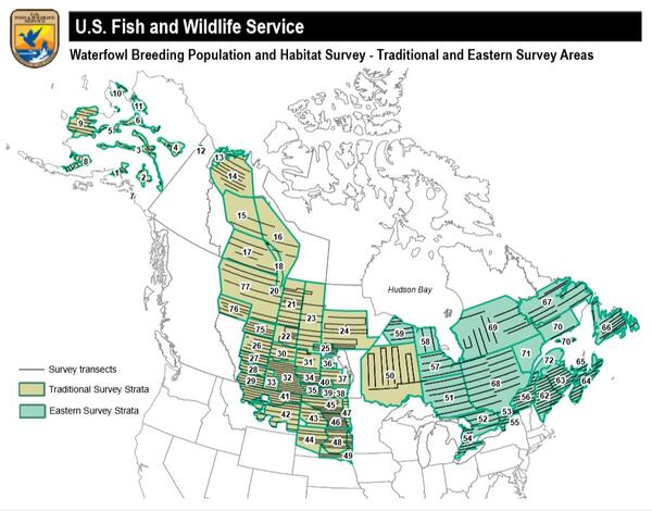
The Waterfowl Breeding Population and Habitat Survey (WBPHS) is the longest running broad-scale wildlife survey in the world. Results from the survey support migratory bird harvest management decision-making in Canada and the United States for most duck species, and some goose and swan populations. The WBPHS is divided into the Eastern Survey Area and the Traditional Survey Area, which differ in their methodology and in the way the data area analyzed. However, because the survey design, platforms and methodologies were not designed to be integrated across the two areas when the survey was established, current processes are not optimal in terms of survey protocols or analytical methods. Rising costs to conduct aerial surveys using fixed-wing aircraft and helicopters along with other process inefficiencies have prompted USGS and partners to explore how to redesign the Eastern Survey Area protocols.
What is at stake?
The US Migratory Bird Treaty Act (1918) and the Canadian Migratory Bird Conservation Act (1917) mandate that take of migratory gamebirds is prohibited unless it can be shown to be sustainable, an assessment that requires reliable information about bird abundance and distribution. The Canadian Wildlife Service (CWS) and U.S. Fish and Wildlife Service (USFWS) need to review and address issues related to the design, delivery, and long-term viability of the Eastern Survey Area to implement a cost-effective approach to securing the annual monitoring data these agencies rely on to set policies that safeguard sustainable harvest of North American waterfowl.
What is our approach?
In collaboration with CWS and USFWS, USGS is helping to develop and evaluate alternative monitoring designs, techniques, and methods for estimating the abundance of breeding waterfowl in Eastern Canada and the state of Maine. The primary focus of the redesigned survey is to estimate the abundance of breeding American black ducks (Anas rubripes) and other waterfowl species that share a similar breeding distribution and phenology (timing of events).
Primary project objectives include the following:
- Develop alternative design and methods for collecting data from the CWS helicopter and USFWS fixed-wing aircraft and analytical methods for analyzing the resulting data;
- Evaluate alternative designs and methodologies in terms of precision and bias relative to status quo design and operation for American black ducks and other priority eastern waterfowl species; and
- Calculate cost estimates for each alternative design and compare to status quo operations to quantify change in cost.
Researchers aim to simulate alternative aerial survey designs alone and in conjunction with other data streams such as those from the North American Breeding Bird Survey (BBS) and/or eBird. Simulations will be used to estimate data inputs, model performance, and changes in bias and precision relative to status quo design and operations. This project will also consider alternative analytical approaches to explore how to more effectively leverage detailed information (such as species identification of scoters, Melanitta sp.; mergansers, Mergus sp.; and scaup, Aythya sp.) that is collected through CWS helicopter surveys.
What are the benefits?
Lack of scientifically robust population data represents a significant impediment to agencies responsible for managing waterfowl. A revised Eastern Survey Area monitoring design will contribute to the long-term conservation of waterfowl, aid development of waterfowl hunting regulations, and support a more cost-effective approach to securing the bird abundance and distribution data these agencies require to make management decisions using the best available science.

Evaluating the Design of the Waterfowl Breeding Population and Habitat Survey

EESC Makes an Impact: Reducing Management Costs and Increasing Efficiency
USGS and partners are revising the design of a key waterfowl survey to increase management efficiency and cost-effectiveness, and inform annual harvest regulations in the U.S. and Canada.
What is the issue?
The Waterfowl Breeding Population and Habitat Survey (WBPHS) is the longest running broad-scale wildlife survey in the world. Results from the survey support migratory bird harvest management decision-making in Canada and the United States for most duck species, and some goose and swan populations. The WBPHS is divided into the Eastern Survey Area and the Traditional Survey Area, which differ in their methodology and in the way the data area analyzed. However, because the survey design, platforms and methodologies were not designed to be integrated across the two areas when the survey was established, current processes are not optimal in terms of survey protocols or analytical methods. Rising costs to conduct aerial surveys using fixed-wing aircraft and helicopters along with other process inefficiencies have prompted USGS and partners to explore how to redesign the Eastern Survey Area protocols.
What is at stake?
The US Migratory Bird Treaty Act (1918) and the Canadian Migratory Bird Conservation Act (1917) mandate that take of migratory gamebirds is prohibited unless it can be shown to be sustainable, an assessment that requires reliable information about bird abundance and distribution. The Canadian Wildlife Service (CWS) and U.S. Fish and Wildlife Service (USFWS) need to review and address issues related to the design, delivery, and long-term viability of the Eastern Survey Area to implement a cost-effective approach to securing the annual monitoring data these agencies rely on to set policies that safeguard sustainable harvest of North American waterfowl.
What is our approach?
In collaboration with CWS and USFWS, USGS is helping to develop and evaluate alternative monitoring designs, techniques, and methods for estimating the abundance of breeding waterfowl in Eastern Canada and the state of Maine. The primary focus of the redesigned survey is to estimate the abundance of breeding American black ducks (Anas rubripes) and other waterfowl species that share a similar breeding distribution and phenology (timing of events).
Primary project objectives include the following:
- Develop alternative design and methods for collecting data from the CWS helicopter and USFWS fixed-wing aircraft and analytical methods for analyzing the resulting data;
- Evaluate alternative designs and methodologies in terms of precision and bias relative to status quo design and operation for American black ducks and other priority eastern waterfowl species; and
- Calculate cost estimates for each alternative design and compare to status quo operations to quantify change in cost.
Researchers aim to simulate alternative aerial survey designs alone and in conjunction with other data streams such as those from the North American Breeding Bird Survey (BBS) and/or eBird. Simulations will be used to estimate data inputs, model performance, and changes in bias and precision relative to status quo design and operations. This project will also consider alternative analytical approaches to explore how to more effectively leverage detailed information (such as species identification of scoters, Melanitta sp.; mergansers, Mergus sp.; and scaup, Aythya sp.) that is collected through CWS helicopter surveys.
What are the benefits?
Lack of scientifically robust population data represents a significant impediment to agencies responsible for managing waterfowl. A revised Eastern Survey Area monitoring design will contribute to the long-term conservation of waterfowl, aid development of waterfowl hunting regulations, and support a more cost-effective approach to securing the bird abundance and distribution data these agencies require to make management decisions using the best available science.
Evaluating the Design of the Waterfowl Breeding Population and Habitat Survey