
CIDR Request Data – Request Details
CIDR Request Data – Request Details
The Request Data (link in the Menu bar) tool provides the option to assist U.S. Federal Civil agencies to enter near-term land remote sensing data requirements and provides an interface to place new Data Acquisition Requests (DARs). There are four sections within Request Data to acquire the desired data. Click information icon (i) for more definitions/information per entry box. (Figure 1)
The requirements for requesting data:
| Required | Optional |
|---|---|
| Active EROS Registration System Account Project Description/Justification Data Use and Sharing Archived Imagery Needed (Y/N) Type of Sensor Type of Product (MSI, PAN, SAR, Other) Acquisition Start Date Acquisition End Date Publicly Viewable DAR (Y/N) Collection Strategy Spatial Information | Spacecraft Processing Level Output Format |
A. Request Details
B. Imaging Requirements
C. Spatial Requirements
D. Submit Request
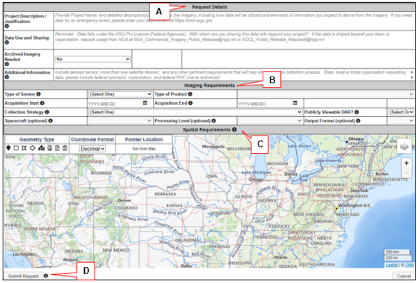
Figure 1: Request Data Tool
A. Request Details – Describe, with detail, the information about the data request. (Figure 2)
- Project Description/Justification
- Data Use and Sharing
- Archived Data Needed
- Has an Archived Data Scene List
- Additional Information
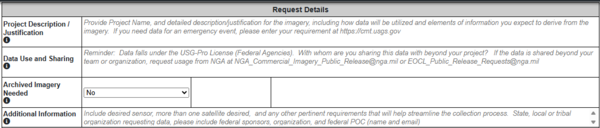
Figure 2: Request Details
Project Description/Justification - Provide Project Name, and detailed description/justification for the imagery, including how data will be utilized and elements of information you expect to derive from the imagery. If you need data for an emergency event, please enter your requirement at Collection Management Tool.
Data Use and Sharing - Whom are you sharing this data with? Will it be shared beyond your team or organization? Will the data support a publication or public product? The data may carry the restricted USG-Plus License:
- USG-Plus License
- Image sharing must support a US Government purpose, with a direct benefit for US Government
- New imagery or imagery derived products must contain copyright and USG-Plus license notice
- Sponsoring Federal Agencies must maintain US Government oversight of imagery distributed, end users, and downstream use
- US Federal Government employee or person authorized by a US Federal Government agency must authorize contractors, temporary users, and volunteers registering to use imagery
Archived Data Needed – Applies to MAXAR data archived in their Discovery or Global Enhanced GEOINT Delivery site (GEGD-Pro).
Has an Archived Data Scene List – Users looking for archived data (MAXAR), search Discovery Tool or Global Enhanced GEOINT Delivery site (GEGD-Pro) and provide list of desired scenes. For large lists, email text file to cidr@usgs.gov.
Additional Information – Include desired sensor, more than one satellite, and any other pertinent requirements that will help streamline the collection process. State, local or tribal organization requesting data, please include federal sponsors, organization, and federal POC (name and email).
CIDR Request Data – Request Details
The Request Data (link in the Menu bar) tool provides the option to assist U.S. Federal Civil agencies to enter near-term land remote sensing data requirements and provides an interface to place new Data Acquisition Requests (DARs). There are four sections within Request Data to acquire the desired data. Click information icon (i) for more definitions/information per entry box. (Figure 1)
The requirements for requesting data:
| Required | Optional |
|---|---|
| Active EROS Registration System Account Project Description/Justification Data Use and Sharing Archived Imagery Needed (Y/N) Type of Sensor Type of Product (MSI, PAN, SAR, Other) Acquisition Start Date Acquisition End Date Publicly Viewable DAR (Y/N) Collection Strategy Spatial Information | Spacecraft Processing Level Output Format |
A. Request Details
B. Imaging Requirements
C. Spatial Requirements
D. Submit Request
Figure 1: Request Data Tool
A. Request Details – Describe, with detail, the information about the data request. (Figure 2)
- Project Description/Justification
- Data Use and Sharing
- Archived Data Needed
- Has an Archived Data Scene List
- Additional Information
Figure 2: Request Details
Project Description/Justification - Provide Project Name, and detailed description/justification for the imagery, including how data will be utilized and elements of information you expect to derive from the imagery. If you need data for an emergency event, please enter your requirement at Collection Management Tool.
Data Use and Sharing - Whom are you sharing this data with? Will it be shared beyond your team or organization? Will the data support a publication or public product? The data may carry the restricted USG-Plus License:
- USG-Plus License
- Image sharing must support a US Government purpose, with a direct benefit for US Government
- New imagery or imagery derived products must contain copyright and USG-Plus license notice
- Sponsoring Federal Agencies must maintain US Government oversight of imagery distributed, end users, and downstream use
- US Federal Government employee or person authorized by a US Federal Government agency must authorize contractors, temporary users, and volunteers registering to use imagery
Archived Data Needed – Applies to MAXAR data archived in their Discovery or Global Enhanced GEOINT Delivery site (GEGD-Pro).
Has an Archived Data Scene List – Users looking for archived data (MAXAR), search Discovery Tool or Global Enhanced GEOINT Delivery site (GEGD-Pro) and provide list of desired scenes. For large lists, email text file to cidr@usgs.gov.
Additional Information – Include desired sensor, more than one satellite, and any other pertinent requirements that will help streamline the collection process. State, local or tribal organization requesting data, please include federal sponsors, organization, and federal POC (name and email).