
USGS EROS Archive - Landsat Legacy - Landsat 4-8 C1 U.S. ARD Sample
Landsat Collection 1 Legacy Samples preserve a selection of data from the first Landsat Collection. These samples provide essential benchmarks for researchers, ensuring historical data remains available for comparison and can be used to evaluate quality improvements across collections.
Dataset Citation
Please cite this dataset in the following manner:
Earth Resources Observation and Science (EROS) Center. Landsat Level-2 United States Analysis Ready Data, Collection 1 Legacy Sample [dataset]. U.S. Geological Survey. https://doi.org/10.5066/P13NEQFA
Purpose of Legacy Samples
A subset of Landsat 1-8 Collection 1 products have been selected and retained to support science quality assessment, data processing algorithm chain testing, and cross-collection comparisons. Landsat Level-1 products, U.S. Analysis Ready Data (ARD), and operational Level-3 products are included in the Collection 1 Legacy Samples.
Note: Landsat Collection 1 products were removed from public access in December 2022. These Collection 1 Legacy Samples are intended for software testing and cross-collection comparison only. Please use Landsat Collection 2 products for current scientific studies.
Location Selection Rationale
The locations of the Legacy Samples were selected based on atmospheric and surface conditions – most notably, at proven instrumented reference test sites where regular in-situ calibration measurements are available. Coastal and inland water locations, as well as areas of recurring data anomalies were also included. Additionally, random samples were selected to represent a proportional ratio to the total available products from each Landsat sensor.
The following criteria was established for inclusion in Landsat Collection 1 Legacy Samples:
- Represent a percentage of data from each satellite sensor.
- Ensure global distribution as evenly as possible.
- Include validation products that enable regeneration of satellite calibrations required to maintain a record for cross-collection comparisons (e.g. geometric and radiometric accuracy, atmospheric compensation).
- Include products that cross the Antemeridian (+/-180-degree Longitude), products designated for future U.S. ARD testing, and products in areas known to cause ground systems issues so they can be identified and addressed during future ground system software development.
- Include random products for testing system bulk processing.
Legacy Samples Product Overview
U.S. Analysis Ready Data (ARD)
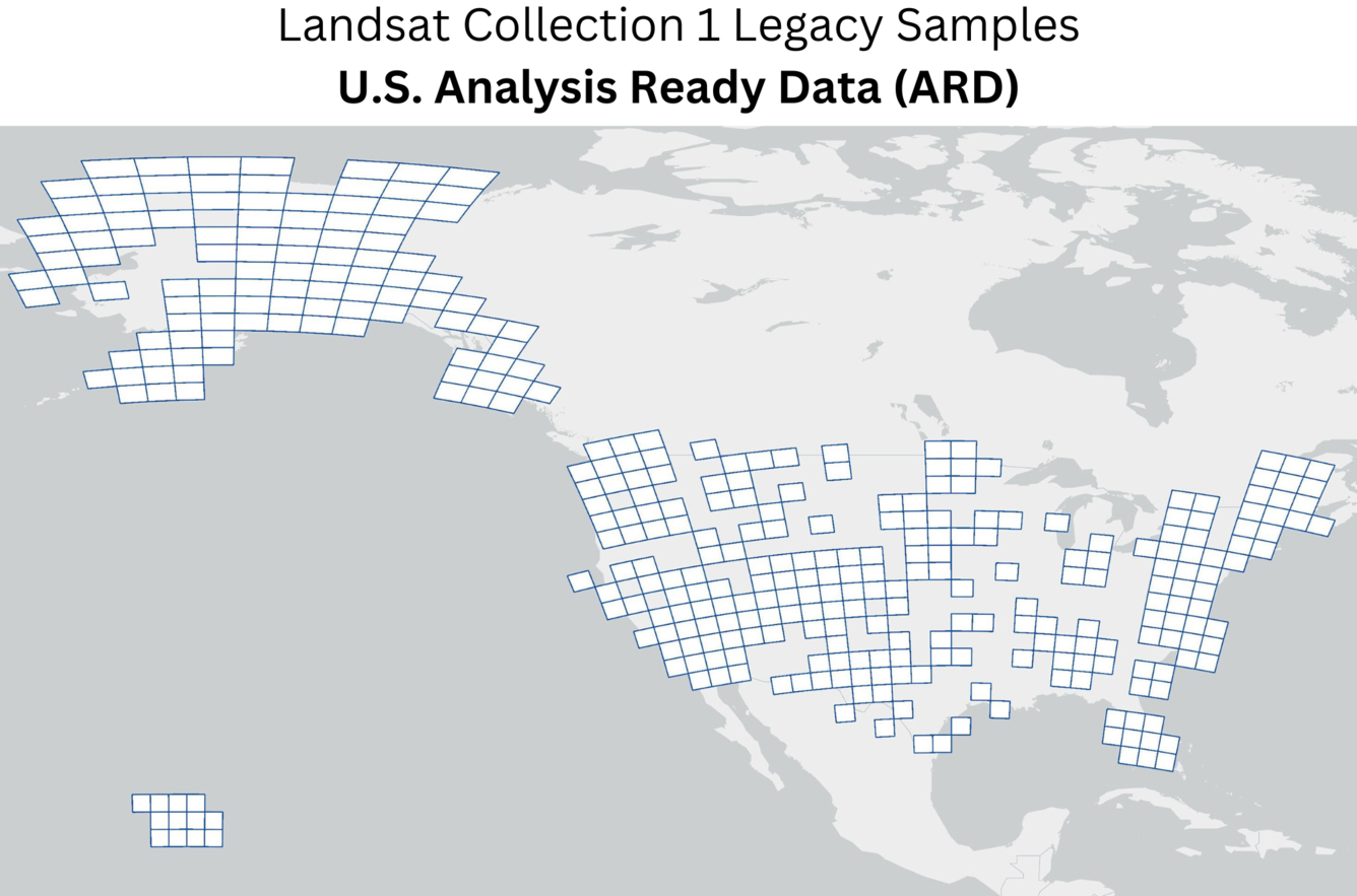
U.S. ARD products are organized into tiles, which are uniform units bounded by static corner points in a defined grid system. Since tile-based products are useful for time-series analysis, one tile was selected to provide an entire data 'stack' for additional testing and research. Landsat Collection 1 U.S. ARD products were generated from Landsat 4-5 TM, Landsat 7 ETM+, and Landsat 8 OLI/TIRS data.
- Over 70% of the 4,574 U.S. ARD products selected contain data from one Conterminous U.S. (CONUS) tile west of Denver, Colorado. (H011V009).
- The remaining 30% included areas that will be used for future U.S. ARD product testing.
Additional Information
- Landsat Missions Web Site: Landsat Collection Legacy Samples
Access Data
The Landsat Level-2 United States Analysis Ready Data, Collection 1 Legacy Sample are available for download from EarthExplorer.
The data are located under the "Landsat" category, "Landsat Legacy subcategory", as "Landsat 4-8 C1 U.S. ARD Sample".
After reviewing the search results and selecting a scene, users will be able to download data. The USGS Landsat no-cost and open data policy remains intact since its inception in 2008.
Landsat Collection 1 Legacy Samples preserve a selection of data from the first Landsat Collection. These samples provide essential benchmarks for researchers, ensuring historical data remains available for comparison and can be used to evaluate quality improvements across collections.
Dataset Citation
Please cite this dataset in the following manner:
Earth Resources Observation and Science (EROS) Center. Landsat Level-2 United States Analysis Ready Data, Collection 1 Legacy Sample [dataset]. U.S. Geological Survey. https://doi.org/10.5066/P13NEQFA
Purpose of Legacy Samples
A subset of Landsat 1-8 Collection 1 products have been selected and retained to support science quality assessment, data processing algorithm chain testing, and cross-collection comparisons. Landsat Level-1 products, U.S. Analysis Ready Data (ARD), and operational Level-3 products are included in the Collection 1 Legacy Samples.
Note: Landsat Collection 1 products were removed from public access in December 2022. These Collection 1 Legacy Samples are intended for software testing and cross-collection comparison only. Please use Landsat Collection 2 products for current scientific studies.
Location Selection Rationale
The locations of the Legacy Samples were selected based on atmospheric and surface conditions – most notably, at proven instrumented reference test sites where regular in-situ calibration measurements are available. Coastal and inland water locations, as well as areas of recurring data anomalies were also included. Additionally, random samples were selected to represent a proportional ratio to the total available products from each Landsat sensor.
The following criteria was established for inclusion in Landsat Collection 1 Legacy Samples:
- Represent a percentage of data from each satellite sensor.
- Ensure global distribution as evenly as possible.
- Include validation products that enable regeneration of satellite calibrations required to maintain a record for cross-collection comparisons (e.g. geometric and radiometric accuracy, atmospheric compensation).
- Include products that cross the Antemeridian (+/-180-degree Longitude), products designated for future U.S. ARD testing, and products in areas known to cause ground systems issues so they can be identified and addressed during future ground system software development.
- Include random products for testing system bulk processing.
Legacy Samples Product Overview
U.S. Analysis Ready Data (ARD)
U.S. ARD products are organized into tiles, which are uniform units bounded by static corner points in a defined grid system. Since tile-based products are useful for time-series analysis, one tile was selected to provide an entire data 'stack' for additional testing and research. Landsat Collection 1 U.S. ARD products were generated from Landsat 4-5 TM, Landsat 7 ETM+, and Landsat 8 OLI/TIRS data.
- Over 70% of the 4,574 U.S. ARD products selected contain data from one Conterminous U.S. (CONUS) tile west of Denver, Colorado. (H011V009).
- The remaining 30% included areas that will be used for future U.S. ARD product testing.
Additional Information
- Landsat Missions Web Site: Landsat Collection Legacy Samples
Access Data
The Landsat Level-2 United States Analysis Ready Data, Collection 1 Legacy Sample are available for download from EarthExplorer.
The data are located under the "Landsat" category, "Landsat Legacy subcategory", as "Landsat 4-8 C1 U.S. ARD Sample".
After reviewing the search results and selecting a scene, users will be able to download data. The USGS Landsat no-cost and open data policy remains intact since its inception in 2008.