
Hydrologic Research
Hydrologic Research
The NVWSC scientists are developing state-of-the-art methods for water quantity and quality assessments, predictive hydrologic models that are key to evaluating future responses of the water cycle to climate change, water resource assessments instrumental to policy makers for clearly weighing the competing energy alternatives and evaluating the environmental cost for energy development, and water-quality monitoring to detect emerging and other drinking-water contaminants that pose a risk to public health.
Filter Total Items: 53
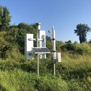
Next Generation Water Observing System (NGWOS) - Advancing Soil Moisture Monitoring
Soil moisture is an important part of the climate system, but it remains difficult to measure accurately. In 2022, the U.S. Geological Survey (USGS) began building a soil moisture monitoring network to provide high-quality continuous soil moisture data, standardize data collection methods, and test new technologies. Stations are placed in different climates and land cover types to capture a broad...

Science in the Humboldt River Basin
The Humboldt River flows east to west through north-central Nevada and is about 330 miles long. It is an important water source for residents and agriculture, and it also supports one of Nevada’s largest industries—gold mining. Most of the state’s mines are in the Humboldt River Basin along the Carlin Trend. Nevada produces about 72 percent of all U.S. gold, making it the fifth largest producer in...

Science in the Colorado River Basin
The Colorado River is one of the longest rivers in the Western United States. It begins in the Rocky Mountains of Colorado and flows southwestward until it reaches Mexico where it becomes a small stream or dry riverbed. The Colorado River forms the border between southeastern Nevada and northwestern Arizona. In Nevada, Hoover Dam and Davis Dam control the flow of the river and create two...

Measurements of Stream Discharge and Analysis of Surface Water/Groundwater Interactions in Las Vegas Wash, Las Vegas, NV
The Black Mountain Industrial (BMI) complex, in Henderson, Nevada, has been the site of industrial chemical production since 1942. Perchlorate contaminants, from activities at BMI, have moved through the groundwater system and have been discovered in the Las Vegas Wash, prompting water resource investigations and groundwater treatment by the Nevada Division of Environmental Protection (NDEP). The...

Estimating Annual Groundwater Discharge by Evapotranspiration Along the Wild and Scenic Portion of the Amargosa River
The USGS Nevada Water Science Center is refining estimates of annual groundwater discharge along the Wild and Scenic portion of the Amargosa River (AWSR) and adjacent spring discharge areas. Discharge estimates will be based on evapotranspiration (ET) measurements made along the Amargosa River during a 2-year period, previous estimates of evapotranspiration rates, and remote sensing techniques...

Monitoring Hydrogeologic Conditions in the Regional Carbonate Aquifer, Clark County, Nevada
The USGS Nevada Water Science Center is evaluating and enhancing our current understanding of the hydrologic condition of the regional groundwater flow system in Clark County, Nevada. In order to achieve this objective, monitoring wells were installed in consolidated bedrock in six select regions throughout Clark County. Water-level, elevation, and borehole geophysical data were synthesized and...

Water Quality of Springs in the Spring Mountains
The USGS Nevada Water Science Center, in cooperation with the Bureau of Land Management, is sampling and analyzing water from Grapevine, Kiup, and Rainbow Springs to determine the source of water to these springs. These Springs, located in the Spring Mountains in southern Nevada, provide habitat for endangered spring snail species including the southeast Nevada Pyrg (Pyrgulopsis turbatrix) and the...

Monitoring Sediment and Water Quality in Clear Creek
Clear Creek is a small alpine stream that begins near Lake Tahoe in the Sierra Nevada. The creek flows roughly parallel to U.S. Highway 50 and discharges to the Carson River near Carson City, Nevada. The Nevada Department of Transportation (NDOT) is concerned about how historical and ongoing development in the Clear Creek drainage basin has/is affecting Clear Creek and its sediment-transport...

Drought in Nevada
Ongoing drought, in Nevada and across the West, will require scientists to develop new ideas and techniques for measuring, monitoring, modeling, and managing water resources. NVWSC has the capabilities to meet these challenges with our extensive scientific expertise in data collection, modeling, and research. We also are creating new ways to provide data to the public and stakeholders through...

Quantifying watershed controls on fine sediment particles and nutrient loading to Lake Tahoe using data mining and machine learning
Since the late 1980’s, the USGS has collected discharge, sediment, and water quality data at seven major drainages under the Lake Tahoe Interagency Monitoring Program (LTIMP). Recently, continuous, real-time measurements of turbidity were added to the LTIMP. These data can be combined with in situ, model simulations, and remotely-sensed datasets available from the USGS, National Aeronautics and...

Aquifer Tests in Nevada
Many aquifer tests have been conducted by the U.S. Geological Survey to estimate hydraulic properties of aquifers in Nevada and adjacent states. Transmissivity is the principal hydraulic property that has been estimated from the aquifer tests in Nevada because these values directly affect estimates of ground-water flow.

Floods in Nevada
For more than 100 years, the USGS has played a critical role in reducing flood losses by operating a nationwide streamgage network that monitors the water level and flow of the Nation's rivers and streams. Through satellite and computer technology, streamgages transmit real-time information, which the National Weather Service (NWS) uses to issue flood warnings.