



USGS Launches Interactive Streamflow Map Tools
The U.S. Geological Survey New England Water Science Center launched two new web applications that use color to indicate the status of certain water conditions at USGS streamgages. Both web tools are colorful, interactive maps that visually depict whether a gage is above or below typical water levels or within certain state-required baseflow limits.
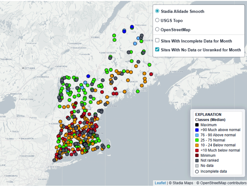
Monthly Streamflow Conditions in New England
The “Monthly Streamflow Conditions in New England” application is a regional map that displays USGS streamgages. Each identified streamgage is colored to indicate its monthly streamflows– whether the water levels were higher or lower than is usually recorded at that gage for that month. This color-coding allows the public and decision makers to determine drought and flood risk or identify irregular flows by quickly assessing how current monthly streamflows compare to their long-term monthly statistics.
This interactive map indicates if the streamgage’s mean or median streamflow value for a selected month is considered “normal”, “above normal”, or “below normal” in relation to that site’s long-term record and to what degree. Through color, users can easily see whether the selected streamflow statistics sit in the higher, lower, or middle percentiles for that site’s collected data, with red and orange representing below normal, green showing normal conditions, and light to dark blue indicating above normal water levels.
Water managers in multiple levels of government and across the public and private sectors in New England can use this tool to define drought or flood severity in any given month relative to historical streamflow levels. For instance, these data are vital in the implementation of state drought plans that rely on monthly statistics.
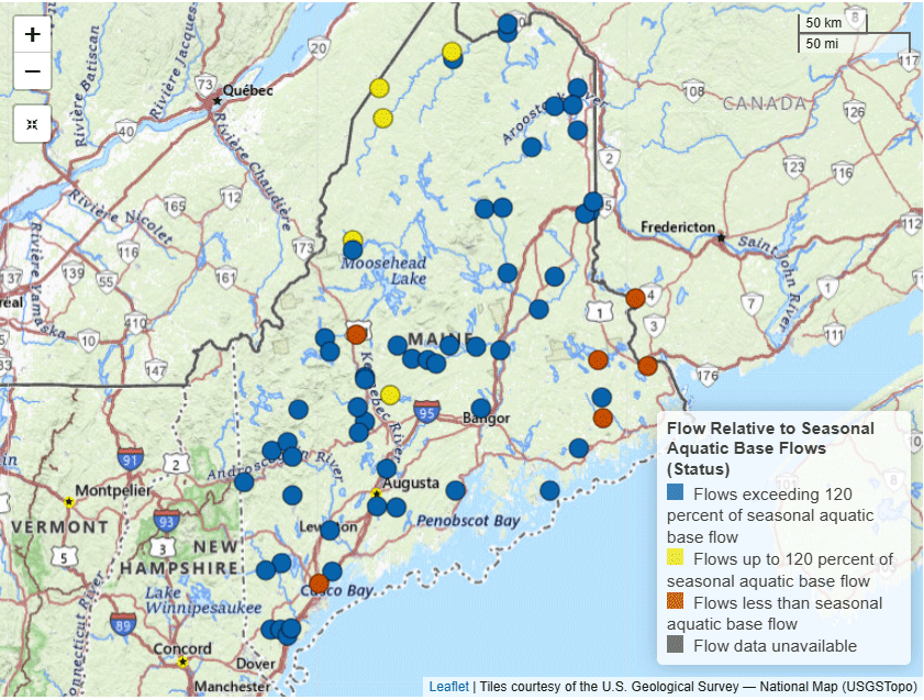
Comparison of Streamflow in Maine to Seasonal Aquatic Base Flow
The USGS New England Water Science Center has published a new web application to help visualize streamflows at Maine streamgages in relation to seasonal aquatic baseflow standards set by the state.
Maine’s “In-stream Flows and Lake and Pond Water Levels Rule” establishes set streamflow and water levels for lakes and ponds to preserve aquatic life. Any activity that could alter the volume of water in the state’s water bodies, such as withdrawals or diversions, must abide by these streamflow and water level requirements. The regulation sets seasonal aquatic base flows that define the median streamflows for winter, spring, early summer, summer, fall, and early winter.
USGS’ new interactive map lets users visualize current streamflows in comparison to these seasonal aquatic baseflow standards through color at each site. The various colors indicate whether flows are equal to, less than, or more than 120% of the seasonal aquatic baseflow. This capability provides water managers with an immediate visualization of how current streamflows compare to Maine’s legally required baseflows to see if there is any ecological risk or management action needed.
These new tools can be found on our New England Water Conditions Explorer page.
Related
New England Water Conditions Explorer
Related