
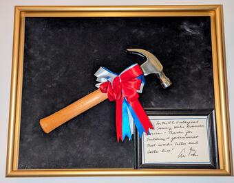
In 1996 the USGS Water Resources Division (now called Water Mission Area) received Vice President Gore's Hammer Award. It was presented by Assistant Secretary for Water and Science, Patricia Beneke, at the Carnegie Center in Oregon City, Oregon, with Dennis Lynch, District Chief, Oregon, accepting on behalf of the Division.
USGS Oregon Water Science Center remembers the 1996 flood
By Oregon Water Science Center
February 2, 2026
In February 1996, one of the Pacific Northwest’s most devastating floods of the 20th century struck the region. The U.S. Geological Survey’s rapid response helped protect communities and earned national recognition.
The 1996 Flood: A Look Back
The February 1996 flood stands out as one of the most destructive events of the 20th century for Northwest Oregon and the surrounding areas. A winter of deep snow and ice gave way to an atmospheric river that drenched the Willamette Valley with warm rain. Rivers swelled beyond recognition, swallowing landmarks and turning streets into waterways.
Large areas of the region were under threat, including coastal communities and Oregon’s most populated cities from Corvallis to Portland. Residents boated down roads in Oregon City, livestock were lost in Tillamook County, and volunteers lined Portland’s waterfront with sandbags to keep the Willamette River from flooding downtown. The flood claimed eight lives in Oregon, three in Washington, and destroyed property. For those who lived and worked through it, the flood was unforgettable. This was a moment when nature’s force met human resilience.
By January 31, snowpack in Oregon’s mountains was well above average. Then came an intense cold snap, freezing the soil. When the warm atmospheric river arrived in early February, heavy rain fell on a saturated, frozen landscape. Rivers rose rapidly between February 6–9, cresting far above flood stage:
- Willamette River at Portland: 10 feet above flood stage
- Columbia River at Vancouver: 10 feet above flood stage
- Clackamas River: 7 feet above flood stage
- Nehalem River at Foss: 13 feet above flood stage
- Tualatin River: 5 feet above flood stage
Roads closed statewide including 180 points on state highways alone. Both major interstate highways shut down in places. Access to numerous streamflow gaging stations was nearly impossible, yet the need for data was urgent.

Sources/Usage: Public Domain. View Media Details
USGS in action
When the waters rose, USGS crews mobilized. “It was like triage for three days,” recalled hydrologic technician Mike Sarantou. “Day 1 was creeks and small streams, Johnson Creek, Fanno Creek. Day 2 was larger rivers like the Clackamas and Tualatin. Day 3 was all Willamette, trying to catch the peak as it moved through the valley.”
Fieldwork was grueling and dangerous. At Johnson Creek, Sarantou waded into a gage house nearly underwater. On the Willamette River at Albany, he piloted a 16-foot boat through a flooded park to reach the launch—20 feet underwater. “Driving that boat at the peak of the flood was the scariest moment of my career,” he said. “Debris everywhere. It was like bumper cars.”
Others faced similar challenges. Karl Lee, USGS hydrologist, found gages on Oregon coastal rivers offline. Five days after the Nehalem River peak, he untangled tree debris on the gage walkway, found the stilling well silted in, and noted the river had been inches from the instrument shelf. He wrote, “The river, having receded some 20 feet from the peak, was calm, and the entire reach had that damp, musty smell you never forget.”
Media
When Karl Lee and Mark Uhrich arrived to make a flow measurement, they found that the high-water left behind a significant debris pile at the Nehalem River near Foss, Oregon gage house. View the data from this historic flood.
Sources/Usage: Public Domain. View Media Details
Media
USGS technicians, Len Reed and Mike DeVolder, measuring the flood peak on the Tualatin River at West Linn on February 10, 1996. View the data from this historic flood.
Sources/Usage: Public Domain. View Media Details
Collaboration and Communication
Behind the scenes, coordination was critical. USGS worked closely with the National Weather Service and the U.S. Army Corps of Engineers. “It was a symbiotic relationship,” noted then Portland Field Office Chief, Tom Herrett about working with National Weather Service. “They depended on us for real-time data; we depended on their forecasts to know where to measure.”
Data flowed to emergency managers and the public through National Oceanic and Atmospheric Administration radio and the newly established USGS website. The February 1996 flood was one of the first events to show the value of having USGS data online. More than 30,000 internet connections accessed Oregon and Washington USGS streamflow pages during the flood, a milestone in public service. USGS data was the basis for dozens of decisions regarding evacuations and safe-guarding property.
Media
Sources/Usage: Public Domain. View Media Details
Legacy
The timely advancement of publicly available real-time data and USGS response in Oregon earned national recognition. Vice President Gore’s Hammer Award honored the entire Water Resources Division (now called the Water Mission Area) for innovation and efficiency. Presented in Oregon City, the award symbolized a moment of pride for government service.
According to the USGS Hammer Award memo, the efforts of the team to provide critically needed information saved many lives and averted an estimated \$2.7 billion in flood damage.
The February 1996 flood left its mark on USGS operations. About 10 percent of Oregon gaging stations suffered major damage; repairs and upgrades followed. Stilling wells gave way to pressure sensors. Structures were raised and flood hardened. In later years, USGS in Oregon led the way converting to more frequent transmissions of river levels, enhancing real-time data delivery to the public.
In 1996, acoustic measurements were cutting-edge. Today, USGS uses satellite telemetry, real-time dashboards, and even drones to measure surface water speeds during floods.
The flood of February 1996 was more than a natural disaster; it was a test of ingenuity and resolve. USGS rose to the challenge, delivering data that guided life-saving decisions and helped shape the future of flood science. As rivers rise again in years to come, the legacy of that winter endures as a reminder that behind every USGS hydrograph is a team ready to brave the storm.
Related
Images from the flood event.
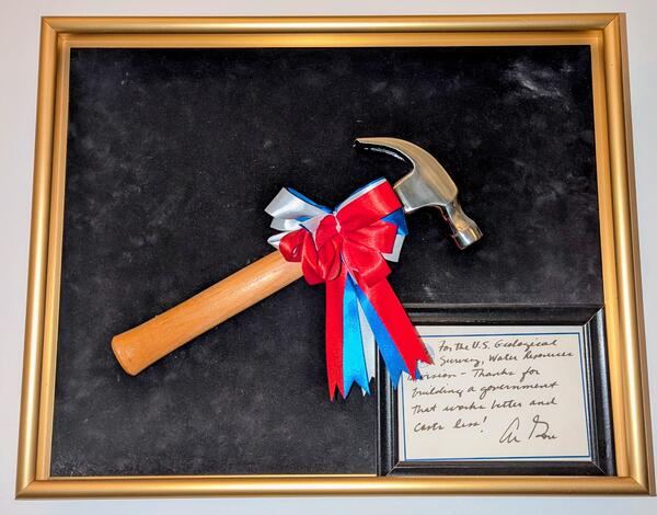
USGS Oregon District Hammer Award
In 1996 the USGS Water Resources Division (now called Water Mission Area) received Vice President Gore's Hammer Award. It was presented by Assistant Secretary for Water and Science, Patricia Beneke, at the Carnegie Center in Oregon City, Oregon, with Dennis Lynch, District Chief, Oregon, accepting on behalf of the Division.

High water sign on Tualatin River, OR
Lower Tualatin River near Cook Park, OR. Signage on the top of the wood pole shows high water line of the 1996 flood.
Lower Tualatin River near Cook Park, OR. Signage on the top of the wood pole shows high water line of the 1996 flood.

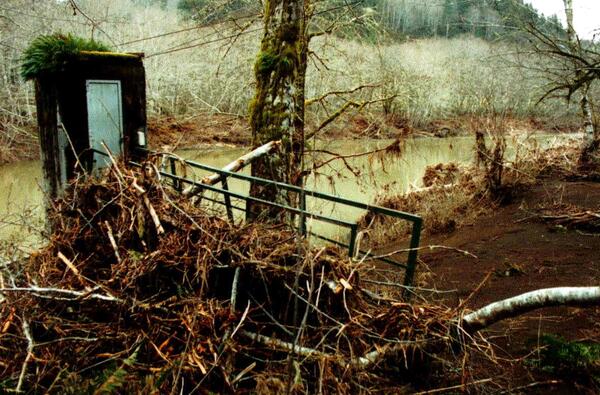
1996 Flood: Nehalem River near Foss, Oregon
When Karl Lee and Mark Uhrich arrived to make a flow measurement, they found that the high-water left behind a significant debris pile at the Nehalem River near Foss, Oregon gage house.
When Karl Lee and Mark Uhrich arrived to make a flow measurement, they found that the high-water left behind a significant debris pile at the Nehalem River near Foss, Oregon gage house.

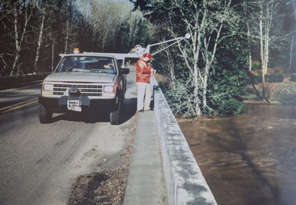
Historic photo of Tualatin River at West Linn
USGS technicians, Len Reed and Mike DeVolder, measuring the flood peak on the Tualatin River at West Linn on February 10, 1996.
USGS technicians, Len Reed and Mike DeVolder, measuring the flood peak on the Tualatin River at West Linn on February 10, 1996.
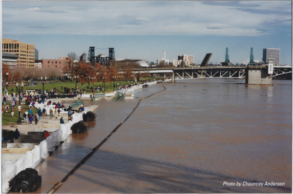
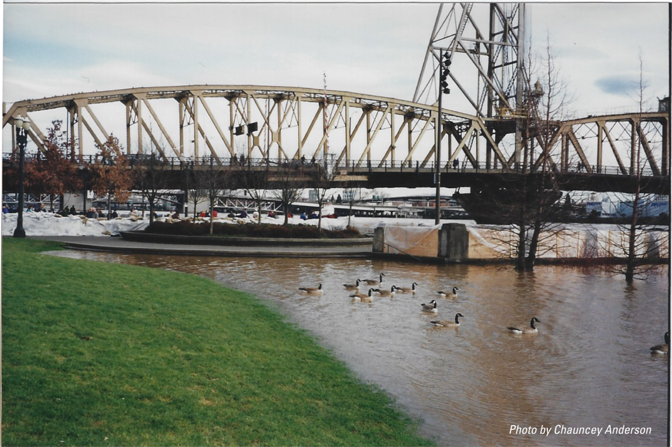
1996 Flood: Willamette River Portland Waterfront
A 1996 flood photo depicts the swollen Willamette River at Tom McCall Waterfront Park in downtown Portland, Oregon, during the region's most destructive flood since 1964. The left side shows a wall of sandbags, wood, and jersey barriers, successfully protecting the downtown area. Iconic city bridges span the background.
A 1996 flood photo depicts the swollen Willamette River at Tom McCall Waterfront Park in downtown Portland, Oregon, during the region's most destructive flood since 1964. The left side shows a wall of sandbags, wood, and jersey barriers, successfully protecting the downtown area. Iconic city bridges span the background.

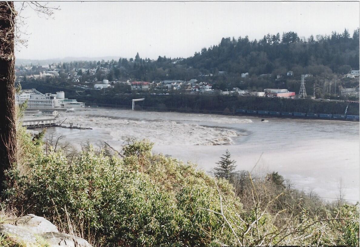
1996 flood: Willamette Falls, Oregon City
Willamette Falls during the February 1996 flood. The falls, usually about 12 meters high in a horseshoe shape, were reduced to a small riffle.
Willamette Falls during the February 1996 flood. The falls, usually about 12 meters high in a horseshoe shape, were reduced to a small riffle.
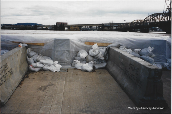
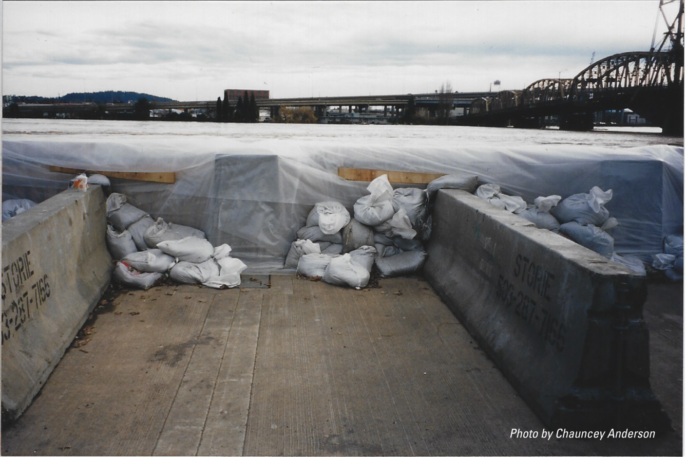
1996: Temporary levee dubbed "Vera's Wall"
In February 1996, as the Willamette River threatened downtown Portland, Mayor Vera Katz rallied over 1,500 volunteers to build "Vera's Wall". This mile-long, four-foot-high temporary levee, made of 40,000 sandbags, plywood, and jersey barriers, was hastily constructed atop the existing seawall in just 24 hours and successfully held back the floodwaters.
In February 1996, as the Willamette River threatened downtown Portland, Mayor Vera Katz rallied over 1,500 volunteers to build "Vera's Wall". This mile-long, four-foot-high temporary levee, made of 40,000 sandbags, plywood, and jersey barriers, was hastily constructed atop the existing seawall in just 24 hours and successfully held back the floodwaters.

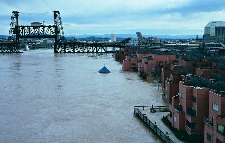
1996 Flood: Portland's Steel Bridge
This photo shows the Willamette River at its peak flood stage in February 1996, a major event for the Pacific Northwest. The river reached the very bottom of the Steel Bridge's lower deck, leading to the bridge being closed to all traffic as a safety precaution for nearly 48 hours.
This photo shows the Willamette River at its peak flood stage in February 1996, a major event for the Pacific Northwest. The river reached the very bottom of the Steel Bridge's lower deck, leading to the bridge being closed to all traffic as a safety precaution for nearly 48 hours.
Related
Images from the flood event.
USGS Oregon District Hammer Award
In 1996 the USGS Water Resources Division (now called Water Mission Area) received Vice President Gore's Hammer Award. It was presented by Assistant Secretary for Water and Science, Patricia Beneke, at the Carnegie Center in Oregon City, Oregon, with Dennis Lynch, District Chief, Oregon, accepting on behalf of the Division.
In 1996 the USGS Water Resources Division (now called Water Mission Area) received Vice President Gore's Hammer Award. It was presented by Assistant Secretary for Water and Science, Patricia Beneke, at the Carnegie Center in Oregon City, Oregon, with Dennis Lynch, District Chief, Oregon, accepting on behalf of the Division.
High water sign on Tualatin River, OR
Lower Tualatin River near Cook Park, OR. Signage on the top of the wood pole shows high water line of the 1996 flood.
Lower Tualatin River near Cook Park, OR. Signage on the top of the wood pole shows high water line of the 1996 flood.
1996 Flood: Nehalem River near Foss, Oregon
When Karl Lee and Mark Uhrich arrived to make a flow measurement, they found that the high-water left behind a significant debris pile at the Nehalem River near Foss, Oregon gage house.
When Karl Lee and Mark Uhrich arrived to make a flow measurement, they found that the high-water left behind a significant debris pile at the Nehalem River near Foss, Oregon gage house.
Historic photo of Tualatin River at West Linn
USGS technicians, Len Reed and Mike DeVolder, measuring the flood peak on the Tualatin River at West Linn on February 10, 1996.
USGS technicians, Len Reed and Mike DeVolder, measuring the flood peak on the Tualatin River at West Linn on February 10, 1996.
1996 Flood: Willamette River Portland Waterfront
A 1996 flood photo depicts the swollen Willamette River at Tom McCall Waterfront Park in downtown Portland, Oregon, during the region's most destructive flood since 1964. The left side shows a wall of sandbags, wood, and jersey barriers, successfully protecting the downtown area. Iconic city bridges span the background.
A 1996 flood photo depicts the swollen Willamette River at Tom McCall Waterfront Park in downtown Portland, Oregon, during the region's most destructive flood since 1964. The left side shows a wall of sandbags, wood, and jersey barriers, successfully protecting the downtown area. Iconic city bridges span the background.
1996 flood: Willamette Falls, Oregon City
Willamette Falls during the February 1996 flood. The falls, usually about 12 meters high in a horseshoe shape, were reduced to a small riffle.
Willamette Falls during the February 1996 flood. The falls, usually about 12 meters high in a horseshoe shape, were reduced to a small riffle.
1996: Temporary levee dubbed "Vera's Wall"
In February 1996, as the Willamette River threatened downtown Portland, Mayor Vera Katz rallied over 1,500 volunteers to build "Vera's Wall". This mile-long, four-foot-high temporary levee, made of 40,000 sandbags, plywood, and jersey barriers, was hastily constructed atop the existing seawall in just 24 hours and successfully held back the floodwaters.
In February 1996, as the Willamette River threatened downtown Portland, Mayor Vera Katz rallied over 1,500 volunteers to build "Vera's Wall". This mile-long, four-foot-high temporary levee, made of 40,000 sandbags, plywood, and jersey barriers, was hastily constructed atop the existing seawall in just 24 hours and successfully held back the floodwaters.
1996 Flood: Portland's Steel Bridge
This photo shows the Willamette River at its peak flood stage in February 1996, a major event for the Pacific Northwest. The river reached the very bottom of the Steel Bridge's lower deck, leading to the bridge being closed to all traffic as a safety precaution for nearly 48 hours.
This photo shows the Willamette River at its peak flood stage in February 1996, a major event for the Pacific Northwest. The river reached the very bottom of the Steel Bridge's lower deck, leading to the bridge being closed to all traffic as a safety precaution for nearly 48 hours.