
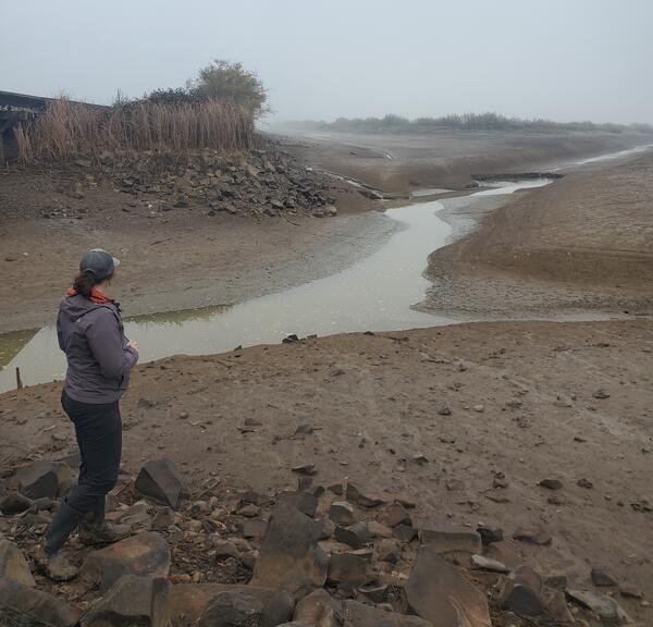
USGS Hydrologist is looking at a headcut/headward erosion/knickpoint in thr center-right of photo during field effort to verify geomorphic mapping.
The USGS, in cooperation with the U.S. Army Corps of Engineers (USACE), is conducting targeted research to better understand geomorphic conditions and processes within the reservoir at Fern Ridge Lake, near Eugene, Oregon, so that managers have the information to support dam operations and other actions that will aid in the preservation and management of cultural sites.
Background:
Media
Sources/Usage: Public Domain. View Media Details
Construction and operation of large reservoirs in the Willamette Valley can affect important cultural, biological, and other natural or economic resources. Fern Ridge Dam, in the Willamette Valley west of Eugene, Oregon, was constructed by the USACE in 1941. Fern Ridge Dam transformed the Long Tom River and surrounding landscape from a broad valley with wetlands and small streams into a shallow reservoir (called Fern Ridge Lake) that is shaped by complex patterns of sediment erosion, deposition, and transport. Fern Ridge Dam was the first of 13 multi-purpose dams in the Willamette Valley that were built to reduce flood risks to downstream communities and provide other benefits such as stored water for irrigation and reservoir-based recreation. Dam operators manage reservoir levels to meet these purposes, and as a result reservoir levels can fluctuate annually by more than 20 feet exposing about 7,400 acres of reservoir bed between minimum and maximum pool levels.
As the reservoir levels rise and fall throughout the year, the areas where sediment builds-up or erodes changes. These changes are influenced by the seasonal flow of streams in the watershed and the amount of sediment they carry into the reservoir, as well as how the reservoir levels are operated.
Why this matters:
Support information for management and preservation of cultural resource sites: The Willamette Valley and the areas within and around the Fern Ridge Lake encompass a landscape that has been used by pre-contact peoples to early historical settlers. As a result, there are widespread and numerous cultural resource sites and archaeological artifacts within and around Fern Ridge Lake which are subject to dynamic erosion and deposition processes influenced by reservoir management.
Support other reservoirs and dam purposes: Results of this study can be used to inform flood-risk management, habitat and wildlife needs, recreation, and infrastructure to ensure the long-term sustainability for ecologically and economically important reservoirs in the Willamette Valley.
Support USGS mission: This effort also supports the USGS core mission of providing reliable data and scientific information to support management of the Nation’s water resources.
Primary objectives:
1) Evaluate geomorphic processes within Fern Ridge Lake and its tributaries with a specific focus on understanding areas, magnitudes, and future trajectories of erosion and deposition to inform cultural resource management questions.
2) Develop a geomorphic framework of landforms and geomorphic processes at Fern Ridge Lake that reflects local geology, pre-dam geomorphology, erosion and deposition, streamflow, flood risk management operations, and other controls.
Images taken during field work.

Fern Ridge Reservoir during low water level
USGS Hydrologist is looking at a headcut/headward erosion/knickpoint in thr center-right of photo during field effort to verify geomorphic mapping.

Long Tom River
When Fern Ridge Lake levels are low the Long Tom River can be seen meandering through the reservoir. Check out the USGS water elevation gage at Fern Ridge Lake Near Elmira, OR - 14168000.
When Fern Ridge Lake levels are low the Long Tom River can be seen meandering through the reservoir. Check out the USGS water elevation gage at Fern Ridge Lake Near Elmira, OR - 14168000.
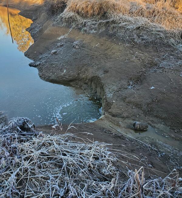
Drainage channel along HWY 126
Drainage channel along HWY 126, near Coyote Creek, OR, where low water levels have exposed a headcut/headward erosion/knickpoint in the sediment.
Drainage channel along HWY 126, near Coyote Creek, OR, where low water levels have exposed a headcut/headward erosion/knickpoint in the sediment.
The USGS, in cooperation with the U.S. Army Corps of Engineers (USACE), is conducting targeted research to better understand geomorphic conditions and processes within the reservoir at Fern Ridge Lake, near Eugene, Oregon, so that managers have the information to support dam operations and other actions that will aid in the preservation and management of cultural sites.
Background:
Media
Sources/Usage: Public Domain. View Media Details
Construction and operation of large reservoirs in the Willamette Valley can affect important cultural, biological, and other natural or economic resources. Fern Ridge Dam, in the Willamette Valley west of Eugene, Oregon, was constructed by the USACE in 1941. Fern Ridge Dam transformed the Long Tom River and surrounding landscape from a broad valley with wetlands and small streams into a shallow reservoir (called Fern Ridge Lake) that is shaped by complex patterns of sediment erosion, deposition, and transport. Fern Ridge Dam was the first of 13 multi-purpose dams in the Willamette Valley that were built to reduce flood risks to downstream communities and provide other benefits such as stored water for irrigation and reservoir-based recreation. Dam operators manage reservoir levels to meet these purposes, and as a result reservoir levels can fluctuate annually by more than 20 feet exposing about 7,400 acres of reservoir bed between minimum and maximum pool levels.
As the reservoir levels rise and fall throughout the year, the areas where sediment builds-up or erodes changes. These changes are influenced by the seasonal flow of streams in the watershed and the amount of sediment they carry into the reservoir, as well as how the reservoir levels are operated.
Why this matters:
Support information for management and preservation of cultural resource sites: The Willamette Valley and the areas within and around the Fern Ridge Lake encompass a landscape that has been used by pre-contact peoples to early historical settlers. As a result, there are widespread and numerous cultural resource sites and archaeological artifacts within and around Fern Ridge Lake which are subject to dynamic erosion and deposition processes influenced by reservoir management.
Support other reservoirs and dam purposes: Results of this study can be used to inform flood-risk management, habitat and wildlife needs, recreation, and infrastructure to ensure the long-term sustainability for ecologically and economically important reservoirs in the Willamette Valley.
Support USGS mission: This effort also supports the USGS core mission of providing reliable data and scientific information to support management of the Nation’s water resources.
Primary objectives:
1) Evaluate geomorphic processes within Fern Ridge Lake and its tributaries with a specific focus on understanding areas, magnitudes, and future trajectories of erosion and deposition to inform cultural resource management questions.
2) Develop a geomorphic framework of landforms and geomorphic processes at Fern Ridge Lake that reflects local geology, pre-dam geomorphology, erosion and deposition, streamflow, flood risk management operations, and other controls.
Images taken during field work.
Fern Ridge Reservoir during low water level
USGS Hydrologist is looking at a headcut/headward erosion/knickpoint in thr center-right of photo during field effort to verify geomorphic mapping.
USGS Hydrologist is looking at a headcut/headward erosion/knickpoint in thr center-right of photo during field effort to verify geomorphic mapping.
Long Tom River
When Fern Ridge Lake levels are low the Long Tom River can be seen meandering through the reservoir. Check out the USGS water elevation gage at Fern Ridge Lake Near Elmira, OR - 14168000.
When Fern Ridge Lake levels are low the Long Tom River can be seen meandering through the reservoir. Check out the USGS water elevation gage at Fern Ridge Lake Near Elmira, OR - 14168000.
Drainage channel along HWY 126
Drainage channel along HWY 126, near Coyote Creek, OR, where low water levels have exposed a headcut/headward erosion/knickpoint in the sediment.
Drainage channel along HWY 126, near Coyote Creek, OR, where low water levels have exposed a headcut/headward erosion/knickpoint in the sediment.