Mackenzie Keith is a Hydrologist at the USGS Oregon Water Science Center.
Mackenzie joined the Oregon Water Science Center in 2009 as a hydrologist on the Geomorphology Team. Her main research focuses on documenting and understanding recent and historical physical changes to rivers to inform restoration and management decisions. Current projects include characterizing the geomorphic responses of dam removal on the Sandy River, mapping the Willamette River floodplain geomorphology, characterizing the coupled upstream-downstream geomorphic responses to deep reservoir drawdowns at Fall Creek Lake, and developing a geomorphic framework to inform erosion and deposition processes within Willamette Valley reservoirs.
Education and Certifications
B.S. in Geology, Oregon State University, 2006
M.S. in Geology, Portland State University, 2012
Science and Products
Below are publications that Mackenzie Keith has authored.
Historical changes to channel planform and bed elevations downstream from dams along Fall Creek and Middle Fork Willamette River, Oregon, 1926–2016
Coupled upstream-downstream geomorphic responses to deep reservoir drawdowns at Fall Creek Dam, Oregon
Monitoring framework to evaluate effectiveness of aquatic and floodplain habitat restoration activities for native fish along the Willamette River, northwestern Oregon
Historical changes in bed elevation and water depth within the Nehalem Bay, Oregon, 1891–2019
Improving flood-frequency analysis with a 4,000-year record of flooding on the Tennessee River near Chattanooga, Tennessee
River network and reach‐scale controls on habitat for lamprey larvae in the Umpqua River Basin, Oregon
Linking sedimentation and erosion patterns with reservoir morphology and dam operations during streambed drawdowns in a flood-control reservoir in the Oregon Cascades
Monitoring framework for evaluating hydrogeomorphic and vegetation responses to environmental flows in the Middle Fork Willamette, McKenzie, and Santiam River Basins, Oregon
GIS database and discussion for the distribution, composition, and age of Cenozoic volcanic rocks of the Pacific Northwest Volcanic Aquifer System study area
Geothermal implications of a refined composition-age geologic map for the volcanic terrains of southeast Oregon, northeast California, and southwest Idaho, USA
Geomorphic response of the North Fork Stillaguamish River to the State Route 530 landslide near Oso, Washington
Summary of environmental flow monitoring for the Sustainable Rivers Project on the Middle Fork Willamette and McKenzie Rivers, western Oregon, 2014–15
Non-USGS Publications**
**Disclaimer: The views expressed in Non-USGS publications are those of the author and do not represent the views of the USGS, Department of the Interior, or the U.S. Government.
Willamette FIP Effectiveness Monitoring Framework
Geomorphic Response to Fall Creek Lake Drawdowns
Marmot Dam Removal
Below are data sets that Mackenzie Keith has authored.
Geomorphic Mapping for the lower Middle Fork Willamette River, Oregon in 2018 and 2020
Surficial and subsurface grain-size data for the Siletz River, Oregon, 2017-18
Active channel mapping for the Siletz River, Oregon, 1939 to 2016
Water temperature data to support effectiveness monitoring of channel and floodplain restoration projects along the Willamette River, Oregon
Geomorphic Mapping of Fall Creek Lake, Oregon, 2016
Geomorphic and larval lamprey surveys in tributaries of the Umpqua River, Oregon
Structure-from-motion datasets of Fall Creek Lake, Oregon, acquired during annual drawdown to streambed November 2016
Fall Creek and Middle Fork Willamette Geomorphic Mapping Geodatabase
Surficial Particle Count and Clay Horizon Marker Data for Fall Creek and the Middle Fork Willamette River, Oregon in 2015-2017
Science and Products
- Publications
Below are publications that Mackenzie Keith has authored.
Filter Total Items: 29Historical changes to channel planform and bed elevations downstream from dams along Fall Creek and Middle Fork Willamette River, Oregon, 1926–2016
Operation of large, multipurpose dams within the Middle Fork Willamette River Basin, Oregon, including the Fall Creek sub-basin, have disrupted natural streamflow and sediment transport regimes and fish passage along the river corridors. Documenting channel morphology, including channel planform, landforms, vegetation cover, and river channel elevations at multiple points in time spanning the 20thAuthorsMackenzie K. Keith, J. Rose Wallick, Gabriel W. Gordon, Heather D. BervidCoupled upstream-downstream geomorphic responses to deep reservoir drawdowns at Fall Creek Dam, Oregon
No abstract available.AuthorsMackenzie K. Keith, J. Rose Wallick, Laurel E. Stratton Garvin, Gabriel W. GordonMonitoring framework to evaluate effectiveness of aquatic and floodplain habitat restoration activities for native fish along the Willamette River, northwestern Oregon
Since 2008, large-scale restoration programs have been implemented along the Willamette River, Oregon, to address historical losses of floodplain habitats caused by dam construction, bank protection, large wood removal, land conversion, and other anthropogenic influences. The Willamette Focused Investment Partnership (WFIP) restoration initiative brings together more than 16 organizations to improAuthorsMackenzie K. Keith, J. Rose Wallick, Rebecca L. Flitcroft, Tobias J. Kock, Laura A. Brown, Rich Miller, Joan C. Hagar, Kathleen Guillozet, Krista L. JonesHistorical changes in bed elevation and water depth within the Nehalem Bay, Oregon, 1891–2019
Estuaries, at the nexus of rivers and the ocean, are depositional areas that respond to changes in streamflow, tides, sea level, and inputs of sediment from marine and watershed sources. Understanding changes in bed elevations, deposited and eroded sediment, and water depth throughout estuaries is relevant for understanding their present-day status and long-term evolution, identifying potential haAuthorsMackenzie K. Keith, Krista L. Jones, Gabriel W. GordonImproving flood-frequency analysis with a 4,000-year record of flooding on the Tennessee River near Chattanooga, Tennessee
This comprehensive field study applied paleoflood hydrology methods to estimate the frequency of low-probability floods for the Tennessee River near Chattanooga, Tennessee. The study combined stratigraphic records of large, previously unrecorded floods with modern streamflow records and historical flood accounts. The overall approach was to (1) develop a flood chronology for the Tennessee River neAuthorsTessa M. Harden, Jim E. O'Connor, Meredith L. Carr, Mackenzie KeithRiver network and reach‐scale controls on habitat for lamprey larvae in the Umpqua River Basin, Oregon
This study developed a spatially explicit framework to support the conservation of Western Brook Lamprey Lampetra richardsoni and Pacific Lamprey Entosphenus tridentatus in the Umpqua River basin, Oregon. This framework identified locations within the river network likely to support “potential burrowing habitat” for lamprey larvae based on geomorphic conditions and evaluated the overlap of potentiAuthorsKrista Jones, Jason B. Dunham, Jim E. O'Connor, Mackenzie K. Keith, Joseph F. Mangano, Kelly Coates, Travis MackieLinking sedimentation and erosion patterns with reservoir morphology and dam operations during streambed drawdowns in a flood-control reservoir in the Oregon Cascades
Since water-year (WY) 2011, pool levels at Fall Creek Lake, Oregon, are temporarily lowered to an elevation near historical streambed each fall, creating free-flowing channel conditions that facilitate downstream passage of juvenile spring Chinook salmon. These drawdown operations have also mobilized substantial quantities of predominantly fine (<2 mm) reservoir sediment as well as some coarser grAuthorsMackenzie K. Keith, Laurel E. StrattonMonitoring framework for evaluating hydrogeomorphic and vegetation responses to environmental flows in the Middle Fork Willamette, McKenzie, and Santiam River Basins, Oregon
This report summarizes a framework for monitoring hydrogeomorphic and vegetation responses to environmental flows in support of the Willamette Sustainable Rivers Program (SRP). The SRP is a partnership between The Nature Conservancy (TNC) and U.S. Army Corps of Engineers (USACE) to provide ecologically sustainable flows downstream of dams while still meeting human needs and congressionally authoriAuthorsJ. Rose Wallick, Leslie B. Bach, Mackenzie K. Keith, Melissa Olson, Joseph F. Mangano, Krista L. JonesGIS database and discussion for the distribution, composition, and age of Cenozoic volcanic rocks of the Pacific Northwest Volcanic Aquifer System study area
A substantial part of the U.S. Pacific Northwest is underlain by Cenozoic volcanic and continental sedimentary rocks and, where widespread, these strata form important aquifers. The legacy geologic mapping presented with this report contains new thematic categorization added to state digital compilations published by the U.S. Geological Survey for Oregon, California, Idaho, Nevada, Utah, and WashiAuthorsDavid R. Sherrod, Mackenzie K. KeithGeothermal implications of a refined composition-age geologic map for the volcanic terrains of southeast Oregon, northeast California, and southwest Idaho, USA
Sufficient temperatures to generate steam likely exist under most of the dominantly volcanic terrains of southeast Oregon, northeast California, and southeast Idaho, USA, but finding sufficient permeability to allow efficient advective heat exchange is an outstanding challenge. A new thematic interpretation of existing state-level geologic maps provides an updated and refined distribution of the cAuthorsErick Burns, Marshall W. Gannett, David R. Sherrod, Mackenzie K. Keith, Jennifer A. Curtis, James R. Bartolino, John A. Engott, Benjamin P. Scandella, Michelle A. Stern, Alan L. FlintGeomorphic response of the North Fork Stillaguamish River to the State Route 530 landslide near Oso, Washington
On March 22, 2014, the State Route 530 Landslide near Oso, Washington mobilized 8 million cubic meters of unconsolidated Pleistocene material, creating a valley‑spanning deposit that fully impounded the North Fork Stillaguamish River. The river overtopped the 8-meter high debris impoundment within 25 hours and began steadily incising a new channel through the center of the deposit. Repeat topograpAuthorsScott W. Anderson, Mackenzie K. Keith, Christopher S. Magirl, J. Rose Wallick, Mark C. Mastin, James R. ForemanSummary of environmental flow monitoring for the Sustainable Rivers Project on the Middle Fork Willamette and McKenzie Rivers, western Oregon, 2014–15
This report presents the results of an ongoing environmental flow monitoring study by The Nature Conservancy (TNC), U.S. Army Corps of Engineers (USACE), and U.S. Geological Survey in support of the Sustainable Rivers Project (SRP) of TNC and USACE. The overarching goal of this study is to evaluate and characterize relations between streamflow, geomorphic processes, and black cottonwood (Populus tAuthorsKrista L. Jones, Joseph F. Mangano, J. Rose Wallick, Heather D. Bervid, Melissa Olson, Mackenzie K. Keith, Leslie BachNon-USGS Publications**
Podolak, C.J., Major, J.J., Keith, M.K., O’Connor, J.E., and Wallick, J.R., 2010, One River’s Response to large dam removal, in Vignettes- on-line case study supplements to Bierman, Paul and Montgomery, David, (eds.), Key Concepts in Geomorphology: W.H. Freemen, Vermont, on-line supplement available at http://serc.carleton.edu/39733.Podolak, C.J., Major, J.J., Keith, M.K., O’Connor, J.E., and Wallick, J.R., 2010, (Sediment) Accounting 101: An Example, in Vignettes- on-line case study supplements to Bierman, Paul and Montgomery, David, (eds.), Key Concepts in Geomorphology: W.H. Freemen, Vermont, on-line supplement available at http://serc.carleton.edu/39732.**Disclaimer: The views expressed in Non-USGS publications are those of the author and do not represent the views of the USGS, Department of the Interior, or the U.S. Government.
- Science
Willamette FIP Effectiveness Monitoring Framework
The goal of this project is to develop an effectiveness monitoring framework that can be used to inform monitoring and data collection for the Willamette River Focused Investment Partnership (WFIP) Effectiveness Monitoring Program. The USGS is developing this monitoring framework in collaboration with the Benton Soil and Water Conservation District (BSWCD), Bonneville Environmental Foundation (BEF...Geomorphic Response to Fall Creek Lake Drawdowns
The USGS has been documenting the geomorphic response to the annual Fall Creek Lake drawdown since 2011.Marmot Dam Removal
Marmot Dam on the Sandy River was removed in 2007 as part of decommissioning of Portland General Electric’s Bull Run Hydroelectric Project. Removal of the 15-meter-tall dam would allow the Sandy River to flow freely for the first time in nearly 100 years and make upstream habitat more accessible to anadromous fish.
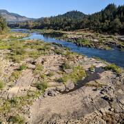
 - Data
Below are data sets that Mackenzie Keith has authored.
Geomorphic Mapping for the lower Middle Fork Willamette River, Oregon in 2018 and 2020
Since 2008, large-scale restoration programs have been implemented along the Willamette River, Oregon, to address historical losses of floodplain habitats for native fish. For much of the Willamette River floodplain, direct enhancement of floodplain habitats through restoration activities is needed because the underlying hydrologic, geomorphic, and vegetation processes that historically created anSurficial and subsurface grain-size data for the Siletz River, Oregon, 2017-18
The Siletz River Basin encompasses 970 square kilometers of western Oregon and drains to the Pacific Ocean. In cooperation with the Confederated Tribes of the Siletz Indians of Oregon (CTSI), the U.S. Geological Survey is evaluating how streamflow and bedload sediment conditions may influence mainstem spawning habitats for spring Chinook Salmon (Oncorhynchus tshawytschya) and Pacific Lamprey (EntoActive channel mapping for the Siletz River, Oregon, 1939 to 2016
The Siletz River Basin encompasses 970 square kilometers of western Oregon and drains to the Pacific Ocean. In cooperation with the Confederated Tribes of the Siletz Indians of Oregon (CTSI), the U.S. Geological Survey is evaluating how streamflow and bedload sediment conditions may influence mainstem spawning habitats for spring Chinook Salmon (Oncorhynchus tshawytschya) and Pacific Lamprey (EntoWater temperature data to support effectiveness monitoring of channel and floodplain restoration projects along the Willamette River, Oregon
Continuous water-temperature data were collected at multiple sites along the Middle Fork and mainstem Willamette Rivers between Jasper and Newberg, Oregon, to support effectiveness monitoring for a large-scale channel and floodplain restoration program (Willamette Focused Investment Partnership, WFIP). Continuous water temperature loggers were deployed at a subset of WFIP restoration sites where rGeomorphic Mapping of Fall Creek Lake, Oregon, 2016
The Middle Fork Willamette River Basin encompasses 3,548 square kilometers of western Oregon and drains to the mainstem Willamette River. Fall Creek Basin encompasses 653 square kilometers and drains to the Middle Fork Willamette River. In cooperation with the U.S. Army Corps of Engineers, the U.S. Geological Survey evaluated geomorphic responses to dam operations at Fall Creek Lake in which lakeGeomorphic and larval lamprey surveys in tributaries of the Umpqua River, Oregon
Interactions between geomorphic processes at multiple scales shape the distributions of habitats, species, and life stages that a river can support. Understanding these hierarchical processes may be helpful for proactive monitoring and restoration of native Western Brook Lamprey (Lampetra richardsoni) and Pacific Lamprey (Entosphenus tridentatus) in Pacific Northwest rivers. The processes creatingStructure-from-motion datasets of Fall Creek Lake, Oregon, acquired during annual drawdown to streambed November 2016
The Middle Fork Willamette River basin encompasses 3,548 square kilometers of western Oregon and drains to the mainstem Willamette River. Fall Creek basin encompasses 653 square kilometers and drains to the Middle Fork Willamette River. In cooperation with the U.S. Army Corps of Engineers, the U.S. Geological Survey evaluated geomorphic responses of downstream river corridors to annual drawdowns tFall Creek and Middle Fork Willamette Geomorphic Mapping Geodatabase
The Middle Fork Willamette River Basin encompasses 3,548 square kilometers of western Oregon and drains to the mainstem Willamette River. Fall Creek Basin encompasses 653 square kilometers and drains to the Middle Fork Willamette River. In cooperation with the U.S. Army Corps of Engineers, the U.S. Geological Survey evaluated geomorphic responses of downstream river corridors to annual drawdowns tSurficial Particle Count and Clay Horizon Marker Data for Fall Creek and the Middle Fork Willamette River, Oregon in 2015-2017
The Middle Fork Willamette River Basin encompasses 3,548 square kilometers of western Oregon and drains to the mainstem Willamette River. Fall Creek Basin encompasses 653 square kilometers and drains to the Middle Fork Willamette River. In cooperation with the U.S. Army Corps of Engineers, the U.S. Geological Survey evaluated geomorphic responses of downstream river corridors to annual drawdowns t - Multimedia
- News