
Epic September 2009 Flooding - Georgia
Many days of continuous heavy rain in mid-September 2009 resulted in flooding in many parts of Georgia, especially in north Georgia and the Atlanta region. The rains produced streamflows of record proportions. rivers and streams had magnitudes so great that the odds of it happening were less than 0.2 percent in any given year. In other words, there was less than a 1 in 500 chance that parts of Cobb and Douglas counties were going to be hit with such an event.
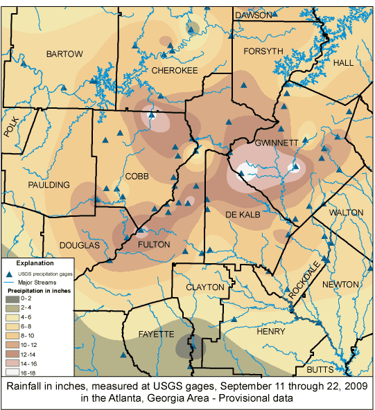
In Georgia the USGS maintains a network of more than 300 stream gages that provide data in real time. Data from these gages are used by local, state and federal officials for numerous purposes, including public safety and flood forecasting by the National Weather Service. USGS crews repaired 20 gages after the 2009 historic flooding.
In the Atlanta area:
- The Yellow River streamgages in Gwinnett, DeKalb and Rockdale counties measured flows between the 1 percent chance (100-year) and 0.5 percent chance (200-year) flood magnitude.
- Flows caused by the rain at Peachtree Creek in Atlanta were only near the 10 percent chance (10-year) flood magnitude, but the backwater effects from the Chattahoochee River pushed water levels over the 0.2 percent chance (500-year) flood at the gage location.
- On the Chattahoochee, USGS measured a 1 percent chance exceedence (100-year) flood at Vinings and Roswell.
| USGS Site ID | Site Name | Peak Streamflow (cubic feet per second) | Peak Gage Height (feet) | Date of Peak |
|---|---|---|---|---|
| 2204070 | SOUTH RIVER AT KLONDIKE ROAD, NEAR LITHONIA, GA | 13,800 | 13.55 | 9/21/2009 |
| 2204130 | HONEY CREEK AT GA 212, NEAR CONYERS, GA | 2,730 | 9.52 | 9/22/2009 |
| 2205522 | PEW CREEK AT PATTERSON RD, NEAR LAWRENCEVILLE, GA | -- | 15 | 9/21/2009 |
| 2207120 | YELLOW RIVER AT GA 124, NEAR LITHONIA, GA | 17,100 | 27.47 | 9/21/2009 |
| 2337185 | NO BUSINESS CREEK AT LEE ROAD, BELOW SNELLVILLE, GA | -- | 8.83 | 9/21/2009 |
| 2207220 | YELLOW RIVER AT PLEASANT HILL ROAD, NR LITHONIA,GA | 21,000 | 25.54 | 9/22/2009 |
| 2207335 | YELLOW RIVER AT GEES MILL ROAD, NEAR MILSTEAD, GA | 19,400 | 22.53 | 9/22/2009 |
| 2208050 | ALCOVY RIVER NEAR LAWRENCEVILLE, GA | -- | 8.28 | 9/21/2009 |
| 2208130 | SHOAL CREEK AT PAPER MILL RD, NR LAWRENCEVILLE, GA | 771 | 13.12 | 9/21/2009 |
| 2208150 | ALCOVY RIVER AT NEW HOPE ROAD, NEAR GRAYSON, GA | 6,510 | 13.87 | 9/21/2009 |
| 2218565 | APALACHEE RIVER AT FENCE ROAD, NEAR DACULA, GA | -- | 8.56 | 9/21/2009 |
| 2334480 | RICHLAND CREEK AT SUWANEE DAM ROAD, NEAR BUFORD,GA | 1,610 | 7.27 | 9/21/2009 |
| 2334578 | LEVEL CREEK AT SUWANEE DAM ROAD, NEAR SUWANEE, GA | 1,830 | 11.6 | 9/21/2009 |
| 2334620 | DICK CREEK AT OLD ATLANTA RD, NEAR SUWANEE, GA | 1,480 | 11.72 | 9/21/2009 |
| 2334885 | SUWANEE CREEK AT SUWANEE, GA | 7870 | 14.3 | 9/21/2009 |
| 2335000 | CHATTAHOOCHEE RIVER NEAR NORCROSS, GA | 14,900 | 14.51 | 9/21/2009 |
| 2335350 | CROOKED CREEK NEAR NORCROSS, GA | -- | 14.59 | 9/22/2009 |
| 2335450 | CHATTAHOOCHEE RIVER ABOVE ROSWELL, GA | 21,100 | 11.96 | 9/21/2009 |
| 2335757 | BIG CREEK BELOW HOG WALLOW CREEK AT ROSWELL, GA | 6,370 | 15.41 | 9/22/2009 |
| 2335815 | CHATTAHOOCHEE RIVER BELOW MORGAN FALLS DAM, GA | 30,900 | 826.96 | 9/21/2009 |
| 2335870 | SOPE CREEK NEAR MARIETTA, GA | 9,400 | 18.29 | 9/21/2009 |
| 2335910 | ROTTENWOOD CR AT INTERSTATE N PKWY, NR SMYRNA, GA | 4,840 | 11.74 | 9/21/2009 |
| 2336000 | CHATTAHOOCHEE RIVER AT ATLANTA, GA | 40,900 | 28.12 | 9/22/2009 |
| 2336030 | N.F. PEACHTREE CREEK AT GRAVES RD, NR DORAVILLE,GA | 3,590 | 12.93 | 9/21/2009 |
| 2336120 | N.F. PEACHTREE CREEK, BUFORD HWY, NEAR ATLANTA, GA | 6,140 | 18.57 | 9/21/2009 |
| 2336300 | PEACHTREE CREEK AT ATLANTA, GA | 9,050 | 22.91 | 9/21/2009 |
| 2336360 | NANCY CREEK AT RICKENBACKER DRIVE, AT ATLANTA, GA | -- | 14.69 | 9/21/2009 |
| 2336490 | CHATTAHOOCHEE RIVER AT GA 280 | 42,300 | 35.98 | 9/22/2009 |
| 2336526 | PROCTOR CREEK AT JACKSON PARKWAY, AT ATLANTA, GA | 6,240 | 14.93 | 9/22/2009 |
| 2336635 | NICKAJACK CREEK AT US 78/278, NEAR MABLETON, GA | 5,090 | 19.85 | 9/21/2009 |
| 2336728 | UTOY CREEK AT GREAT SOUTHWEST PARKWAY | -- | 27.89 | 9/22/2009 |
| 2396870 | POWDER SPRINGS CREEK NEAR POWDER SPRINGS, GA | 8,420 | 19.82 | 9/21/2009 |
| 2336968 | NOSES CREEK AT POWDER SPRINGS RD, POWDER SPRINGS, GA | -- | 23.2 | 9/22/2009 |
| 2336986 | OLLEY CREEK AT CLAY ROAD, NEAR AUSTELL, GA | -- | 27.4 | 9/22/2009 |
| 2337000 | SWEETWATER CREEK NEAR AUSTELL, GA | 31500 | 30.8 | 9/22/2009 |
| 2337170 | CHATTAHOOCHEE RIVER NEAR FAIRBURN, GA | 63,900 | 30.65 | 9/22/2009 |
| 2337410 | DOG RIVER AT GA 5, NEAR FAIRPLAY, GA | 59900 | 33.8 | 9/21/2009 |
| 2337500 | SNAKE CREEK NEAR WHITESBURG, GA | 10,900 | 17.3 | 9/21/2009 |
| 2338000 | CHATTAHOOCHEE RIVER NEAR WHITESBURG, GA | 60,900 | 29.84 | 9/23/2009 |
| 2392780 | LITTLE RIVER AT GA 5, NEAR WOODSTOCK, GA | 16,100 | 20.8 | 9/21/2009 |
| 2392950 | NOONDAY CREEK AT HAWKINS STORE RD, NR WOODSTOCK,GA | 12,200 | 17.2 | 9/21/2009 |
| 2392975 | NOONDAY CREEK AT SHALLOWFORD ROAD, NR WOODSTOCK,GA | 11,300 | 19.66 | 9/21/2009 |
| 2393377 | BUTLER CREEK AT MACK DOBBS ROAD, NR KENNESAW, GA | 6,760 | 14.27 | 9/21/2009 |
| 2413000 | LITTLE TALLAPOOSA RIVER AT US 27, AT CARROLLTON,GA | 6,520 | 17.05 | 9/21/2009 |

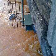
Combined Stormwater/Sewage Overflow, Roswell, GA, Sept. 2009
Epic September 2009 flooding around Atlanta, Georgia. An overflowing sewer on Riverside Road, Roswell, Georgia. Likely this is a storm sewer, designed to carry stormwater runoff off of streets, that cannot handle the volume of runoff.In older sections of Atlanta there are combined sewer systems that are sewers that are designed to collect rainwater runoff, domestic sewage, and industrial...

Normal flow conditions at Big (Vickery) Creek, Chattahoochee National Recreation Area, Roswell, Fulton County, Georgia.
Normal flow conditions at Big (Vickery) Creek, Chattahoochee National Recreation Area, Roswell, Fulton County, Georgia.
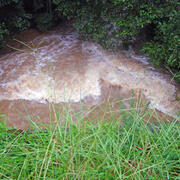
Flood conditions, Sept. 21st, 2009, at Big (Vickery) Creek, Chattahoochee National Recreation Area, Roswell, Fulton County, Georgia.
Flood conditions, Sept. 21st, 2009, at Big (Vickery) Creek, Chattahoochee National Recreation Area, Roswell, Fulton County, Georgia.

Water being released from the Morgan Falls Dam, Chattahoochee River, City of Sandy Springs, Fulton and Cobb Counties, Georgia.
Water being released from the Morgan Falls Dam, Chattahoochee River, City of Sandy Springs, Fulton and Cobb Counties, Georgia.

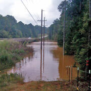
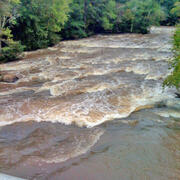
September 2009 Flooding Chattahoochee River near Whitesburg (02338000)
Epic September 2009 FloodingChattahoochee River near Whitesburg (02338000)
September 2009 Flooding Powder Springs Creek near Powder Springs (02336870)
September 2009 Flooding Powder Springs Creek near Powder Springs (02336870)

September 2009 Flooding Allatoona Creek near Acworth (02393419)
September 2009 Flooding Allatoona Creek near Acworth (02393419)

September 2009 Flooding Sweetwater Creek at Interstate 20, Lithia Springs, Georgia
This is the Interstate 20 bridge over Sweetwater Creek. The USGS hydrographer is hand-pulling an Acoustic Doppler Current Profiler across the channel. The instrument, on the small orange catamaran in the picture, determines the depth of the channel and the discharge of the water and transmits data to a laptop in the van in the far left of the photo. The channel was up to 30 feet deep in places and...

Peachtree Creek, Atlanta, Ga. Comparison of low and high flows.
Base flow and flood conditions comparison at Peachtree Creek, Atlanta, Ga. The pictures below compares normal base-flow conditions (river stage at about 3 feet) on the left with the flooding in Sept. 2009 (river stage about 20 feet). Peachtree Creek is an urban site and the large amount of impervious surfaces in the watershed can influece flooding characteristics.
September 2009 Flooding Nancy Creek at West Wesley Rd., Atlanta (02336410)
September 2009 Flooding Nancy Creek at West Wesley Rd., Atlanta (02336410)
September 2009 Flooding Chattahoochee River at Fairburn (02337170)
September 2009 Flooding Chattahoochee River at Fairburn (02337170)
September 2009 Flooding Wheeler Creek at Bill Cheek Rd, near Auburn (02217274)
September 2009 Flooding Wheeler Creek at Bill Cheek Rd, near Auburn (02217274)
September 2009 Flooding Yellow River near Stewart (02208005)
September 2009 Flooding Yellow River near Stewart (02208005)
September 2009 Flooding Alcovy River near Stewart (02209260)
September 2009 Flooding Alcovy River near Stewart (02209260)
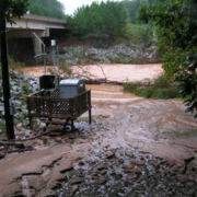
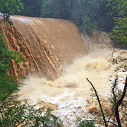
USGS station 02337410 Dog River at Ga 5, near Fairplay, Ga, photo taken during the 2009 flood event, this station recorded a peak gage height of 33.83 feet with a corresponding peak streamflow of 59,900 cubic feet per second.
USGS station 02337410 Dog River at Ga 5, near Fairplay, Ga, photo taken during the 2009 flood event, this site recorded a peak gage height of 33.83 feet with a corresponding peak streamflow of 59,900 cubic feet per second.
Many days of continuous heavy rain in mid-September 2009 resulted in flooding in many parts of Georgia, especially in north Georgia and the Atlanta region. The rains produced streamflows of record proportions. rivers and streams had magnitudes so great that the odds of it happening were less than 0.2 percent in any given year. In other words, there was less than a 1 in 500 chance that parts of Cobb and Douglas counties were going to be hit with such an event.
In Georgia the USGS maintains a network of more than 300 stream gages that provide data in real time. Data from these gages are used by local, state and federal officials for numerous purposes, including public safety and flood forecasting by the National Weather Service. USGS crews repaired 20 gages after the 2009 historic flooding.
In the Atlanta area:
- The Yellow River streamgages in Gwinnett, DeKalb and Rockdale counties measured flows between the 1 percent chance (100-year) and 0.5 percent chance (200-year) flood magnitude.
- Flows caused by the rain at Peachtree Creek in Atlanta were only near the 10 percent chance (10-year) flood magnitude, but the backwater effects from the Chattahoochee River pushed water levels over the 0.2 percent chance (500-year) flood at the gage location.
- On the Chattahoochee, USGS measured a 1 percent chance exceedence (100-year) flood at Vinings and Roswell.
| USGS Site ID | Site Name | Peak Streamflow (cubic feet per second) | Peak Gage Height (feet) | Date of Peak |
|---|---|---|---|---|
| 2204070 | SOUTH RIVER AT KLONDIKE ROAD, NEAR LITHONIA, GA | 13,800 | 13.55 | 9/21/2009 |
| 2204130 | HONEY CREEK AT GA 212, NEAR CONYERS, GA | 2,730 | 9.52 | 9/22/2009 |
| 2205522 | PEW CREEK AT PATTERSON RD, NEAR LAWRENCEVILLE, GA | -- | 15 | 9/21/2009 |
| 2207120 | YELLOW RIVER AT GA 124, NEAR LITHONIA, GA | 17,100 | 27.47 | 9/21/2009 |
| 2337185 | NO BUSINESS CREEK AT LEE ROAD, BELOW SNELLVILLE, GA | -- | 8.83 | 9/21/2009 |
| 2207220 | YELLOW RIVER AT PLEASANT HILL ROAD, NR LITHONIA,GA | 21,000 | 25.54 | 9/22/2009 |
| 2207335 | YELLOW RIVER AT GEES MILL ROAD, NEAR MILSTEAD, GA | 19,400 | 22.53 | 9/22/2009 |
| 2208050 | ALCOVY RIVER NEAR LAWRENCEVILLE, GA | -- | 8.28 | 9/21/2009 |
| 2208130 | SHOAL CREEK AT PAPER MILL RD, NR LAWRENCEVILLE, GA | 771 | 13.12 | 9/21/2009 |
| 2208150 | ALCOVY RIVER AT NEW HOPE ROAD, NEAR GRAYSON, GA | 6,510 | 13.87 | 9/21/2009 |
| 2204070 | SOUTH RIVER AT KLONDIKE ROAD, NEAR LITHONIA, GA | 13,800 | 13.55 | 9/21/2009 |
| 2204130 | HONEY CREEK AT GA 212, NEAR CONYERS, GA | 2,730 | 9.52 | 9/22/2009 |
| 2205522 | PEW CREEK AT PATTERSON RD, NEAR LAWRENCEVILLE, GA | -- | 15 | 9/21/2009 |
| 2207120 | YELLOW RIVER AT GA 124, NEAR LITHONIA, GA | 17,100 | 27.47 | 9/21/2009 |
| 2337185 | NO BUSINESS CREEK AT LEE ROAD, BELOW SNELLVILLE, GA | -- | 8.83 | 9/21/2009 |
| 2207220 | YELLOW RIVER AT PLEASANT HILL ROAD, NR LITHONIA,GA | 21,000 | 25.54 | 9/22/2009 |
| 2207335 | YELLOW RIVER AT GEES MILL ROAD, NEAR MILSTEAD, GA | 19,400 | 22.53 | 9/22/2009 |
| 2208050 | ALCOVY RIVER NEAR LAWRENCEVILLE, GA | -- | 8.28 | 9/21/2009 |
| 2208130 | SHOAL CREEK AT PAPER MILL RD, NR LAWRENCEVILLE, GA | 771 | 13.12 | 9/21/2009 |
| 2208150 | ALCOVY RIVER AT NEW HOPE ROAD, NEAR GRAYSON, GA | 6,510 | 13.87 | 9/21/2009 |
| 2218565 | APALACHEE RIVER AT FENCE ROAD, NEAR DACULA, GA | -- | 8.56 | 9/21/2009 |
| 2334480 | RICHLAND CREEK AT SUWANEE DAM ROAD, NEAR BUFORD,GA | 1,610 | 7.27 | 9/21/2009 |
| 2334578 | LEVEL CREEK AT SUWANEE DAM ROAD, NEAR SUWANEE, GA | 1,830 | 11.6 | 9/21/2009 |
| 2334620 | DICK CREEK AT OLD ATLANTA RD, NEAR SUWANEE, GA | 1,480 | 11.72 | 9/21/2009 |
| 2334885 | SUWANEE CREEK AT SUWANEE, GA | 7870 | 14.3 | 9/21/2009 |
| 2335000 | CHATTAHOOCHEE RIVER NEAR NORCROSS, GA | 14,900 | 14.51 | 9/21/2009 |
| 2335350 | CROOKED CREEK NEAR NORCROSS, GA | -- | 14.59 | 9/22/2009 |
| 2335450 | CHATTAHOOCHEE RIVER ABOVE ROSWELL, GA | 21,100 | 11.96 | 9/21/2009 |
| 2335757 | BIG CREEK BELOW HOG WALLOW CREEK AT ROSWELL, GA | 6,370 | 15.41 | 9/22/2009 |
| 2335815 | CHATTAHOOCHEE RIVER BELOW MORGAN FALLS DAM, GA | 30,900 | 826.96 | 9/21/2009 |
| 2335870 | SOPE CREEK NEAR MARIETTA, GA | 9,400 | 18.29 | 9/21/2009 |
| 2335910 | ROTTENWOOD CR AT INTERSTATE N PKWY, NR SMYRNA, GA | 4,840 | 11.74 | 9/21/2009 |
| 2336000 | CHATTAHOOCHEE RIVER AT ATLANTA, GA | 40,900 | 28.12 | 9/22/2009 |
| 2336030 | N.F. PEACHTREE CREEK AT GRAVES RD, NR DORAVILLE,GA | 3,590 | 12.93 | 9/21/2009 |
| 2336120 | N.F. PEACHTREE CREEK, BUFORD HWY, NEAR ATLANTA, GA | 6,140 | 18.57 | 9/21/2009 |
| 2336300 | PEACHTREE CREEK AT ATLANTA, GA | 9,050 | 22.91 | 9/21/2009 |
| 2336360 | NANCY CREEK AT RICKENBACKER DRIVE, AT ATLANTA, GA | -- | 14.69 | 9/21/2009 |
| 2336490 | CHATTAHOOCHEE RIVER AT GA 280 | 42,300 | 35.98 | 9/22/2009 |
| 2336526 | PROCTOR CREEK AT JACKSON PARKWAY, AT ATLANTA, GA | 6,240 | 14.93 | 9/22/2009 |
| 2336635 | NICKAJACK CREEK AT US 78/278, NEAR MABLETON, GA | 5,090 | 19.85 | 9/21/2009 |
| 2336728 | UTOY CREEK AT GREAT SOUTHWEST PARKWAY | -- | 27.89 | 9/22/2009 |
| 2396870 | POWDER SPRINGS CREEK NEAR POWDER SPRINGS, GA | 8,420 | 19.82 | 9/21/2009 |
| 2336968 | NOSES CREEK AT POWDER SPRINGS RD, POWDER SPRINGS, GA | -- | 23.2 | 9/22/2009 |
| 2336986 | OLLEY CREEK AT CLAY ROAD, NEAR AUSTELL, GA | -- | 27.4 | 9/22/2009 |
| 2337000 | SWEETWATER CREEK NEAR AUSTELL, GA | 31500 | 30.8 | 9/22/2009 |
| 2337170 | CHATTAHOOCHEE RIVER NEAR FAIRBURN, GA | 63,900 | 30.65 | 9/22/2009 |
| 2337410 | DOG RIVER AT GA 5, NEAR FAIRPLAY, GA | 59900 | 33.8 | 9/21/2009 |
| 2337500 | SNAKE CREEK NEAR WHITESBURG, GA | 10,900 | 17.3 | 9/21/2009 |
| 2338000 | CHATTAHOOCHEE RIVER NEAR WHITESBURG, GA | 60,900 | 29.84 | 9/23/2009 |
| 2392780 | LITTLE RIVER AT GA 5, NEAR WOODSTOCK, GA | 16,100 | 20.8 | 9/21/2009 |
| 2392950 | NOONDAY CREEK AT HAWKINS STORE RD, NR WOODSTOCK,GA | 12,200 | 17.2 | 9/21/2009 |
| 2392975 | NOONDAY CREEK AT SHALLOWFORD ROAD, NR WOODSTOCK,GA | 11,300 | 19.66 | 9/21/2009 |
| 2393377 | BUTLER CREEK AT MACK DOBBS ROAD, NR KENNESAW, GA | 6,760 | 14.27 | 9/21/2009 |
| 2413000 | LITTLE TALLAPOOSA RIVER AT US 27, AT CARROLLTON,GA | 6,520 | 17.05 | 9/21/2009 |
Combined Stormwater/Sewage Overflow, Roswell, GA, Sept. 2009
Epic September 2009 flooding around Atlanta, Georgia. An overflowing sewer on Riverside Road, Roswell, Georgia. Likely this is a storm sewer, designed to carry stormwater runoff off of streets, that cannot handle the volume of runoff.In older sections of Atlanta there are combined sewer systems that are sewers that are designed to collect rainwater runoff, domestic sewage, and industrial...
Normal flow conditions at Big (Vickery) Creek, Chattahoochee National Recreation Area, Roswell, Fulton County, Georgia.
Normal flow conditions at Big (Vickery) Creek, Chattahoochee National Recreation Area, Roswell, Fulton County, Georgia.
Flood conditions, Sept. 21st, 2009, at Big (Vickery) Creek, Chattahoochee National Recreation Area, Roswell, Fulton County, Georgia.
Flood conditions, Sept. 21st, 2009, at Big (Vickery) Creek, Chattahoochee National Recreation Area, Roswell, Fulton County, Georgia.
Water being released from the Morgan Falls Dam, Chattahoochee River, City of Sandy Springs, Fulton and Cobb Counties, Georgia.
Water being released from the Morgan Falls Dam, Chattahoochee River, City of Sandy Springs, Fulton and Cobb Counties, Georgia.
September 2009 Flooding Chattahoochee River near Whitesburg (02338000)
Epic September 2009 FloodingChattahoochee River near Whitesburg (02338000)
September 2009 Flooding Powder Springs Creek near Powder Springs (02336870)
September 2009 Flooding Powder Springs Creek near Powder Springs (02336870)
September 2009 Flooding Allatoona Creek near Acworth (02393419)
September 2009 Flooding Allatoona Creek near Acworth (02393419)
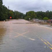
September 2009 Flooding Sweetwater Creek at Interstate 20, Lithia Springs, Georgia
This is the Interstate 20 bridge over Sweetwater Creek. The USGS hydrographer is hand-pulling an Acoustic Doppler Current Profiler across the channel. The instrument, on the small orange catamaran in the picture, determines the depth of the channel and the discharge of the water and transmits data to a laptop in the van in the far left of the photo. The channel was up to 30 feet deep in places and...
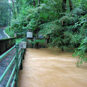
Peachtree Creek, Atlanta, Ga. Comparison of low and high flows.
Base flow and flood conditions comparison at Peachtree Creek, Atlanta, Ga. The pictures below compares normal base-flow conditions (river stage at about 3 feet) on the left with the flooding in Sept. 2009 (river stage about 20 feet). Peachtree Creek is an urban site and the large amount of impervious surfaces in the watershed can influece flooding characteristics.
September 2009 Flooding Nancy Creek at West Wesley Rd., Atlanta (02336410)
September 2009 Flooding Nancy Creek at West Wesley Rd., Atlanta (02336410)
September 2009 Flooding Chattahoochee River at Fairburn (02337170)
September 2009 Flooding Chattahoochee River at Fairburn (02337170)
September 2009 Flooding Wheeler Creek at Bill Cheek Rd, near Auburn (02217274)
September 2009 Flooding Wheeler Creek at Bill Cheek Rd, near Auburn (02217274)
September 2009 Flooding Yellow River near Stewart (02208005)
September 2009 Flooding Yellow River near Stewart (02208005)
September 2009 Flooding Alcovy River near Stewart (02209260)
September 2009 Flooding Alcovy River near Stewart (02209260)
USGS station 02337410 Dog River at Ga 5, near Fairplay, Ga, photo taken during the 2009 flood event, this station recorded a peak gage height of 33.83 feet with a corresponding peak streamflow of 59,900 cubic feet per second.
USGS station 02337410 Dog River at Ga 5, near Fairplay, Ga, photo taken during the 2009 flood event, this site recorded a peak gage height of 33.83 feet with a corresponding peak streamflow of 59,900 cubic feet per second.