
Coastal Flooding and Erosion
Coastal Flooding and Erosion
Filter Total Items: 5

Methodology development and assessment of scour envelope curves for SCDOT bridges in the Charleston coastal environment
The U.S. Geological Survey, in cooperation with the South Carolina Department of Transportation (SCDOT) and Federal Highway Administration (FHWA), has evaluated clear-water and live-bed pier, contraction, and abutment scour associated with over 200 bridges throughout South Carolina for many years, predominantly at non-tidally influenced sites. These evaluations resulted in the development of...

South Atlantic Water Science Center Storm-Tide Monitoring
Preventing flood hazards, such as the hurricane induced storm surge, from becoming human disasters requires an understanding of the relative risks floods pose to specific communities and knowledge of the processes by which flood waters rise, converge, and abate. Historically, hurricane-induced storm tides have been documented through measurement of high-water marks left on structures or vegetation...
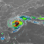
Hurricane Florence 2018
The South Atlantic Water Science Center prepares for Hurricane Florence to make landfall along the Carolina coast.

SAWSC Monitoring of Hydrologic Hazards
A major element of the USGS mission is the documentation of the extent and magnitude of extreme hydrologic events, like floods and droughts. The South Atlantic Water Science Center is a leader in monitoring extreme water conditions, from droughts and falling groundwater levels to floods and storm-tide surges to water-quality problems.

Hurricane Matthew Information Portal
As Hurricane Matthew moved up the Atlantic coast of the U.S., the USGS South Atlantic Water Science Center (SAWSC) deployed most of the USGS Storm-Tide Network along the Atlantic coast to monitor the timing, extent, and magnitude of the storm tide during the passage of Hurricane Matthew.