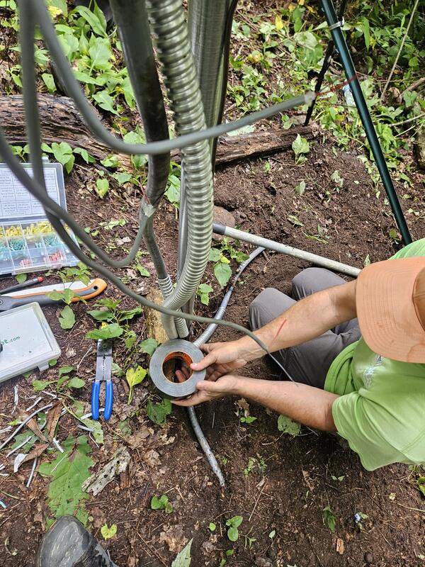
U.S. flag

An official website of the United States government

Multimedia

South Atlantic Water Science Center multimedia.

Images

Image of USGS Real-Time Flood Impact Map web application
USGS Real-Time Flood Impact Map web application

Image of USGS Real-Time Flood Impact Map web application, which give locations with current flooding conditions.

Two maps of Chesapeake Bay watershed and line graph below maps. Left: Predicted median annual SC. Right: SC departure class.
Diagram showing predicted median annual specific conductance (SC) for all modeled stream reaches in the Chesapeake Bay watershed

(a) Predicted median annual specific conductance (SC) for all modeled stream reaches in the Chesapeake Bay watershed (CBW) for the 2014–2016 time period. (b) SC departure classes for the 2014–2016 time period. (c) Percent of the modeled CBW area in each of the departure classes over the four time periods.

USGS National Water Dashboard Map of River Flooding in Georgia and Western Carolinas from Tropical Storm Helene
River Flooding from Tropical Storm Helene

USGS National Water Dashboard Map of River Flooding in Georgia and Western Carolinas from Tropical Storm Helene

USGS National Water Dashboard Map of River Flooding in Georgia and Western Carolinas from Tropical Storm Helene

A man with a lifejacket is standing on a bridge, holding a rope attached to orange science equipment in the river below.
USGS Responds to Tropical Storm Debby in Georgia

Andrew Robinson, a USGS hydrological technician, is making a measurement at Ebenezer Creek at Springfield, GA. This site number is 02198690. (Photo by Andrew Robinson, USGS.)

A man in a green shirt is building a gauge for rapid deployment. The gauge is a large black box, sitting on a workbench.
USGS response to Tropical Storm Debby in Georgia

Drew Robinson, a USGS hydrological technician, is putting a Rapid Deployment Gauge together for the Georgia Department of Transportation on Wednesday, August 7. He built the RDG and deployed it in Statesboro in the early evening. That RDG was used to help the local community experiencing bad floods on Lotts Creek.

Drew Robinson, a USGS hydrological technician, is putting a Rapid Deployment Gauge together for the Georgia Department of Transportation on Wednesday, August 7. He built the RDG and deployed it in Statesboro in the early evening. That RDG was used to help the local community experiencing bad floods on Lotts Creek.

Webcams

Oconaluftee River at Birdtown, NC (03512000)

We have installed a webcam at Oconaluftee River at Birdtown, NC to allow you to view the current conditions.

Latest image of Crooked Creek, Bennettsville, SC
Crooked Creek Below N Marlboro ST at Bennettsville, SC (021305805)

We have installed a webcam at Crooked Creek, N. Marlboro St, Bennettsville to allow you to view the current conditions.

Latest image from Little Hope Creek at Seneca Place, Charlotte, NC
Little Hope Creek at Seneca Place, Charlotte, NC (02146470)

We have installed a webcam at Little Hope Creek at Seneca Place, Charlotte, NC to allow you to view the current conditions.

Latest image of South Buffalo Creek, near Pomona, NC
South Buffalo Creek NR Pomona, Greensboro, NC (02094659)

We have installed a webcam at South Buffalo Creek, Pomona, NC to allow you to view the current conditions.

Latest image at Briar Creek at Providence Road, Charlotte, NC
Briar Creek at Providence Road, Charlotte, NC (02146449)

We have installed a webcam at Briar Creek at Providence Road, Charlotte, NC to allow you to view the current conditions.

Latest image from Briar Creek at Shamrock Drive, Charlotte, NC
Briar Creek at Shamrock Drive, Charlotte, NC (0214642825)

We have installed a webcam at Briar Creek at Shamrock Drive, Charlotte, NC to allow you to view the current conditions.

Was this page helpful?