
Low-Cost Sensor Networks for Pluvial Flash Flood Detection and Early Warning in Urban Areas
Flooding in urban areas is a serious weather-related threat to life and property. One type of flooding, called pluvial flooding, occurs during periods of intense rainfall where runoff overwhelms the capacity of soil to absorb it. In urban areas, pluvial flooding can be particularly dangerous because much of a city is covered by impervious surfaces such as streets, roofs, and parking lots forcing runoff to rapidly enter drainage networks faster than they are designed to carry it away. Unlike floods from rivers or the oceans, which can build up over hours or days, pluvial floods can occur quickly, sometimes in just minutes, leaving little time to react. Pluvial floods are also difficult to predict at the hyperlocal scale needed to better prepare emergency response personnel.
As cities continue to expand and stormwater infrastructure ages, the likelihood of drainage systems becoming overwhelmed continues to increase, leaving urban areas more exposed to damage from extreme storms (Acosta-Coll and others, 2018; Gimeno and others, 2022). The risks may be amplified by long-term climate trends. The U.S Environmental Protection Agency has shown extreme one-day precipitation events in the United States have steadily increased since 1970 (U. S. Environmental Protection Agency, 2025). The seriousness of this trend became clear in 2025, when the National Weather Service issued a record number of flash flood warnings, the highest in nearly four decades (ForecastWatch, 2025).
In 2018, the City of Madison, like many other communities across the U.S., experienced an extreme precipitation event that caused major flood damage. Since 2018, the city has initiated a variety of flood mitigation projects and watershed modeling studies to address widespread deficiencies in their stormwater conveyance system. In 2021, the U.S. Geological Survey began developing a low-cost flash flood detection and early warning network for the City of Madison as part of the Next Generation Water Observing Systems program (NGWOS). The network was intended to provide city engineers advance warning of impending flood conditions at select locations throughout the city to help reduce delay in response.
Selecting Equipment that Meets the Demands of Urban Street Flooding
USGS worked closely with city engineers to identify select areas that were most vulnerable to flooding. Low-cost Internet-of-Things (IoT) devices equipped with submersible pressure transducers were then installed at each location to measure real-time water levels inside storm sewers while remaining safely outside traffic corridors. The IoT devices selected for this study transmit data using a hybrid communication system that combines long-range wide area network (LoRaWAN) radio technology with Message Queuing Telemetry Transport (MQTT) messaging. LoRa is a low-power, long-range wireless communication protocol well suited for sending small packets of data. Its ability to reliably transmit data over long distances while consuming minimal energy makes it an ideal choice for urban flood monitoring where sensors must have a small footprint, long battery life, and remain in place for extended periods.
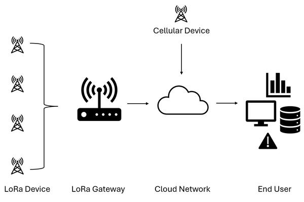
Each LoRa device is programmed to record and transmit water level measurements every five minutes. Data are sent via radio frequency to a nearby LoRa gateway, which acts as a relay point. The gateway then forwards the data to a cloud-based server, where it can be stored, analyzed, and accessed in real time. This approach makes it possible to collect information simultaneously from many sensors deployed across an urban catchment, creating a dense monitoring network (figure 1).
While LoRa technology is well suited for long-distance, low-power data transmission, its effectiveness can be limited by local topography and physical barriers. For example, steep terrain, building density, or underground locations may prevent signals from reliably reaching a gateway. In areas where LoRa coverage was limited or unreliable, cellular-enabled sensors were deployed instead. These devices bypass the gateway entirely by transmitting water level data directly to the cloud server using existing cellular networks (figure 1). By combining LoRa-based sensors with cellular-enabled devices, the monitoring network can provide coverage of vulnerable areas. This hybrid approach allows for flexible deployment across varied urban landscapes.
Overcoming the Challenge of Monitoring Urban Landscapes
Monitoring water levels in storm sewers presents unique challenges that limit the use of traditional gauging equipment. Unlike open streams or rivers, storm sewers are located underground and are often accessible only through manholes situated in the middle of busy streets. Traditional monitoring systems, which typically require more energy and frequent maintenance, are therefore not practical in these settings.
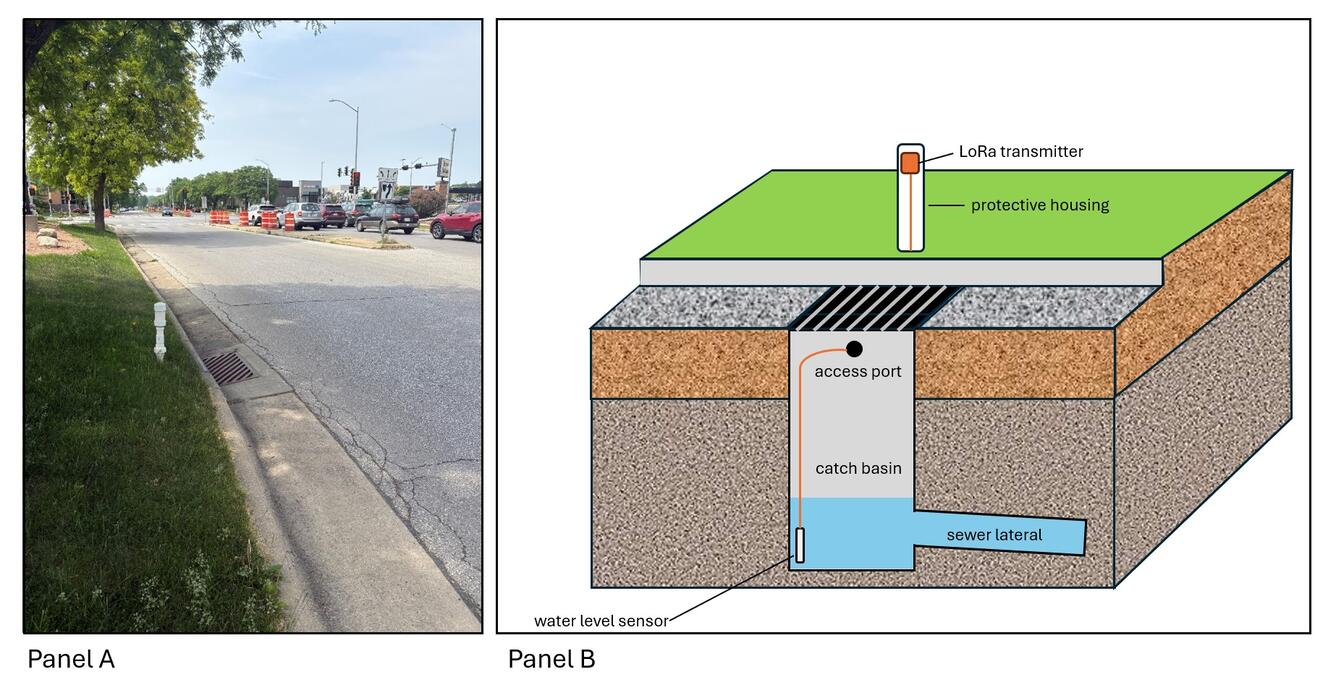
To overcome these barriers, a custom monitoring station was developed for deployment in urban areas with limited access to underground storm sewers. Figure 2 illustrates a typical flood monitoring point in the Madison pilot area. A LoRa configured device is nested within a protective housing placed adjacent to the street curb. The housing protects the LoRa device from dust and rain while allowing for quick access. It also satisfies a city request to not create a barrier should a vehicle accidentally strike it as well as to allow for quick removal during winter months so as not to get damaged by snowplows. A submersible pressure transducer connected to the LoRa device is routed from the housing, underneath the curb, and into an adjacent storm sewer inlet where it is securely fastened to the wall of the inlet catch basin. This configuration allows for safe and easy installation and maintenance of both the device and sensor. Water levels measured in the catch basin are compared to the street surface elevation to establish a threshold that automatically triggers alerts of impending flood conditions.
Submersible pressure transducers were selected for monitoring water levels in storm sewers because they provide reliable measurements of rapidly changing conditions. Other urban flood detection networks use ultrasonic sensors placed above ground on light poles, traffic signs, or other structures. Ultrasonic sensors estimate water depth by bouncing sound waves off the water surface. These devices are often compromised in high-moisture environments where condensation, fog, or splashing from passing vehicles can distort readings. They are also susceptible to interference from insects or debris that obstruct the sensor. More importantly, ultrasonic sensors installed above road level only begin to measure water depth once water has already reached the roadway. At that point, flooding is already in progress and the opportunity for early warning is lost. In contrast, submersible pressure transducers are installed directly within the sewer system, where they can detect rising water levels before the road surface is breached. This capability is critical, as even a few minutes of lead time can improve emergency response during flash flood events.
Creating a Real-time Flood Extent Viewer
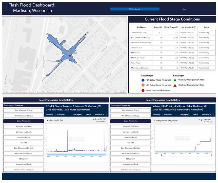
Once data from the network is transmitted to the cloud, they are forwarded to publicly accessible USGS databases and integrated into tailored web applications that can more effectively communicate flood status in real time. This allows for rapid translation of data into actionable information by decision makers and the public. For example, populating sensor data into a custom GIS dashboard can help users visualize the important hydrologic trends specific to the scope of a small urban watershed, such as localized rainfall intensity and flood inundation of individual neighborhoods.
The USGS has created a custom GIS web dashboard using ArcGIS Online to demonstrate how these types of sensor networks can be integrated into external data visualization platforms but also serve as preliminary application for the monitoring network in the City of Madison. The dashboard displays current water level data and the respective flood stage for each site in a concise table, where the flood stage is defined as the relative elevation to the road surface immediately above the water level sensor in the storm sewer. The dashboard also includes time-series graphs of cumulative precipitation within different watersheds in the city. Alternatively, users can view the data through an interactive map which displays the locations of each stage and precipitation gage and shows the current sensor readings when a monitoring location is selected. During a flood event where the water level has exceeded the road surface, the map will also display the elevation contour of the ground surface that is approximately equal to the current elevation derived from the stage sensor, effectively identifying the low-lying areas that could be impacted at that flood stage.
All dashboard elements are dynamically populated by programmatic triggers on the cloud platform that ingests and handles sensor data. This workflow combines these scalable data flows in the cloud with pre-built visualization tools of services like ArcGIS Online, providing a way to make these data more accessible through custom web applications.
By integrating these innovative, low-cost technologies, the USGS can provide a cost-effective, scalable monitoring network that improves situational awareness of urban flash flooding in real time. The system demonstrates how emerging IoT tools can help cities adapt to more frequent extreme rainfall events by turning vulnerable drainage points into sources of actionable information.
References
Acosta-Coll, M., Ballester-Merelo, F., Martinez-Peiro, M., and De la Hoz-Franco, E., 2018. Real-time early warning system design for pluvial flashfloods – A review, Sensors, 18(7), 2255, 26 p., https://doi.org/10.3390/s18072255
ForecastWatch, 2025. A record amount of flash flood warnings, available at: https://forecastwatch.com/2025/07/24/a-record-amount-of-flash-flood-warnings/, accessed on August 26, 2025.
Gimeno, L., Sori, R., Vazquez, M., Stojanovic, M., Algarra, I., Eiras-Barca, J., Gimeno-Sotelo, L., and Nieto, R., 2022. Extreme precipitation events, WiresWater, 9(6), 21 p., https://doi.org/10.1002/wat2.1611
U.S. Environmental Protection Agency, 2025. Climate change indicators: Heavy precipitation, available at: https://www.epa.gov/climate-indicators/climate-change-indicators-heavy-precipitation, accessed on August 26, 2025.
Flooding in urban areas is a serious weather-related threat to life and property. One type of flooding, called pluvial flooding, occurs during periods of intense rainfall where runoff overwhelms the capacity of soil to absorb it. In urban areas, pluvial flooding can be particularly dangerous because much of a city is covered by impervious surfaces such as streets, roofs, and parking lots forcing runoff to rapidly enter drainage networks faster than they are designed to carry it away. Unlike floods from rivers or the oceans, which can build up over hours or days, pluvial floods can occur quickly, sometimes in just minutes, leaving little time to react. Pluvial floods are also difficult to predict at the hyperlocal scale needed to better prepare emergency response personnel.
As cities continue to expand and stormwater infrastructure ages, the likelihood of drainage systems becoming overwhelmed continues to increase, leaving urban areas more exposed to damage from extreme storms (Acosta-Coll and others, 2018; Gimeno and others, 2022). The risks may be amplified by long-term climate trends. The U.S Environmental Protection Agency has shown extreme one-day precipitation events in the United States have steadily increased since 1970 (U. S. Environmental Protection Agency, 2025). The seriousness of this trend became clear in 2025, when the National Weather Service issued a record number of flash flood warnings, the highest in nearly four decades (ForecastWatch, 2025).
In 2018, the City of Madison, like many other communities across the U.S., experienced an extreme precipitation event that caused major flood damage. Since 2018, the city has initiated a variety of flood mitigation projects and watershed modeling studies to address widespread deficiencies in their stormwater conveyance system. In 2021, the U.S. Geological Survey began developing a low-cost flash flood detection and early warning network for the City of Madison as part of the Next Generation Water Observing Systems program (NGWOS). The network was intended to provide city engineers advance warning of impending flood conditions at select locations throughout the city to help reduce delay in response.
Selecting Equipment that Meets the Demands of Urban Street Flooding
USGS worked closely with city engineers to identify select areas that were most vulnerable to flooding. Low-cost Internet-of-Things (IoT) devices equipped with submersible pressure transducers were then installed at each location to measure real-time water levels inside storm sewers while remaining safely outside traffic corridors. The IoT devices selected for this study transmit data using a hybrid communication system that combines long-range wide area network (LoRaWAN) radio technology with Message Queuing Telemetry Transport (MQTT) messaging. LoRa is a low-power, long-range wireless communication protocol well suited for sending small packets of data. Its ability to reliably transmit data over long distances while consuming minimal energy makes it an ideal choice for urban flood monitoring where sensors must have a small footprint, long battery life, and remain in place for extended periods.
Each LoRa device is programmed to record and transmit water level measurements every five minutes. Data are sent via radio frequency to a nearby LoRa gateway, which acts as a relay point. The gateway then forwards the data to a cloud-based server, where it can be stored, analyzed, and accessed in real time. This approach makes it possible to collect information simultaneously from many sensors deployed across an urban catchment, creating a dense monitoring network (figure 1).
While LoRa technology is well suited for long-distance, low-power data transmission, its effectiveness can be limited by local topography and physical barriers. For example, steep terrain, building density, or underground locations may prevent signals from reliably reaching a gateway. In areas where LoRa coverage was limited or unreliable, cellular-enabled sensors were deployed instead. These devices bypass the gateway entirely by transmitting water level data directly to the cloud server using existing cellular networks (figure 1). By combining LoRa-based sensors with cellular-enabled devices, the monitoring network can provide coverage of vulnerable areas. This hybrid approach allows for flexible deployment across varied urban landscapes.
Overcoming the Challenge of Monitoring Urban Landscapes
Monitoring water levels in storm sewers presents unique challenges that limit the use of traditional gauging equipment. Unlike open streams or rivers, storm sewers are located underground and are often accessible only through manholes situated in the middle of busy streets. Traditional monitoring systems, which typically require more energy and frequent maintenance, are therefore not practical in these settings.
To overcome these barriers, a custom monitoring station was developed for deployment in urban areas with limited access to underground storm sewers. Figure 2 illustrates a typical flood monitoring point in the Madison pilot area. A LoRa configured device is nested within a protective housing placed adjacent to the street curb. The housing protects the LoRa device from dust and rain while allowing for quick access. It also satisfies a city request to not create a barrier should a vehicle accidentally strike it as well as to allow for quick removal during winter months so as not to get damaged by snowplows. A submersible pressure transducer connected to the LoRa device is routed from the housing, underneath the curb, and into an adjacent storm sewer inlet where it is securely fastened to the wall of the inlet catch basin. This configuration allows for safe and easy installation and maintenance of both the device and sensor. Water levels measured in the catch basin are compared to the street surface elevation to establish a threshold that automatically triggers alerts of impending flood conditions.
Submersible pressure transducers were selected for monitoring water levels in storm sewers because they provide reliable measurements of rapidly changing conditions. Other urban flood detection networks use ultrasonic sensors placed above ground on light poles, traffic signs, or other structures. Ultrasonic sensors estimate water depth by bouncing sound waves off the water surface. These devices are often compromised in high-moisture environments where condensation, fog, or splashing from passing vehicles can distort readings. They are also susceptible to interference from insects or debris that obstruct the sensor. More importantly, ultrasonic sensors installed above road level only begin to measure water depth once water has already reached the roadway. At that point, flooding is already in progress and the opportunity for early warning is lost. In contrast, submersible pressure transducers are installed directly within the sewer system, where they can detect rising water levels before the road surface is breached. This capability is critical, as even a few minutes of lead time can improve emergency response during flash flood events.
Creating a Real-time Flood Extent Viewer
Once data from the network is transmitted to the cloud, they are forwarded to publicly accessible USGS databases and integrated into tailored web applications that can more effectively communicate flood status in real time. This allows for rapid translation of data into actionable information by decision makers and the public. For example, populating sensor data into a custom GIS dashboard can help users visualize the important hydrologic trends specific to the scope of a small urban watershed, such as localized rainfall intensity and flood inundation of individual neighborhoods.
The USGS has created a custom GIS web dashboard using ArcGIS Online to demonstrate how these types of sensor networks can be integrated into external data visualization platforms but also serve as preliminary application for the monitoring network in the City of Madison. The dashboard displays current water level data and the respective flood stage for each site in a concise table, where the flood stage is defined as the relative elevation to the road surface immediately above the water level sensor in the storm sewer. The dashboard also includes time-series graphs of cumulative precipitation within different watersheds in the city. Alternatively, users can view the data through an interactive map which displays the locations of each stage and precipitation gage and shows the current sensor readings when a monitoring location is selected. During a flood event where the water level has exceeded the road surface, the map will also display the elevation contour of the ground surface that is approximately equal to the current elevation derived from the stage sensor, effectively identifying the low-lying areas that could be impacted at that flood stage.
All dashboard elements are dynamically populated by programmatic triggers on the cloud platform that ingests and handles sensor data. This workflow combines these scalable data flows in the cloud with pre-built visualization tools of services like ArcGIS Online, providing a way to make these data more accessible through custom web applications.
By integrating these innovative, low-cost technologies, the USGS can provide a cost-effective, scalable monitoring network that improves situational awareness of urban flash flooding in real time. The system demonstrates how emerging IoT tools can help cities adapt to more frequent extreme rainfall events by turning vulnerable drainage points into sources of actionable information.
References
Acosta-Coll, M., Ballester-Merelo, F., Martinez-Peiro, M., and De la Hoz-Franco, E., 2018. Real-time early warning system design for pluvial flashfloods – A review, Sensors, 18(7), 2255, 26 p., https://doi.org/10.3390/s18072255
ForecastWatch, 2025. A record amount of flash flood warnings, available at: https://forecastwatch.com/2025/07/24/a-record-amount-of-flash-flood-warnings/, accessed on August 26, 2025.
Gimeno, L., Sori, R., Vazquez, M., Stojanovic, M., Algarra, I., Eiras-Barca, J., Gimeno-Sotelo, L., and Nieto, R., 2022. Extreme precipitation events, WiresWater, 9(6), 21 p., https://doi.org/10.1002/wat2.1611
U.S. Environmental Protection Agency, 2025. Climate change indicators: Heavy precipitation, available at: https://www.epa.gov/climate-indicators/climate-change-indicators-heavy-precipitation, accessed on August 26, 2025.