Groundwater Model Support for Underground Injection Control Analysis, Pierce County, Washington
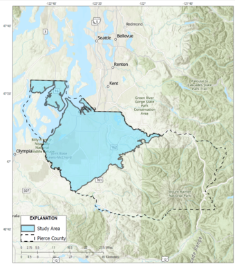
The Issue: In Pierce County, Washington, much of the stormwater runoff is managed by underground injection control (UIC) structures, such as dry wells, infiltration trenches, and catch basins. Stormwater is directed into UIC structures to prevent poor-quality water from entering streams. This is good for stream health because stormwater is directed away from streams and into the ground, but there is potential to degrade groundwater quality when water that exits UIC structures enters the unsaturated zone and percolates toward the water table. It is a regulatory requirement to have adequate vertical distance between the bottom of the UIC structure and the water table to provide the time and distance for filtration and attenuation of contaminants and sediments. Since the depth of the water table cannot be measured unless a well is present, a method is needed to estimate this depth at all existing and potential locations of UIC structures.
How USGS will help: Simulations of the water table available from groundwater flow models, together with measured water levels in wells, will be used to estimate the depths of the highest and average levels of the water table within the study area.
Problem: A critical parameter related to the regulatory requirements of underground injection control (UIC) structures that collect stormwater runoff is the vertical distance between the bottom of the structure and the water table. However, the depth of the water table cannot be measured unless a well is present.

Objectives: Objectives are to estimate the minimum and the average depths of the water table below the land surface at all locations within the study area and to create geospatial datasets of water table depths in digital format.
Relevance and Benefits: Results of the study will provide local communities, water resource managers, and natural resource agencies with information regarding expected depths to shallow groundwater, which is useful for managing groundwater availability, the interaction of groundwater and surface water, and stormwater UIC.
Approach: Groundwater model simulations will provide initial estimates of water table depths for the analysis. To provide optimum data-driven estimates of these depths, bias correction will be applied to model output to adjust for model bias of simulated water tables that are higher or lower than corresponding water level records.
Southeast Sound Groundwater Flow Model
Chambers-Clover Model
High and average water table estimates for Clover Creek watershed, Pierce County, Washington High and average water table estimates for Clover Creek watershed, Pierce County, Washington
The Issue: In Pierce County, Washington, much of the stormwater runoff is managed by underground injection control (UIC) structures, such as dry wells, infiltration trenches, and catch basins. Stormwater is directed into UIC structures to prevent poor-quality water from entering streams. This is good for stream health because stormwater is directed away from streams and into the ground, but there is potential to degrade groundwater quality when water that exits UIC structures enters the unsaturated zone and percolates toward the water table. It is a regulatory requirement to have adequate vertical distance between the bottom of the UIC structure and the water table to provide the time and distance for filtration and attenuation of contaminants and sediments. Since the depth of the water table cannot be measured unless a well is present, a method is needed to estimate this depth at all existing and potential locations of UIC structures.
How USGS will help: Simulations of the water table available from groundwater flow models, together with measured water levels in wells, will be used to estimate the depths of the highest and average levels of the water table within the study area.
Problem: A critical parameter related to the regulatory requirements of underground injection control (UIC) structures that collect stormwater runoff is the vertical distance between the bottom of the structure and the water table. However, the depth of the water table cannot be measured unless a well is present.

Objectives: Objectives are to estimate the minimum and the average depths of the water table below the land surface at all locations within the study area and to create geospatial datasets of water table depths in digital format.
Relevance and Benefits: Results of the study will provide local communities, water resource managers, and natural resource agencies with information regarding expected depths to shallow groundwater, which is useful for managing groundwater availability, the interaction of groundwater and surface water, and stormwater UIC.
Approach: Groundwater model simulations will provide initial estimates of water table depths for the analysis. To provide optimum data-driven estimates of these depths, bias correction will be applied to model output to adjust for model bias of simulated water tables that are higher or lower than corresponding water level records.


