
Groundwater/surface-water interaction within the South Fork Nooksack River Basin
The USGS, in partnership with the Nooksack Indian Tribe, is gathering information to better understand the connections between streams, wetlands, and groundwater in the South Fork Nooksack River Basin.
The Nooksack River flows from the Cascade Mountains to the Puget Sound in northwest Washington State. It supports a rich landscape of wetlands and riparian habitat, and supplies water to farms and communities. The river and its tributaries provide critical aquatic habitat for culturally important fish, including salmon.
Better scientific information is needed to understand how water flows through the ground and in rivers. USGS is collecting data and characterizing the hydrogeology of the South Fork Nooksack River Basin, which lays the groundwork for future development of a groundwater model that would allow water resource managers to simulate different scenarios and guide management decisions.
Motivation
The Nooksack River, along with its tributaries and ecosystems, faces increasing pressure from water demands, flood protection, and riverside land development. The pressures are exacerbated on the South Fork Nooksack River because it is not fed by glaciers, and instead, is dependent on groundwater inflows to keep the river cool.
Endangered salmon and other aquatic life need cool water to thrive. Warm water temperatures in the South Fork Nooksack are a limiting factor for salmon restoration. Groundwater can serve as a source of cool water where it naturally flows into and out of streams and wetlands.
USGS is working to improve our understanding of where and how groundwater and surface water interact in the South Fork Nooksack River Basin. This information will aid planning efforts to restore natural temperature regimes for salmon, as well as ensure water availability for the future.
Objective
This study is the first phase of a multi-phase effort with the overarching goal of producing a numerical groundwater-flow model that water resource managers can use to evaluate different management scenarios. It builds on an initial hydrogeologic assessment completed in 2014.
The objective of Phase 1 is to collect and develop all underlying data and other supporting information needed to construct a numerical groundwater-flow model.
Approach
Phase 1 is divided into three tasks: collecting new data, developing a hydrogeologic framework, and estimating a groundwater budget.
Data collection
We will acquire new hydrologic, well, streamflow, and wetland data to support future modeling.
- Streamgage Installation and Operation
- Media
 Sources/Usage: Public Domain. View Media Details
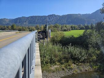
Non-contact radar sensor installed at USGS Station 12210485. Real-time data are available at: South Fork Nooksack River Above Potter Bridge at Van Zandt, WA. - USGS installed new monitoring equipment at South Fork Nooksack River Above Potter Bridge at Van Zandt, WA. Follow the link to view real-time water data.
- Well Inventory and Measurements
- Compile groundwater well database.
- Visit wells and measure the groundwater level where possible.
- Select a subset of wells to be measured monthly for two years.
- Discrete Streamflow Measurements
- Collect monthly discharge measurements near the headwaters of the Samish River
- Wetland Inventory and Observations
- Identify and measure water levels in wetlands, monthly for two years.
- Apply remote-sensing methods to identify and characterize wetlands and ponds
Hydrogeologic Framework
We will use the data collected to build a 3D hydrogeologic framework model of the South Fork Nooksack River Basin. Our approach will include:
- Review and Reassess Hydrogeologic Units published in the 2014 report.
- Construct 3D Hydrogeologic Framework Model
- Compile well logs, cross-sections, and new borehole data.
- Estimate continuous thickness/altitude of hydrogeologic units.
- Hydraulic Properties Compilation
- Summarize available aquifer parameters from prior studies, pumping tests, and drawdown data.
Groundwater Budget
We will estimate components of groundwater inflows/outflows to support future numerical modeling.
- Groundwater Use Estimation
- Develop monthly estimates of groundwater use.
- Lateral Groundwater Outflow
- Estimate groundwater outflow to the Samish River Valley using streamflow data and groundwater gradients.
- Baseflow Estimation
- Estimate monthly baseflow at four stream discharge stations.
- Recharge Estimation
- Run soil-water balance (SWB) model for 1980–2020.
- Adjust recharge estimates to balance baseflow.
- Compare results with two additional hydrology models (DHSVM and VELMA).
- Develop Groundwater Budget
- Assemble 10–15 year groundwater budget with water use, recharge, baseflow, and lateral outflows.
- Compare to long-term hydroclimatic conditions.
The USGS, in partnership with the Nooksack Indian Tribe, is gathering information to better understand the connections between streams, wetlands, and groundwater in the South Fork Nooksack River Basin.
The Nooksack River flows from the Cascade Mountains to the Puget Sound in northwest Washington State. It supports a rich landscape of wetlands and riparian habitat, and supplies water to farms and communities. The river and its tributaries provide critical aquatic habitat for culturally important fish, including salmon.
Better scientific information is needed to understand how water flows through the ground and in rivers. USGS is collecting data and characterizing the hydrogeology of the South Fork Nooksack River Basin, which lays the groundwork for future development of a groundwater model that would allow water resource managers to simulate different scenarios and guide management decisions.
Motivation
The Nooksack River, along with its tributaries and ecosystems, faces increasing pressure from water demands, flood protection, and riverside land development. The pressures are exacerbated on the South Fork Nooksack River because it is not fed by glaciers, and instead, is dependent on groundwater inflows to keep the river cool.
Endangered salmon and other aquatic life need cool water to thrive. Warm water temperatures in the South Fork Nooksack are a limiting factor for salmon restoration. Groundwater can serve as a source of cool water where it naturally flows into and out of streams and wetlands.
USGS is working to improve our understanding of where and how groundwater and surface water interact in the South Fork Nooksack River Basin. This information will aid planning efforts to restore natural temperature regimes for salmon, as well as ensure water availability for the future.
Objective
This study is the first phase of a multi-phase effort with the overarching goal of producing a numerical groundwater-flow model that water resource managers can use to evaluate different management scenarios. It builds on an initial hydrogeologic assessment completed in 2014.
The objective of Phase 1 is to collect and develop all underlying data and other supporting information needed to construct a numerical groundwater-flow model.
Approach
Phase 1 is divided into three tasks: collecting new data, developing a hydrogeologic framework, and estimating a groundwater budget.
Data collection
We will acquire new hydrologic, well, streamflow, and wetland data to support future modeling.
- Streamgage Installation and Operation
- Media
Sources/Usage: Public Domain. View Media Details
Non-contact radar sensor installed at USGS Station 12210485. Real-time data are available at: South Fork Nooksack River Above Potter Bridge at Van Zandt, WA. - USGS installed new monitoring equipment at South Fork Nooksack River Above Potter Bridge at Van Zandt, WA. Follow the link to view real-time water data.
- Well Inventory and Measurements
- Compile groundwater well database.
- Visit wells and measure the groundwater level where possible.
- Select a subset of wells to be measured monthly for two years.
- Discrete Streamflow Measurements
- Collect monthly discharge measurements near the headwaters of the Samish River
- Wetland Inventory and Observations
- Identify and measure water levels in wetlands, monthly for two years.
- Apply remote-sensing methods to identify and characterize wetlands and ponds
Hydrogeologic Framework
We will use the data collected to build a 3D hydrogeologic framework model of the South Fork Nooksack River Basin. Our approach will include:
- Review and Reassess Hydrogeologic Units published in the 2014 report.
- Construct 3D Hydrogeologic Framework Model
- Compile well logs, cross-sections, and new borehole data.
- Estimate continuous thickness/altitude of hydrogeologic units.
- Hydraulic Properties Compilation
- Summarize available aquifer parameters from prior studies, pumping tests, and drawdown data.
Groundwater Budget
We will estimate components of groundwater inflows/outflows to support future numerical modeling.
- Groundwater Use Estimation
- Develop monthly estimates of groundwater use.
- Lateral Groundwater Outflow
- Estimate groundwater outflow to the Samish River Valley using streamflow data and groundwater gradients.
- Baseflow Estimation
- Estimate monthly baseflow at four stream discharge stations.
- Recharge Estimation
- Run soil-water balance (SWB) model for 1980–2020.
- Adjust recharge estimates to balance baseflow.
- Compare results with two additional hydrology models (DHSVM and VELMA).
- Develop Groundwater Budget
- Assemble 10–15 year groundwater budget with water use, recharge, baseflow, and lateral outflows.
- Compare to long-term hydroclimatic conditions.