
Hydrogeologic Framework for the Duwamish River Valley to the Lake Washington Ship Canal, Washington
The Issue:
King County has over 30 miles of coastline on the Puget Sound where coastal sea level rise and high tides can cause flooding. Many coastal areas have low elevations and are prone to flooding during high tides, extreme rainfall, and high streamflow. In addition, groundwater inundation—localized coastal flooding due to a rise of the groundwater table with global sea-level rise—may compound flooding issues in the area. In these coastal areas, there is extensive critical infrastructure located primarily on the land surface or buried in the shallow subsurface. Owing to the likelihood of a future rise in the groundwater table due to sea-level rise, this infrastructure may be at risk to groundwater inundation.
How USGS will help:
The objective of the study is to develop a detailed hydrogeologic framework and groundwater-recharge estimates for the area from the Duwamish River valley to the Lake Washington Ship Canal. This study will establish the framework necessary to construct a numerical groundwater model that could be used to simulate the effects of hydrologic conditions such as sea-level rise, tidal events, flooding events, and rainstorms on the groundwater table.
Plain Language Summary
Plain Language Summary Translations
- [Chinese] Washington 杜瓦米什河谷(Duwamish River valley) 地下水研究
- [Vietnamese] Nghiên cứu nước ngầm ở Thung Lũng Sông Duwamish, Washington
- [Somali] Daraasadda biyaha dhulka hoostiisa ee Duwamish River valley, Washington
- [Khmer] ការសិក្សាអំពីទឹក្សក្រកាមដីនៃររលង Duwamish River valley ទីរក្ស ុង Washin…
- [Spanish] Estudio de aguas subterráneas del Duwamish River valley, Washington
Problem
King County has over 30 miles of coastline on the Puget Sound where coastal sea level rise and high tides can cause flooding. Many coastal areas have low elevations and are prone to flooding during high tides, extreme rainfall, and high streamflow.
In addition, groundwater inundation—localized coastal flooding due to a rise of the groundwater table with global sea-level rise—may compound flooding issues in the area. In these coastal areas, there is extensive critical infrastructure located primarily on the land surface or buried in the shallow subsurface. Owing to the likelihood of a future rise in the groundwater table due to sea-level rise, this infrastructure may be at risk to groundwater inundation.
Objectives
The objective of the study is to develop a detailed hydrogeologic conceptual model and groundwater-recharge estimates for the Duwamish River valley to the Lake Washington Ship Canal. This study will establish the framework necessary to construct a numerical groundwater model that could be used to simulate the effects of hydrologic conditions such as sea-level rise, tidal events, flooding events, and rainstorms on the groundwater table and the distribution of salinity in the groundwater system.
Relevance and Benefits
Completion of the proposed work will provide foundational information to King County—along with water-resource managers and city planners in Seattle—that will inform and direct current and future actions to prepare for sea-level rise. This study will provide information that advances flood-inundation science and will also improve understanding of the groundwater system that plays a major role in the movement of contaminants to the Duwamish Waterway, a Federal Superfund site.
Approach
To meet the objective of this study, the approach will be split into four primary tasks:
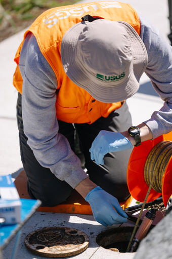
- Well inventory.
- Well-network planning, deployment, monitoring, and analysis.
- Estimation of groundwater recharge.
- Development of the hydrogeologic framework.
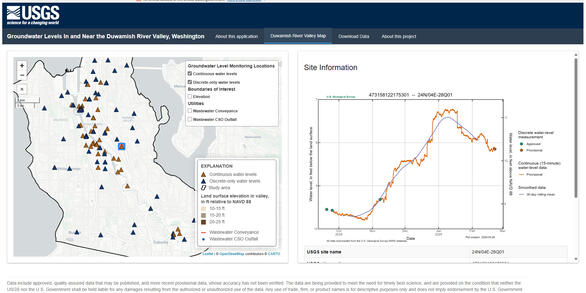
Hydrologic and geologic information from existing studies will be synthesized with new information from drillers’ well logs, groundwater-level measurements, groundwater-salinity measurements, and slug tests conducted at wells.
The first phase of the project focuses on the Duwamish river valley; a second phase expands the study area northward to the Lake Washington Ship Canal.
The Issue:
King County has over 30 miles of coastline on the Puget Sound where coastal sea level rise and high tides can cause flooding. Many coastal areas have low elevations and are prone to flooding during high tides, extreme rainfall, and high streamflow. In addition, groundwater inundation—localized coastal flooding due to a rise of the groundwater table with global sea-level rise—may compound flooding issues in the area. In these coastal areas, there is extensive critical infrastructure located primarily on the land surface or buried in the shallow subsurface. Owing to the likelihood of a future rise in the groundwater table due to sea-level rise, this infrastructure may be at risk to groundwater inundation.
How USGS will help:
The objective of the study is to develop a detailed hydrogeologic framework and groundwater-recharge estimates for the area from the Duwamish River valley to the Lake Washington Ship Canal. This study will establish the framework necessary to construct a numerical groundwater model that could be used to simulate the effects of hydrologic conditions such as sea-level rise, tidal events, flooding events, and rainstorms on the groundwater table.
Plain Language Summary
Plain Language Summary Translations
- [Chinese] Washington 杜瓦米什河谷(Duwamish River valley) 地下水研究
- [Vietnamese] Nghiên cứu nước ngầm ở Thung Lũng Sông Duwamish, Washington
- [Somali] Daraasadda biyaha dhulka hoostiisa ee Duwamish River valley, Washington
- [Khmer] ការសិក្សាអំពីទឹក្សក្រកាមដីនៃររលង Duwamish River valley ទីរក្ស ុង Washin…
- [Spanish] Estudio de aguas subterráneas del Duwamish River valley, Washington
Problem
King County has over 30 miles of coastline on the Puget Sound where coastal sea level rise and high tides can cause flooding. Many coastal areas have low elevations and are prone to flooding during high tides, extreme rainfall, and high streamflow.
In addition, groundwater inundation—localized coastal flooding due to a rise of the groundwater table with global sea-level rise—may compound flooding issues in the area. In these coastal areas, there is extensive critical infrastructure located primarily on the land surface or buried in the shallow subsurface. Owing to the likelihood of a future rise in the groundwater table due to sea-level rise, this infrastructure may be at risk to groundwater inundation.
Objectives
The objective of the study is to develop a detailed hydrogeologic conceptual model and groundwater-recharge estimates for the Duwamish River valley to the Lake Washington Ship Canal. This study will establish the framework necessary to construct a numerical groundwater model that could be used to simulate the effects of hydrologic conditions such as sea-level rise, tidal events, flooding events, and rainstorms on the groundwater table and the distribution of salinity in the groundwater system.
Relevance and Benefits
Completion of the proposed work will provide foundational information to King County—along with water-resource managers and city planners in Seattle—that will inform and direct current and future actions to prepare for sea-level rise. This study will provide information that advances flood-inundation science and will also improve understanding of the groundwater system that plays a major role in the movement of contaminants to the Duwamish Waterway, a Federal Superfund site.
Approach
To meet the objective of this study, the approach will be split into four primary tasks:
- Well inventory.
- Well-network planning, deployment, monitoring, and analysis.
- Estimation of groundwater recharge.
- Development of the hydrogeologic framework.
Hydrologic and geologic information from existing studies will be synthesized with new information from drillers’ well logs, groundwater-level measurements, groundwater-salinity measurements, and slug tests conducted at wells.
The first phase of the project focuses on the Duwamish river valley; a second phase expands the study area northward to the Lake Washington Ship Canal.