
USGS Liaison to U. S. Northern Command
The National Geospatial Program (NGP) houses the USGS Liaison to the North American Aerospace Defense (NORAD) and United States Northern Command (USNORTHCOM) jointly referred to as N-NC. The USGS Liaison to N-NC is assigned to the J35, Civil Support Division and is part of an Inter-agency team supporting N-NC.
The National Geospatial Program (NGP) houses the USGS Liaison to the North American Aerospace Defense (NORAD) and United States Northern Command (USNORTHCOM) jointly referred to as N-NC. USGS is assigned to the J35, Civil Support Division, and is part of an Inter-agency team supporting the Command. This USGS position supports numerous DOD activities to include:
Homeland Defense: The USGS provides liaison to the N-NC Commander and Staff. In this capacity the USGS Liaison facilitates the need for scientific information and data required for Homeland Defense. The USGS Liaison is routinely asked to provide the Command with science support for natural hazards events and request for hazards science information; coordinates support to DOD for hazards exercises / real-world disaster events and contingencies; provides geospatial products and services coordination; communicates and advocates for N-NC science issues regarding Civil Support & Humanitarian Assistance; and reviews the science within N/NC exercise plans.
Defense Support for Civil Authorities (DSCA) Support: The USGS Liaison provides coordination for USGS science products (Onepager / ShakeMap / other), and geospatial data and services for DOD DSCA events and exercises.
Humanitarian Assistance (HA) Support: The USGS Liaison facilitates the coordination of humanitarian project support for N-NC HA missions. Recent projects and events include the Nogales, MX., ALERT flood warning array project which provides storm preparedness and management data along the US/Mexico border. The USGS Liaison also supports the coordination of HA science exchange events for N-NC and foreign partners. Recent coordination includes the Mexican National Center for Prevention of Disasters (CENAPRED) science exchange visit to the USGS National Earthquake Information Center as well as a USGS Landslide Hazards Program Science Exchange field trip and the facilitation of a scientific equipment use agreement that will benefit both Mexican and US public safety.
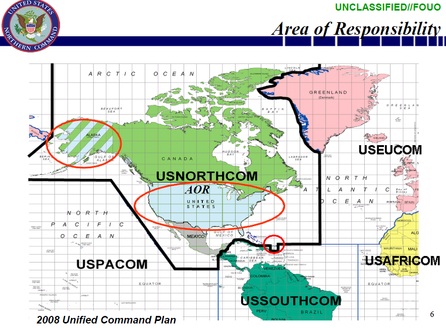
USNORTHCOM’s AOR includes air, land and sea approaches and encompasses the continental United States, Alaska, Canada, Mexico and the surrounding water out to approximately 500 nautical miles. It also includes the Gulf of Mexico, the Straits of Florida, and portions of the Caribbean region to include The Bahamas, Puerto Rico, and the U.S. Virgin Islands. The commander of USNORTHCOM is responsible for theater security cooperation with Canada, Mexico, and The Bahamas.