
Media used at EROS including high density tapes (HDT), computer compatible tapes (CCT), and digital cassette tapes (DCT). EROS History Project
Images
View images related to the history of the USGS Earth Resources Observation and Science (EROS) Center.
Filter Total Items: 358

1995 Media Used at EROS HDT CCT DCT 3480 8MM
Media used at EROS including high density tapes (HDT), computer compatible tapes (CCT), and digital cassette tapes (DCT). EROS History Project

1995 Building Addition Floor Prep
Building addition floor preparation that would later serve as the archive. EROS History Project
Building addition floor preparation that would later serve as the archive. EROS History Project

1994 USGS EROS building addition
Building addition at EROS. EROS History Project

1994 USGS EROS building addition close up
Building addition at EROS. EROS History Project

1994 September Building Addition
Building addition construction in September. EROS History Project
Building addition construction in September. EROS History Project

1994 Building Addition Atrium Girders
USGS EROS building addition atrium girders in 1994.
USGS EROS building addition atrium girders in 1994.

1994 October Building Addition A
USGS EROS building addition construction in October 1994
USGS EROS building addition construction in October 1994

1993 SAST River Flooding Image
Major flooding in the Midwest in 1993 led to the development of a special US science team, the Scientific Assessment and Strategy Team (SAST).
Major flooding in the Midwest in 1993 led to the development of a special US science team, the Scientific Assessment and Strategy Team (SAST).

1993 Scientific Assessment and Strategy Team SAST Meeting
1993 Scientific Assessment and Strategy Team SAST MeetingThe Scientific Assessment and Strategy Team (SAST) Meeting in the USGS EROS Data Center's main conference room.
1993 Scientific Assessment and Strategy Team SAST Meeting
1993 Scientific Assessment and Strategy Team SAST MeetingThe Scientific Assessment and Strategy Team (SAST) Meeting in the USGS EROS Data Center's main conference room.

1993 Global Land 1-Kilometer AVHRR Composite
USGS EROS science staff developed a 1-Km resolution global land perspective using NOAA’s AVHRR data.
USGS EROS science staff developed a 1-Km resolution global land perspective using NOAA’s AVHRR data.

Screenshot of 1992 Land Remote Sensing Policy Act Congressional Record
Screenshot of 1992 Land Remote Sensing Policy Act Congressional RecordThis is a screenshot of 1992 Land Remote Sensing Policy Act Congressional Record. The full document is available below.
Screenshot of 1992 Land Remote Sensing Policy Act Congressional Record
Screenshot of 1992 Land Remote Sensing Policy Act Congressional RecordThis is a screenshot of 1992 Land Remote Sensing Policy Act Congressional Record. The full document is available below.
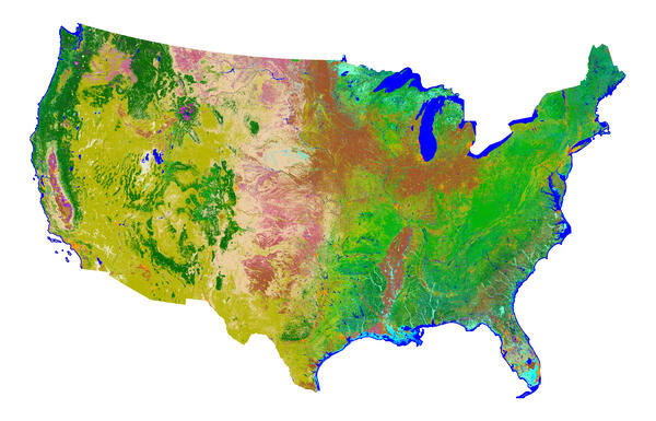
NLCD 1992
The first National Land Cover Dataset (NLCD), based on Landsat 5 data, is completed and available for distribution in 2000.
The first National Land Cover Dataset (NLCD), based on Landsat 5 data, is completed and available for distribution in 2000.

1991 AVHRR Composite of Alaska
1991 AVHRR Composite of Alaska - EROS History Project
1991 AVHRR Composite of Alaska - EROS History Project

1991 International Space Year Workshop
1991 photo from International Space Year workshop - EROS History Project
1991 photo from International Space Year workshop - EROS History Project

1991 Kuwait Oil Fires
1991 Kuwait Oil Fires - EROS History Project
1991 Kuwait Oil Fires - EROS History Project

1990 Landsat Scene Counts
1990 Landsat Scene Counts - EROS History Project
1990 Landsat Scene Counts - EROS History Project

1990 Map of US Greenness Classes
1990 Map of US Greenness Classes - EROS History Project
1990 Map of US Greenness Classes - EROS History Project

1990 Middle East Mosaic With Persian Gulf, Red Sea, Mediterranean Sea
1990 Middle East Mosaic With Persian Gulf, Red Sea, Mediterranean Sea1990 Middle East Mosaic showing Persian Gulf, Red Sea, Mediterranean Sea - AVHRR - EROS History Project
1990 Middle East Mosaic With Persian Gulf, Red Sea, Mediterranean Sea
1990 Middle East Mosaic With Persian Gulf, Red Sea, Mediterranean Sea1990 Middle East Mosaic showing Persian Gulf, Red Sea, Mediterranean Sea - AVHRR - EROS History Project

1990 EROS Lobby
1990 EROS Lobby - EROS History Project

1990s High Density Tape HDT oven
1990s High Density Tape HDT oven - EROS History Project
1990s High Density Tape HDT oven - EROS History Project

1990 Planet Earth Inauguration
1990 Planet Earth Inauguration - EROS History Project
1990 Planet Earth Inauguration - EROS History Project