
How does data from Sentinel-2A’s MultiSpectral Instrument compare to Landsat data?
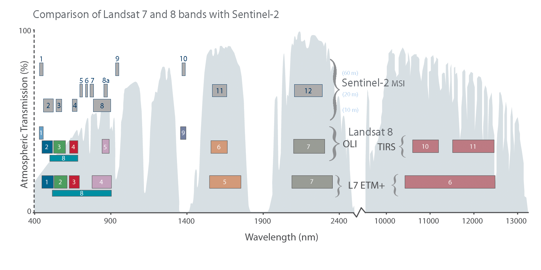
The Sentinel-2A MultiSpectral Instrument (MSI) data has spectral bands very similar to Landsat 8 and 9 (excluding the thermal bands of Thermal Infrared Sensor (TIRS)).

All Sentinel-2 data are freely available from the Copernicus Open Access Hub; therefore, users are encouraged to download the data via https://dataspace.copernicus.eu/explore-data/data-collections/sentinel-data/sentinel-2. To learn more about the Sentinel satellite and data, information is available from https://www.esa.int/Applications/Observing_the_Earth/Copernicus/Sentinel-2. If you have questions on how to access the data from Copernicus please contact their support team using their Get in Touch website which provides an email form, email address and phone number.
Learn more: USGS EROS Sentinel-2 Landsat Comparison
Related

What are U.S. Landsat Analysis Ready Data (ARD)? What are U.S. Landsat Analysis Ready Data (ARD)?
U.S. Landsat Analysis Ready Data (ARD) are pre-packaged and pre-processed bundles of Landsat data products that make the Landsat archive more accessible and easier to analyze, and reduce the amount of time users spend on data processing for time-series analysis. ARD contains Level-2 products derived from Landsat Collections Level-1 scenes. ARD are tiled, georegistered, top of atmosphere, and...

Why do Landsat 7 Level-1 products contain two thermal bands? Why do Landsat 7 Level-1 products contain two thermal bands?
Landsat 7 acquired thermal data in two bands from one detector in both high (Band 6H) and low (Band 6L) gain. The difference in gain settings is important to different types of studies (i.e., clouds vs. deserts). Aside from the resolution differences and saturation on the high and low ends, the two bands provide the same Digital Numbers (DN) for every pixel. FILE_NAME_BAND_6_VCID_1 (band 61 or 6L)...
Related
What are U.S. Landsat Analysis Ready Data (ARD)? What are U.S. Landsat Analysis Ready Data (ARD)?
U.S. Landsat Analysis Ready Data (ARD) are pre-packaged and pre-processed bundles of Landsat data products that make the Landsat archive more accessible and easier to analyze, and reduce the amount of time users spend on data processing for time-series analysis. ARD contains Level-2 products derived from Landsat Collections Level-1 scenes. ARD are tiled, georegistered, top of atmosphere, and...
Why do Landsat 7 Level-1 products contain two thermal bands? Why do Landsat 7 Level-1 products contain two thermal bands?
Landsat 7 acquired thermal data in two bands from one detector in both high (Band 6H) and low (Band 6L) gain. The difference in gain settings is important to different types of studies (i.e., clouds vs. deserts). Aside from the resolution differences and saturation on the high and low ends, the two bands provide the same Digital Numbers (DN) for every pixel. FILE_NAME_BAND_6_VCID_1 (band 61 or 6L)...