
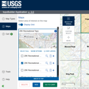
The U.S. Geological Survey’s National Geospatial Program has released the topoBuilder application, which enables users to create topographic maps on demand using the best available National Map data.
Why is the orthoimage (air photo) layer not available for some US Topo maps and OnDemand Topo maps?
In the lower 48 States, orthoimages (rectified air photographs) for US Topo maps and OnDemand Topo maps comes from the National Agriculture Imagery Program (NAIP). There are areas over some military installations where NAIP imagery is not available. In these locations, the OnDemand Topo maps will either not include imagery or contain partial imagery. US Topo maps are only produced for areas that have at least partial image coverage.
Areas with incomplete imagery include:
- Edwards Air Force Base, CA
-
Nellis Air Force Base, Nevada National Security Site (Area 51), NV
-
Eglin Air Force Base, FL
-
Fort Bragg Military Reservation, NC
-
Aberdeen Proving Ground, MS
Related

How do I download orthoimagery products and what are the available formats? How do I download orthoimagery products and what are the available formats?
Download orthoimagery (georectified aerial photographs) using EarthExplorer, which has the full catalog of USGS orthoimagery and aerial photography. EarthExplorer: Products Overview Format varies by type of orthoimagery: Native format, Georeferenced Tagged Image File Format (GeoTIFF), or compressed 10:1 JPEG2000 A NAIP orthoimage is included as an optional layer in the PDF format of digital...

How often is orthoimagery in The National Map updated and what are the acquisition dates? How often is orthoimagery in The National Map updated and what are the acquisition dates?
Orthoimagery (georectified aerial photography) available through The National Map Downloader and The National Map Services is from the USDA Farm Service Agency's National Agricultural Imagery Program (NAIP), which is 1-meter resolution. Generally, NAIP imagery is refreshed on a 3-year cycle with approximately one third of the continental U.S. flown each year. The month and year of imagery...

What is a digital orthophoto quadrangle (DOQ) or orthoimage? What is a digital orthophoto quadrangle (DOQ) or orthoimage?
A digital orthophoto quadrangle (DOQ)--or any orthoimage--is a computer-generated image of an aerial photograph in which displacements (distortions) caused by terrain relief and camera tilts have been removed. It combines the image characteristics of a photograph with the geometric qualities of a map. Unlike an aerial photograph, an orthoimage has a uniform scale, so it can be used as a base map...
How do USGS OnDemand Topo maps differ from US Topo maps? How do USGS OnDemand Topo maps differ from US Topo maps?
USGS OnDemand Topo maps and USGS US Topo maps are built using similar datasets but can look different depending on what areas or options the user selects. OnDemand Topos--created using the topoBuilder application--offer customizations such as custom extents, a variety of scales, contour smoothing, and user-selected data layers. They include U.S. Territory coverage that is not available on US...

Are there metadata files for USGS topographic maps? Are there metadata files for USGS topographic maps?
GeoPDF files for both Historical Topographic maps (produced 1884-2006), US Topo maps (produced 2009-present), and OnDemand Topo maps come with an XML metadata file attached to each GeoPDF file. To access the metadata file, download the GeoPDF file, open it in Acrobat Reader, click on the paperclip icon, then select a file from the list that appears (US Topo maps also come with a Map Symbols sheet...

topoBuilder: OnDemand, Custom, Topographic Maps
The U.S. Geological Survey’s National Geospatial Program has released the topoBuilder application, which enables users to create topographic maps on demand using the best available National Map data.

topoBuilder Infographic
topoBuilder & OnDemand Topo Capabilities
topoBuilder & OnDemand Topo Capabilities
Related
How do I download orthoimagery products and what are the available formats? How do I download orthoimagery products and what are the available formats?
Download orthoimagery (georectified aerial photographs) using EarthExplorer, which has the full catalog of USGS orthoimagery and aerial photography. EarthExplorer: Products Overview Format varies by type of orthoimagery: Native format, Georeferenced Tagged Image File Format (GeoTIFF), or compressed 10:1 JPEG2000 A NAIP orthoimage is included as an optional layer in the PDF format of digital...
How often is orthoimagery in The National Map updated and what are the acquisition dates? How often is orthoimagery in The National Map updated and what are the acquisition dates?
Orthoimagery (georectified aerial photography) available through The National Map Downloader and The National Map Services is from the USDA Farm Service Agency's National Agricultural Imagery Program (NAIP), which is 1-meter resolution. Generally, NAIP imagery is refreshed on a 3-year cycle with approximately one third of the continental U.S. flown each year. The month and year of imagery...
What is a digital orthophoto quadrangle (DOQ) or orthoimage? What is a digital orthophoto quadrangle (DOQ) or orthoimage?
A digital orthophoto quadrangle (DOQ)--or any orthoimage--is a computer-generated image of an aerial photograph in which displacements (distortions) caused by terrain relief and camera tilts have been removed. It combines the image characteristics of a photograph with the geometric qualities of a map. Unlike an aerial photograph, an orthoimage has a uniform scale, so it can be used as a base map...
How do USGS OnDemand Topo maps differ from US Topo maps? How do USGS OnDemand Topo maps differ from US Topo maps?
USGS OnDemand Topo maps and USGS US Topo maps are built using similar datasets but can look different depending on what areas or options the user selects. OnDemand Topos--created using the topoBuilder application--offer customizations such as custom extents, a variety of scales, contour smoothing, and user-selected data layers. They include U.S. Territory coverage that is not available on US...
Are there metadata files for USGS topographic maps? Are there metadata files for USGS topographic maps?
GeoPDF files for both Historical Topographic maps (produced 1884-2006), US Topo maps (produced 2009-present), and OnDemand Topo maps come with an XML metadata file attached to each GeoPDF file. To access the metadata file, download the GeoPDF file, open it in Acrobat Reader, click on the paperclip icon, then select a file from the list that appears (US Topo maps also come with a Map Symbols sheet...
topoBuilder: OnDemand, Custom, Topographic Maps
The U.S. Geological Survey’s National Geospatial Program has released the topoBuilder application, which enables users to create topographic maps on demand using the best available National Map data.
The U.S. Geological Survey’s National Geospatial Program has released the topoBuilder application, which enables users to create topographic maps on demand using the best available National Map data.
topoBuilder Infographic
topoBuilder & OnDemand Topo Capabilities
topoBuilder & OnDemand Topo Capabilities
Updated Date: July 7, 2022