
Center of Excellence for Geospatial Information Science (CEGIS) glossary
The CEGIS vision is to conduct, lead, and influence the research and innovative solutions required by the National Spatial Data Infrastructure (NSDI) and the emerging GeoSpatial and GeoSemantic Web.
CEGIS is a virtual organization with Federal and academic affiliate scientists conducting research in support of The National Map and the Three-Dimensional Elevation Program (3DEP).
0-9
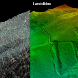
3D integrated terrain and hydrography
3D integrated terrain and hydrography
the generation of water-related features that align with the surrounding land in three dimensions
3DEP
3DEP
The 3D Elevation Program (3DEP) is high-quality topographic data for a wide range of other three-dimensional (3D) representations of the Nation's natural and constructed features.
A
AI
AI
Artificial intelligence (AI) lets computers learn from lots of data and use that knowledge to answer our questions based on logical patterns found in the data.
ALI
ALI
Advanced Land Imager (ALI) is the first Earth-Observing instrument to be flown under NASA's New Millennium Program (NMP). The ALI employs novel wide-angle optics and a highly integrated multispectral and panchromatic spectrometer.
ASTER
ASTER
The Advanced Spaceborne Thermal Emission and Reflection Radiometer (ASTER) is an imaging instrument onboard Terra, the flagship satellite of NASA's Earth Observing System (EOS) launched in December 1999.
Automated terrain mapping
Automated terrain mapping
identifying and classifying landscape features without requiring user-input parameters
B
BGN
BGN
The U.S. Board on Geographic Names (BGN), along with the Domestic Names Committee (DNC), is responsible for the Geographic Names Information System (GNIS), a database for place names within the United States and its dependent areas.
BISON
BISON
Biodiversity Information Serving our Nation (BISON) is when data from the USGS is integrated with digital geologic map data and The National Map (TNM) layers to provide geographic context for specimen location.
C
CEGIS
CEGIS
The Center of Excellence for Geospatial Information Science (CEGIS) is a virtual organization with Federal and academic affiliate scientists conducting research in support of The National Map (TNM) and the Three-Dimensional Elevation Program (3DEP).
Citizen Science
Citizen Science
the collective term given to the various opportunities available for the public to contribute to science and help advance scientific knowledge. Learn about current USGS and partner Citizen Science opportunities at https://www.usgs.gov/youth-and-education-in-science/citizen-science.
Conflation
Conflation
to combine two or more texts, ideas, etc. into one
Corps
Corps
The National Map Corps (TNMCorps) is an online crowdsourcing mapping project with volunteers successfully editing structures in all 50 States and the U.S. Territories.
D
Deep learning
Deep learning
Deep learning (DL) is a subset of Machine learning (ML), with the difference that DL algorithms can automatically learn representations from data such as images, video, or text, without introducing human domain knowledge.
Delineation
Delineation
the act of representing something with lines or words
DEM
DEM
A Digital Elevation Model (DEM) is a representation of the bare ground (bare earth) topographic surface of the Earth taken from lidar point cloud excluding trees, buildings, and any other surface objects.
DL
DL
Deep learning (DL) is a subset of Machine learning (ML), with the difference that DL algorithms can automatically learn representations from data such as images, video, or text, without introducing human domain knowledge.
DNC
DNC
The Domestic Names Committee (DNC) along with the U.S. Board on Geographic Names (BGN), is responsible for the Geographic Names Information System (GNIS), a database for place names within the United States and its dependent areas.
Domestic Names Database
Domestic Names Database
part of the Geographic Names Information System (GNIS) which stores official US geographic names data as they apply to Federal electronic and printed products
DSM
DSM
A digital surface model (DSM) is created using Light Detection and Ranging (lidar) technology and is useful in 3D modeling.
E
EDBAAT
EDBAAT
Elevation Difference and Bouguer Anomaly Analysis Tool (EDBAAT) integrates gravity data for a chosen geographic area in CONUS with The National Map elevation layer.
F
Feature extraction
Feature extraction
the process of identifying certain items of interest from geospatial data using specialized approaches, especially as it applies to computers and machine learning (ML)
Feature generalization
Feature generalization
grouping similar objects and simplifying them using a single term or classification, especially as it applies to geospatial data and how it can be represented on smaller scale maps
G
GeoAI
GeoAI
Geospatial artificial intelligence (GeoAI) is when artificial intelligence (AI) uses geospatial data, science, and technology to help analyze geographical information.
Geomorphic
Geomorphic
how something relates to the form of the landscape and other natural features of the earth's surface
GIS
GIS
A Geographic Information System (GIS) is a computer system that analyzes and displays geographically referenced information. It uses data that is attached to a unique location.
GNIS
GNIS
The Geographic Names Information System (GNIS) is a database for place names within the United States and its dependent areas and are the responsibility of the Domestic Names Committee (DNC) of the U.S. Board on Geographic Names (BGN).
GPU
GPU
A graphics processing unit (GPU) is the part of a computer that helps handle images and videos.
Graphics processing unit
Graphics processing unit
often called GPU, is the part of a computer that helps handle images and videos
Graphics processing units for mapping
Graphics processing units for mapping
the use of graphic processing units in improving run-time speeds in automated cartography
H
Henry Gannett Award
Henry Gannett Award
a USGS award given to nominees who have made substantial contributions to the advancement of geospatial sciences
Historical topographic features
Historical topographic features
when physical land characteristics are represented through text font and placement on maps which are out of date or depict a specific previous time period
HPC
HPC
High-performance computing (HPC) focuses on efficient processing of geospatial data in the supercomputing domain for the benefit of spatial analytics and spatial data handling.
Hydro-conditioning
Hydro-conditioning
the modification of topographic data to better represent elevation drops due to culverts and bridge locations to overcome when roads act as barriers that alter the natural drainage patterns and impact extracted drainage lines
Hydrography semantics
Hydrography semantics
used to describe the collection of terms used by scientists who study water features
I
IfSAR
IfSAR
Interferometric synthetic aperture radar (IfSAR) can penetrate clouds, smoke, and haze to collect data.
J
JSON
JSON
JavaScript Object Notation (JSON) is a lightweight data-interchange format. It is easy for humans to read and write. It is easy for machines to parse and generate.
L
Landscape characterization
Landscape characterization
the use of metrics or indices to sort visible features of land into different classes
Lidar
Lidar
Light Detection and Ranging (lidar) is a technology used to create high-resolution models of ground elevation. Lidar equipment, which includes a laser scanner, a Global Positioning System (GPS), and an Inertial Navigation System (INS), is typically mounted on a small aircraft and transmits brief pulses of light to the ground surface. Much like sound is used for echolocation, the lidar digital pulses are reflected or scattered back, and their travel time is used to calculate the distance between the laser scanner and the ground. This data is collected and cleaned up to produce accurate digital images.
LLM
LLM
A large language model (LLM) is the term given to the process a computer uses to "understand" and generate language humans can understand. It uses algorithms, patterns, and relationships within wide parameters.
LRS
LRS
Land Remote Sensing (LRS) is the collective term for processes that gather information about the earth's surface, such as satellite or aerial imagery.
M
Machine learning
Machine learning
Machine learning (ML) is a type of technology that uses algorithms to find patterns and make predictions based on examples, like recommending movies based on past preferences.
Map as a knowledge base
Map as a knowledge base
often shortened to "MapKB"; the term given to the idea that the visual map is more than simple data and design; it also includes written communication based on language and what actions that language conveys
Mapimg
Mapimg
MapImage, or mapimg, is an internal USGS software package for raster map projection transformation based on a graphical user interface for Windows, Linux, and other UNIX machines.
MapKB
MapKB
Map as a knowledge base (MapKB) is the term given to the idea that the visual map is more than simple data and design; it also includes written communication based on language and what actions that language conveys.
ML
ML
Machine learning (ML) is a type of technology that uses algorithms to find patterns and make predictions based on examples, like recommending movies based on past preferences.
MRR
MRR
Multi-Resolution Raster (MRR) is a technique to study two-dimensional scans taken at multiple resolutions and is the predecessor to High-performance computing (HPC)
N
NAIP
NAIP
The National Agriculture Imagery Program (NAIP) acquires aerial imagery during the agricultural growing seasons in the United States.
NGP
NGP
The National Geospatial Program (NGP) is the part of the United States Geological Survey (USGS) responsible for providing national digital mapping information available online as The National Map.
NHD
NHD
The National Hydrography Dataset (NHD) represents surface waters of the United States including, rivers, streams, lakes, and coastal features.
No
No
test term
NSDI
NSDI
The National Spatial Data Infrastructure (NSDI) provides oversight to how geospatial data from multiple sources is shared throughout governments and the private sector.
O
Ontologies
Ontologies
the process of developing a vocabulary to understand information in a structured way
OWL
OWL
The Web Ontology Language (OWL) is a web language used to show the properties of a subject area and how they are related through concepts or categories and in a way that other computers can understand, especially as it applies to machine learning.
P
Paleomagnetic data
Paleomagnetic data
the study of magnetism from the preservations found within rocks. Data is stored by the National Geophysical Data Center (NGDC) of the National Oceanic and Atmospheric Administration (NOAA).
Prithvi
Prithvi
Prithvi is the Sanskrit name for Earth and is the name given to IBM-NASA’s new artificial intelligence model to support a variety of weather and climate applications.
Python
Python
a computer programming language that allows mandatory and optional arguments, keyword arguments, and arbitrary argument lists
R
Remote sensing
Remote sensing
getting information about an object without making physical contact with it
S
SAM
SAM
Segment Anything Model (SAM) is a new Artificial Intelligence (AI) model from Meta AI that can "cut out" any object, in any image, with a single click.
SCICI
SCICI
Supply Chain Interdependent Critical Infrastructure Systems (SCICI) refers to studying how the availability of different local resources affect one another as they apply to reestablishing important long-term services after a large disaster.
Semantic
Semantic
relating to language and the meaning of the words within that language
Semantic graph triple
Semantic graph triple
a representation of three components: a subject, an action, and the object of that action, used to communicate the relationships and meanings between different terms and allows a computer to apply these relationships to other terms. It maps how different pieces of information are interconnected through meaningful relationships, much like how sentences in language convey meaning through words and their relationships.
Sinuosity
Sinuosity
a mathematical way of representing a twisting, curving, or indirect way something moves, especially that of a body of water, road, or similar map-related item
SPARQL
SPARQL
SPARQL (pronounced “sparkle”) stands for "SPARQL Protocol and RDF Query Language." It is a computer language developed to gather graph data from the internet.
SSURGO
SSURGO
Soil Survey Geographic database (SSURGO) is a digital soil data repository which has a scale and resolution most compatible with geologic and topographic map data.
T
Terrain semantics
Terrain semantics
describing the characteristics and properties of a landscape other than its physical geometry
Text mining
Text mining
the process of extracting meaning from unstructured written data. A computer can identify the parts of a sentence such as a noun, verb, subject, and object and apply this to "read and interpret" other written text.
The
The
a test term
The National Map
The National Map
The National Map (TNM) is a collaborative effort among the USGS and other Federal, State, and local partners to improve and deliver topographic information for the Nation. It has many uses ranging from recreation to scientific analysis to emergency response.
TNM
TNM
The National Map (TNM) is a collaborative effort among the USGS and other Federal, State, and local partners to improve and deliver topographic information for the Nation. It has many uses ranging from recreation to scientific analysis to emergency response.
U
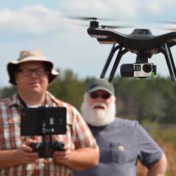
UAS
UAS
An unmanned (or uncrewed) aerial system (UAS) collects digital photos to create digital elevation models. UASs are an increasingly important tool for monitoring, assessing, and conducting targeted scientific research for the nation.
UI
UI
User interface (UI) is the way people interact with a device or software through things like navigation menus, buttons, icons, etc. A good UI is often called "user-friendly."
USGS
USGS
The U.S. Geological Survey (USGS) is the science arm of the Department of the Interior and brings an array of earth, water, biological, and mapping data and expertise to bear in support of decision-making on environmental, resource, and public safety issues.
V
VGI
VGI
Volunteered Geographic Information (VGI) is geospatial content generated by non-professionals using mapping systems available on the Internet including crowdsourcing and Citizen Science.
X
XML
XML
XML (Extensible Markup Language) is a universal way to apply written symbols (also called tags) to written data so that it can be transmitted to other data applications and still be interpreted in the same way.