
Central Plains Water Science Center
Welcome to the U.S. Geological Survey Central Plains Water Science Center. We deliver high-quality, impartial data and scientific research on water resources across Kansas and Nebraska. Our work supports informed decision-making by Federal, State, Tribal, and local partners, helping to ensure public safety, environmental sustainability, and effective water management. Explore our site to access streamflow, groundwater, and water-quality data, as well as our latest research and publications.
Current water conditions in Kansas and Nebraska
Current water conditions in Kansas and Nebraska
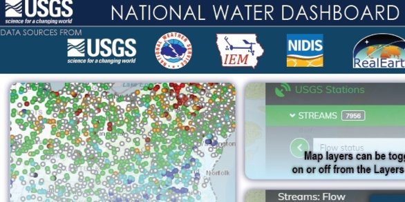
Explore real-time streamflow, groundwater, and water-quality conditions in Kansas and Nebraska and access data through an interactive map.
National Real-Time Water Quality Data
National Real-Time Water Quality Data
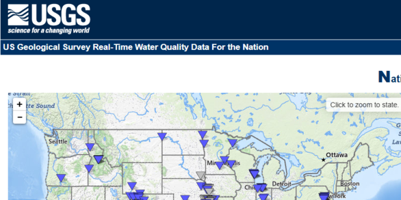
Visualize and access real-time water quality data, including sites in Kansas and Nebraska.
News
Central Plains Water Science Center Quarterly Newsletter - June 2026
Central Plains Water Science Center Quarterly Newsletter - June 2026
The Central Plains Water Science Center Presents: Science Seminar Series - June 2026
The Central Plains Water Science Center Presents: Science Seminar Series - June 2026
Central Plains Water Science Center Quarterly Newsletter - March 2026
Central Plains Water Science Center Quarterly Newsletter - March 2026
Publications
Magnitude and frequency of peak and low flows in the Elkhorn River Basin, Nebraska, 1881–2022 Magnitude and frequency of peak and low flows in the Elkhorn River Basin, Nebraska, 1881–2022
Flood-frequency analysis is based on records of annual maximum instantaneous flows observed at long-term streamgages with 10 years or more of operation. Since the last flood-frequency analysis in Nebraska, an additional 30 years of annual peak-flow data have become available, and new flood-frequency analysis techniques have been developed. Moreover, the Elkhorn River Basin in north...
Scenarios to assess the future water availability in the Mississippi River Valley Alluvial Aquifer for the Cache River and Grand Prairie Regions of Arkansas Scenarios to assess the future water availability in the Mississippi River Valley Alluvial Aquifer for the Cache River and Grand Prairie Regions of Arkansas
The U.S. Geological Survey, as part of the Arkansas Groundwater Initiative, developed forecast scenarios using previously calibrated MODFLOW 6 groundwater models that focused on the Cache and Grand Prairie Critical Groundwater Areas to assess the impact of future climate and water management strategies on the Mississippi River Valley alluvial aquifer. A Soil Water Balance model was used...
Science

Exploring the Link Between Cyanobacteria Blooms and Respiratory Health
Cyanobacterial harmful algal blooms (cyanoHABs) are common in freshwater systems and can produce toxins that pose health risks. A recent study investigated whether these blooms were linked to emergency department visits for asthma or wheeze in Wisconsin communities by combining satellite observations of cyanoHABs with hospital records. The study found no evidence that cyanoHABs caused measurable...
Tracking Toxins at the Coastline: A National Look at Harmful Algal Toxins in U.S. Coastal Waters
This study is a major step forward in understanding how harmful algal blooms, which are often associated with lakes and rivers, can also affect coastal environments. It provides important baseline information for scientists, public health officials, and environmental managers.

Effect of Water-Injection Dredging (WID) Operations on Water Quality Downstream from Tuttle Creek Reservoir
USGS continuous water-quality monitoring and discrete sampling is an integral component for understanding pre-, during, and post-WID water-quality conditions and the impacts on the surrounding ecosystems.


