
Groundwater Monitoring Program for the City of Lawrenceville, Georgia
The city of Lawrenceville, in cooperation with the U.S. Geological Survey, established a hydrologic monitoring network. The network consists of ground water (regolith and bedrock wells) and surface water (streamgages) sites in the two newly developed basins and in a background basin (upper Apalachee River Basin) that is not influenced by the main pumping centers. An additional streamgage was installed in each of the basins and, beginning in 2006, in the Shoal Creek Basin. The data and information collected during the study can be used by local resource managers to develop a sustainable ground-water supply while minimizing the effects on surface-water resources. The data also will help in understanding changes in surface-water quality over time.
Problem:
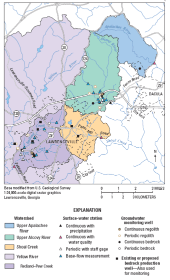
Ground water from wells completed in fractured crystalline rock provides about 6 percent (0.12 million gallons per day) of the water supply to the city of Lawrenceville, Georgia. Additional ground-water withdrawal is planned in the Redland-Pew Creek and Alcovy River Basins. To enable informed decisions, city managers want to be able to quantify the effects (if any) of groundwater pumping on the surface-water resource as development increases. In addition, city managers recognize a need to collect data to help evaluate the effects of natural and human factors on stream-water quality and, thus, evaluate best-management practices.
Objectives:
- Monitor the effect of increased ground-water withdrawal on ground-water levels and streamflow.
- Determine pre- and post-pumping hydrologic budgets of the Redland-Pew Creek Basin.
- Monitor surface-water flow and precipitation at four monitoring sites.
- Monitor surface-water quality at two
Progress and Significant Results, 2006—2007
- Maintained two continuous ground-water-level recorders in the upper Alcovy River Basin, two in the Redland-Pew Creek River Basin, and one in the upper Apalachee River Basin.
- Obtained intermittent water-level measurements at 21 monitoring wells.
- Installed continuous-recording streamgage and water- quality monitoring station for the Shoal Creek Basin.
- Maintained continuous-recording streamgages at the outflow of the upper Alcovy River Basin, the upper Apalachee River Basin, the Redland-Pew Creek Basin, and the Shoal Creek Basin to establish information on base flow, runoff, and other hydrologic properties, including selected water-quality characteristics.
- Maintained and obtained streamflow readings at four additional staff-gage monitoring sites.
- Made low-flow (seepage) measurements during fall 2006 (22) and 2007 (8) low-flow period to quantify the ground-water contribution to streamflow in areas being monitored.
- Completed packer testing of well 14FF55 to investigate elevated uranium levels in water samples collected from specific intervals within the well.
- Updated the project Web site.
Progress and Significant Results, 2004—2005
- Maintained two continuous ground-water-level recorders in the upper Alcovy River Basin, two in the Redland-Pew Creek River Basin, and one in the upper Apalachee River Basin.
- Obtained biweekly water-level measurements at 21 monitoring wells.
- Maintained continuous-recording streamgages at the outflow of both the upper Alcovy River and the Redland-Pew Creek River Basins to establish baseline information on baseflow, runoff, and other hydrologic properties.
- Maintained and obtained streamflow readings at four additional staff-gage monitoring sites.
- Obtained seepage measurements during the fall 2004 low-flow period to quantify the ground-water contribution to streamflow in areas being monitored.
- Maintained a project Web site.
Progress and Significant Results, 2002—2003
- Installed 11 new monitoring wells during July 2003 to form a network of 27 wells to monitor long-term water levels in areas of increased ground-water withdrawal.
- Installed continuous water-level recorders on a well pair in the upper Alcovy River Basin, on a well pair in the Redland- Pew Creek River Basin, and on a single well in the upper Apalachee River Basin.
- Obtained weekly water-level measurements at 21 monitoring wells.
- Installed continuous-recording streamgages at the outflow of both the upper Alcovy River and the Redland-Pew Creek River Basins.
- Installed staff gages at four additional streamflow monitoring sites.
- Obtained weekly staff-gage readings and streamflow measurements at the four periodic streamflow measurement sites.
- Obtained seepage measurements during the low-flow period in the fall of 2003 to quantify the ground-water contribution to streamflow in areas to be pumped.
- Developed a project internet site.
Related Documents
- Groundwater Conditions and Studies in Georgia, 2008–2009, pg 70-71
- Ground-Water Conditions and Studies in Georgia, 2006 –2007, pg 80-81
- Ground-Water Conditions and Studies in Georgia, 2004 –2005, pg 78-79
- Ground-Water Conditions and Studies in Georgia, 2002– 03, pg. 80-81
- Ground-Water Conditions and Studies in Georgia, 2001, pg. 78-81
- Naturally occurring radionuclides in Georgia water supplies: implications for community water systems
- Influence of foliation fracture systems on water availability in the Lawrenceville, Georgia, area
The city of Lawrenceville, in cooperation with the U.S. Geological Survey, established a hydrologic monitoring network. The network consists of ground water (regolith and bedrock wells) and surface water (streamgages) sites in the two newly developed basins and in a background basin (upper Apalachee River Basin) that is not influenced by the main pumping centers. An additional streamgage was installed in each of the basins and, beginning in 2006, in the Shoal Creek Basin. The data and information collected during the study can be used by local resource managers to develop a sustainable ground-water supply while minimizing the effects on surface-water resources. The data also will help in understanding changes in surface-water quality over time.
Problem:
Ground water from wells completed in fractured crystalline rock provides about 6 percent (0.12 million gallons per day) of the water supply to the city of Lawrenceville, Georgia. Additional ground-water withdrawal is planned in the Redland-Pew Creek and Alcovy River Basins. To enable informed decisions, city managers want to be able to quantify the effects (if any) of groundwater pumping on the surface-water resource as development increases. In addition, city managers recognize a need to collect data to help evaluate the effects of natural and human factors on stream-water quality and, thus, evaluate best-management practices.
Objectives:
- Monitor the effect of increased ground-water withdrawal on ground-water levels and streamflow.
- Determine pre- and post-pumping hydrologic budgets of the Redland-Pew Creek Basin.
- Monitor surface-water flow and precipitation at four monitoring sites.
- Monitor surface-water quality at two
Progress and Significant Results, 2006—2007
- Maintained two continuous ground-water-level recorders in the upper Alcovy River Basin, two in the Redland-Pew Creek River Basin, and one in the upper Apalachee River Basin.
- Obtained intermittent water-level measurements at 21 monitoring wells.
- Installed continuous-recording streamgage and water- quality monitoring station for the Shoal Creek Basin.
- Maintained continuous-recording streamgages at the outflow of the upper Alcovy River Basin, the upper Apalachee River Basin, the Redland-Pew Creek Basin, and the Shoal Creek Basin to establish information on base flow, runoff, and other hydrologic properties, including selected water-quality characteristics.
- Maintained and obtained streamflow readings at four additional staff-gage monitoring sites.
- Made low-flow (seepage) measurements during fall 2006 (22) and 2007 (8) low-flow period to quantify the ground-water contribution to streamflow in areas being monitored.
- Completed packer testing of well 14FF55 to investigate elevated uranium levels in water samples collected from specific intervals within the well.
- Updated the project Web site.
Progress and Significant Results, 2004—2005
- Maintained two continuous ground-water-level recorders in the upper Alcovy River Basin, two in the Redland-Pew Creek River Basin, and one in the upper Apalachee River Basin.
- Obtained biweekly water-level measurements at 21 monitoring wells.
- Maintained continuous-recording streamgages at the outflow of both the upper Alcovy River and the Redland-Pew Creek River Basins to establish baseline information on baseflow, runoff, and other hydrologic properties.
- Maintained and obtained streamflow readings at four additional staff-gage monitoring sites.
- Obtained seepage measurements during the fall 2004 low-flow period to quantify the ground-water contribution to streamflow in areas being monitored.
- Maintained a project Web site.
Progress and Significant Results, 2002—2003
- Installed 11 new monitoring wells during July 2003 to form a network of 27 wells to monitor long-term water levels in areas of increased ground-water withdrawal.
- Installed continuous water-level recorders on a well pair in the upper Alcovy River Basin, on a well pair in the Redland- Pew Creek River Basin, and on a single well in the upper Apalachee River Basin.
- Obtained weekly water-level measurements at 21 monitoring wells.
- Installed continuous-recording streamgages at the outflow of both the upper Alcovy River and the Redland-Pew Creek River Basins.
- Installed staff gages at four additional streamflow monitoring sites.
- Obtained weekly staff-gage readings and streamflow measurements at the four periodic streamflow measurement sites.
- Obtained seepage measurements during the low-flow period in the fall of 2003 to quantify the ground-water contribution to streamflow in areas to be pumped.
- Developed a project internet site.
Related Documents
- Groundwater Conditions and Studies in Georgia, 2008–2009, pg 70-71
- Ground-Water Conditions and Studies in Georgia, 2006 –2007, pg 80-81
- Ground-Water Conditions and Studies in Georgia, 2004 –2005, pg 78-79
- Ground-Water Conditions and Studies in Georgia, 2002– 03, pg. 80-81
- Ground-Water Conditions and Studies in Georgia, 2001, pg. 78-81
- Naturally occurring radionuclides in Georgia water supplies: implications for community water systems
- Influence of foliation fracture systems on water availability in the Lawrenceville, Georgia, area