
Sand Hollow Reservoir in Washington County, Utah, was completed in March 2002 and is operated for both surface-water storage and managed aquifer recharge via infiltration from surface basin spreading to the underlying Navajo Sandstone. From 2002 through 2014, about 216,000 acre-feet were diverted from the Virgin River to Sand Hollow Reservoir, and about 127,000 acre-feet of water seeped beneath the reservoir to recharge the underlying Navajo Sandstone aquifer. Groundwater levels in monitoring wells near the reservoir rose through 2006 but have fluctuated more recently because of variations in reservoir stage and nearby pumping from production wells.
In 2002, managed aquifer recharge rates were initially very high (1.5 x 10⁻⁴ cm/s) with the vadose zone becoming saturated beneath and surrounding the reservoir. During 2008, these rates declined to less than 3.5 x 10⁻⁶ cm/s. This decrease was likely associated with a declining regional hydraulic gradient and clogging. From mid-2009 through 2010, recharge rates increased. This change may have been partly caused by dissolution of air bubbles initially entrapped in the aquifer matrix. Theoretical gas dissolution rates, coupled with field evidence of a decline in total dissolved-gas pressure and dissolved oxygen from nearby monitoring wells, support the timing of this gas dissipation.
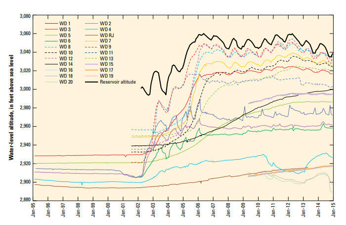
Water quality continued to be monitored at various wells in Sand Hollow from 2013 through 2014 to evaluate the timing and location of reservoir recharge as it moved through the aquifer. Changing geochemical conditions at monitoring wells WD 4 and WD 12 indicated rising groundwater levels and mobilization of vadose-zone salts, which could be a precursor to the arrival of reservoir recharge.

Between 2004 and 2014, about 29,000 acre-feet of groundwater was withdrawn from nearby wells for municipal supply. In addition, about 31,000 acre-feet of shallow seepage was captured by french drains adjacent to the North and West Dams and used for municipal supply, irrigation, or returned to the reservoir.
Sand Hollow Reservoir in Washington County, Utah, was completed in March 2002 and is operated for both surface-water storage and managed aquifer recharge via infiltration from surface basin spreading to the underlying Navajo Sandstone. From 2002 through 2014, about 216,000 acre-feet were diverted from the Virgin River to Sand Hollow Reservoir, and about 127,000 acre-feet of water seeped beneath the reservoir to recharge the underlying Navajo Sandstone aquifer. Groundwater levels in monitoring wells near the reservoir rose through 2006 but have fluctuated more recently because of variations in reservoir stage and nearby pumping from production wells.
In 2002, managed aquifer recharge rates were initially very high (1.5 x 10⁻⁴ cm/s) with the vadose zone becoming saturated beneath and surrounding the reservoir. During 2008, these rates declined to less than 3.5 x 10⁻⁶ cm/s. This decrease was likely associated with a declining regional hydraulic gradient and clogging. From mid-2009 through 2010, recharge rates increased. This change may have been partly caused by dissolution of air bubbles initially entrapped in the aquifer matrix. Theoretical gas dissolution rates, coupled with field evidence of a decline in total dissolved-gas pressure and dissolved oxygen from nearby monitoring wells, support the timing of this gas dissipation.
Water quality continued to be monitored at various wells in Sand Hollow from 2013 through 2014 to evaluate the timing and location of reservoir recharge as it moved through the aquifer. Changing geochemical conditions at monitoring wells WD 4 and WD 12 indicated rising groundwater levels and mobilization of vadose-zone salts, which could be a precursor to the arrival of reservoir recharge.
Between 2004 and 2014, about 29,000 acre-feet of groundwater was withdrawn from nearby wells for municipal supply. In addition, about 31,000 acre-feet of shallow seepage was captured by french drains adjacent to the North and West Dams and used for municipal supply, irrigation, or returned to the reservoir.