
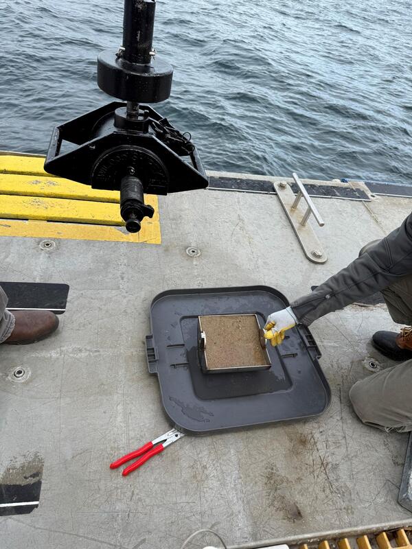
Shipek grab sampler and sediment sample. Image is included in USGS data release, "Grain-size analysis of sediment samples collected in the nearshore zone offshore of Marconi Beach, Wellfleet, MA, December 9, 2024."
Multimedia
Multimedia products produced by Woods Hole Coastal and Marine Science Center staff
Images
Grain-size analysis
Shipek grab sampler and sediment sample. Image is included in USGS data release, "Grain-size analysis of sediment samples collected in the nearshore zone offshore of Marconi Beach, Wellfleet, MA, December 9, 2024."
Social Media: Sediment Movement in Cape Cod Bay
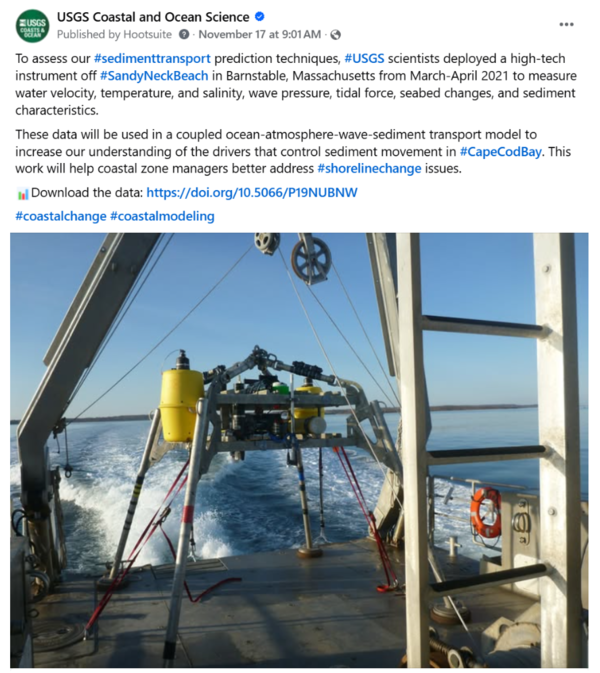
To assess our #sedimenttransport prediction techniques, #USGS scientists deployed a high-tech instrument off #SandyNeckBeach in Barnstable, Massachusetts from March-April 2021 to measure water velocity, temperature, and salinity, wave pressure, tidal force, seabed changes, and sediment characteristics.
To assess our #sedimenttransport prediction techniques, #USGS scientists deployed a high-tech instrument off #SandyNeckBeach in Barnstable, Massachusetts from March-April 2021 to measure water velocity, temperature, and salinity, wave pressure, tidal force, seabed changes, and sediment characteristics.
Marconi Beach CoastCam Maintenance
The USGS uses a nationwide network of coastal observing cameras (CoastCams) to monitor coastal conditions in near real-time and support research on a variety of coastal processes and hazards.
The USGS uses a nationwide network of coastal observing cameras (CoastCams) to monitor coastal conditions in near real-time and support research on a variety of coastal processes and hazards.
Social Media: Biogeomorphic salt marsh model
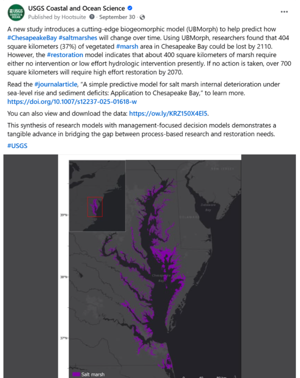
A new study introduces a cutting-edge biogeomorphic model (UBMorph) to help predict how #ChesapeakeBay #saltmarshes will change over time. Using UBMorph, researchers found that 404 square kilometers (37%) of vegetated #marsh area in Chesapeake Bay could be lost by 2110.
A new study introduces a cutting-edge biogeomorphic model (UBMorph) to help predict how #ChesapeakeBay #saltmarshes will change over time. Using UBMorph, researchers found that 404 square kilometers (37%) of vegetated #marsh area in Chesapeake Bay could be lost by 2110.
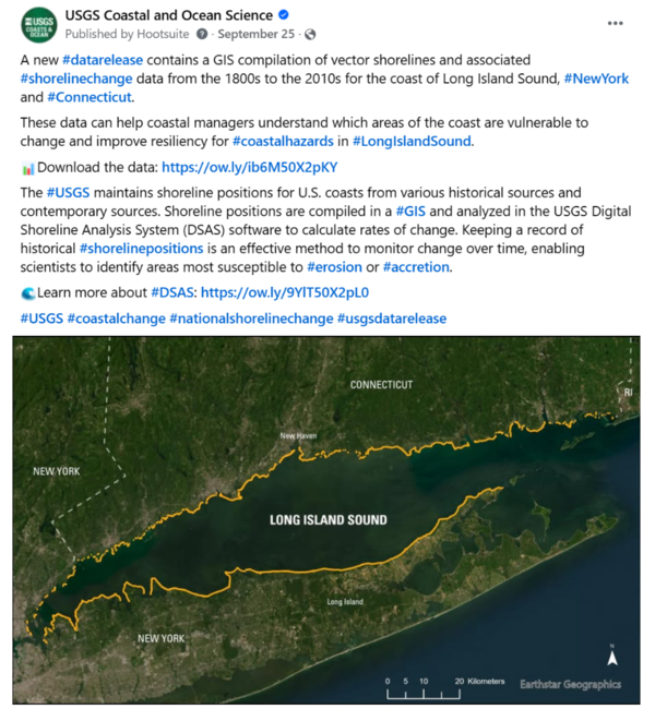
Social Media: Shoreline Change of Long Island Sound
Social Media: Shoreline Change of Long Island SoundA new #datarelease contains a GIS compilation of vector shorelines and associated #shorelinechange data from the 1800s to the 2010s for the coast of Long Island Sound, #NewYork and #Connecticut.
Social Media: Shoreline Change of Long Island Sound
Social Media: Shoreline Change of Long Island SoundA new #datarelease contains a GIS compilation of vector shorelines and associated #shorelinechange data from the 1800s to the 2010s for the coast of Long Island Sound, #NewYork and #Connecticut.
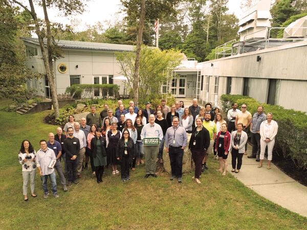
Special Visitors at WHCMSC
Woods Hole Coastal and Marine Science Center staff with Dave Applegate (USGS Chief Scientist and Acting Associate Director, USGS Natural Hazards Mission Area), Jonathan Godt (Program Coordinator, USGS Landslide Hazards Program), and Emily Himmelstoss (Associate Program Coordinator for Science, USGS Coastal and Marine Hazards and Resources Program) during a special v
Woods Hole Coastal and Marine Science Center staff with Dave Applegate (USGS Chief Scientist and Acting Associate Director, USGS Natural Hazards Mission Area), Jonathan Godt (Program Coordinator, USGS Landslide Hazards Program), and Emily Himmelstoss (Associate Program Coordinator for Science, USGS Coastal and Marine Hazards and Resources Program) during a special v
Videos

USGS Coastal and Marine Field Operations
To conduct the science needed to understand coastal and marine geohazards, support habitat and resource management, and monitor how these environments change over time, the USGS Coastal and Marine Hazards and Resources Program relies on engineering, mechanical, and electronics expertise for field operations along the coast, in the nearshore environment, and in the d
To conduct the science needed to understand coastal and marine geohazards, support habitat and resource management, and monitor how these environments change over time, the USGS Coastal and Marine Hazards and Resources Program relies on engineering, mechanical, and electronics expertise for field operations along the coast, in the nearshore environment, and in the d

The USGS Northeast Region: Delivering Science for Better Decisions
The USGS Northeast Region: Delivering Science for Better DecisionsThis video is an introduction of the USGS Northeast Region's science efforts to support society's evolving needs through its engaged and skilled workforce.
The USGS Northeast Region: Delivering Science for Better Decisions
The USGS Northeast Region: Delivering Science for Better DecisionsThis video is an introduction of the USGS Northeast Region's science efforts to support society's evolving needs through its engaged and skilled workforce.

Introduction to the USGS Coastal Science Navigator
Introduction to the USGS Coastal Science NavigatorThe Coastal Science Navigator is intended to help users discover USGS Coastal Change Hazards information, products, and tools relevant to their scientific or decision-making needs.
Introduction to the USGS Coastal Science Navigator
Introduction to the USGS Coastal Science NavigatorThe Coastal Science Navigator is intended to help users discover USGS Coastal Change Hazards information, products, and tools relevant to their scientific or decision-making needs.

Flyover of the U.S. Coastline
Our Nation’s coastlines are almost 100,000 miles long. These extensive coastal areas stretch from Maine’s Atlantic shores in the northeast, south along the shores of the Gulf of Mexico and insular areas in the Caribbean.
Our Nation’s coastlines are almost 100,000 miles long. These extensive coastal areas stretch from Maine’s Atlantic shores in the northeast, south along the shores of the Gulf of Mexico and insular areas in the Caribbean.

Assateague Island National Seashore
sUAS coastal Imagery collected by the Woods Hole Coastal and Marine Science Center Aerial Imaging and Mapping group (AIM) at Assateague Island National Seashore October 10-14th, 2022.
sUAS coastal Imagery collected by the Woods Hole Coastal and Marine Science Center Aerial Imaging and Mapping group (AIM) at Assateague Island National Seashore October 10-14th, 2022.
Webcams

Marconi Beach video camera 1 dark image
Two video cameras are mounted on a bluff above Marconi Beach, Cape Cod National Seashore, Wellfleet, MA. Every half hour, the video cameras collect imagery for 10 minutes. This is the “dark” image, the darkest pixel values throughout the video, useful for tracking sediment plumes, tracking floating debris, and filtering out breaking waves.
Two video cameras are mounted on a bluff above Marconi Beach, Cape Cod National Seashore, Wellfleet, MA. Every half hour, the video cameras collect imagery for 10 minutes. This is the “dark” image, the darkest pixel values throughout the video, useful for tracking sediment plumes, tracking floating debris, and filtering out breaking waves.

Marconi Beach video camera 1 variance image
Two video cameras are mounted on a bluff above Marconi Beach, Cape Cod National Seashore, Wellfleet, MA. Every half hour, the video cameras collect imagery for 10 minutes.
Two video cameras are mounted on a bluff above Marconi Beach, Cape Cod National Seashore, Wellfleet, MA. Every half hour, the video cameras collect imagery for 10 minutes.

Marconi Beach video camera 2 dark image
Two video cameras are mounted on a bluff above Marconi Beach, Cape Cod National Seashore, Wellfleet, MA. Every half hour, the video cameras collect imagery for 10 minutes. This is the “dark” image, the darkest pixel values throughout the video, useful for tracking sediment plumes, tracking floating debris, and filtering out breaking waves.
Two video cameras are mounted on a bluff above Marconi Beach, Cape Cod National Seashore, Wellfleet, MA. Every half hour, the video cameras collect imagery for 10 minutes. This is the “dark” image, the darkest pixel values throughout the video, useful for tracking sediment plumes, tracking floating debris, and filtering out breaking waves.

Marconi Beach video camera 2 variance image
Two video cameras are mounted on a bluff above Marconi Beach, Cape Cod National Seashore, Wellfleet, MA. Every half hour, the video cameras collect imagery for 10 minutes.
Two video cameras are mounted on a bluff above Marconi Beach, Cape Cod National Seashore, Wellfleet, MA. Every half hour, the video cameras collect imagery for 10 minutes.

Marconi Beach video camera 1 bright image
Two video cameras are mounted on a bluff above Marconi Beach, Cape Cod National Seashore, Wellfleet, MA. Every half hour, the video cameras collect imagery for 10 minutes.
Two video cameras are mounted on a bluff above Marconi Beach, Cape Cod National Seashore, Wellfleet, MA. Every half hour, the video cameras collect imagery for 10 minutes.
Marconi Beach video camera 1 timex image
Two video cameras are mounted on a bluff above Marconi Beach, Cape Cod National Seashore, Wellfleet, MA. Every half hour, the video cameras collect imagery for 10 minutes.
Two video cameras are mounted on a bluff above Marconi Beach, Cape Cod National Seashore, Wellfleet, MA. Every half hour, the video cameras collect imagery for 10 minutes.