
We monitor hydrologic conditions so you can make informed decisions
Our Scientists operate state-of-the-art data networks that provide spatially-consistent data to compare to historic trends
Our Scientists operate state-of-the-art data networks that provide spatially-consistent data to compare to historic trends
We investigate and study our world and its relation to water
NJWSC is highly involved in research into our ecosystems, streams, groundwater, and their health and water quality
NJWSC is highly involved in research into our ecosystems, streams, groundwater, and their health and water quality
USGS National Water Dashboard for New Jersey
USGS Real-Time Water Data Mapper highlighting New Jersey
USGS Real-Time Water Data Mapper highlighting New Jersey
Coastal Floodplain Inundation Map
New Jersey Long-term Water Monitoring Networks
Learn about our Long-term Water Monitoring Networks
Learn about our Long-term Water Monitoring Networks
PFAS in Surface Waters of the Non-Tidal Passaic River Basin
North Jersey PFAS
North Jersey PFAS
New Jersey Water Science Center
Welcome! Since 1903, the New Jersey Water Science Center has been collecting high-quality hydrologic data and conducting unbiased water-science research to address the water-resource priorities of the Nation, global trends and support statewide water-resource infrastructure and management needs.
New Jersey Current Water Conditions
New Jersey Current Water Conditions

Real-time New Jersey Streamflow, Groundwater, and Water-quality conditions available through the National Water Data Dashboard interactive map application.

NJ WSC Quick Links
NJ WSC Quick Links
Explore some of our more popular science and tools
News
The Jersey Current: Spring/Summer 2026 - Vol. 1 | Issue 1
The Jersey Current: Spring/Summer 2026 - Vol. 1 | Issue 1
Geospatial Applications to Visualize Science and Support Decision‑Making Across Scales
Geospatial Applications to Visualize Science and Support Decision‑Making Across Scales
Predictions of PFAS in groundwater at drinking water supply depths in the U.S.
Predictions of PFAS in groundwater at drinking water supply depths in the U.S.
Publications
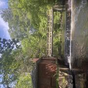
Analysis of alternative weir designs for improved passage of select fish at the U.S. Geological Survey streamgaging weir at Blackwells Mills, New Jersey Analysis of alternative weir designs for improved passage of select fish at the U.S. Geological Survey streamgaging weir at Blackwells Mills, New Jersey
As the population of New Jersey continues to remain dense, the need for water supply will likely continue to be high, which can lead to water managers needing to make difficult decisions about managing drinking-water supply. Streamgaging weirs like the ones used by the U.S. Geological Survey (USGS) play a critical role in providing accurate and stable streamflow data, but their presence...
Understanding the occurrence and distribution of per- and polyfluoroalkyl substances (PFAS) in surface waters of the nontidal Passaic River Basin Understanding the occurrence and distribution of per- and polyfluoroalkyl substances (PFAS) in surface waters of the nontidal Passaic River Basin
This study, completed by the U.S. Geological Survey in cooperation with the North Jersey District Water Supply Commission (NJDWSC), was designed to characterize the occurrence and distribution of per- and polyfluoroalkyl substances (PFAS) in surface waters of the nontidal Passaic River Basin in New Jersey that have the potential to affect public-drinking-water quality. In 2025, 37 sites...
Occurrence of cyanobacteria and associated cyanotoxins in the Raritan Basin Water Supply Complex, New Jersey, August 2020 to August 2021 Occurrence of cyanobacteria and associated cyanotoxins in the Raritan Basin Water Supply Complex, New Jersey, August 2020 to August 2021
Harmful algal blooms, particularly cyanobacteria harmful algal blooms (cyanoHABs), have emerged as a substantial global concern because of their detrimental effects on water quality and aquatic ecosystem health. CyanoHABs can produce cyanotoxins, which pose serious health risks to humans and wildlife, such as liver failure and respiratory distress. This is particularly concerning for...
Science
New Jersey ScienceBase Catalog
Hydrologic data collection, processing, analysis, dissemination, and archiving are major parts of the New Jersey Water Science Center program. ScienceBase is a primary repository for USGS data releases, published USGS scientific data and metadata, presented in a structured, discoverable format.

Coastal Plain Chloride Network
Chloride levels in groundwater are measured in selected wells on a 5‑year cycle to provide early warning of saltwater intrusion and to delineate the 250 mg/L line of equal chloride concentration within the principal aquifers of the New Jersey Coastal Plain.

Manning's Roughness Coefficient for New Jersey Streams
Manning’s Roughness Coefficient ( n) is an input to the Manning’s Equation, which can be used for the computation of streamflow during times it is impractical or impossible to make a measurement. Methods and regional equations for determining the value of n have largely been developed in the western United States; New Jersey is comparatively unstudied. New Jersey features a diverse range of...