
Low Flow Site Map for Georgia, North and South Carolina
By South Atlantic Water Science Center (SAWSC)
September 2022 (approx.)

Detailed Description
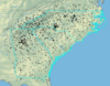
Low Flow Regionalization Study Site Map for Georgia, North Carolina and South Carolina
Sources/Usage
Public Domain.
Related

Computation of low-flow statistics at continuous-record streamgages and regionalization of selected low-flow characteristics for streams in Georgia, South Carolina, and North Carolina
This ongoing USGS study for Georgia, South Carolina, and North Carolina aims to (1) compute low-flow statistics at selected continuous-record streamgages in Georgia, South Carolina, and North Carolina and to (2) develop regional regression equations for a subset of those low-flow characteristics for streams that are not substantially affected by tides, regulation, diversions, or other...
Related
Computation of low-flow statistics at continuous-record streamgages and regionalization of selected low-flow characteristics for streams in Georgia, South Carolina, and North Carolina
This ongoing USGS study for Georgia, South Carolina, and North Carolina aims to (1) compute low-flow statistics at selected continuous-record streamgages in Georgia, South Carolina, and North Carolina and to (2) develop regional regression equations for a subset of those low-flow characteristics for streams that are not substantially affected by tides, regulation, diversions, or other...