
StreamStats Delineation Density
By StreamStats

Detailed Description
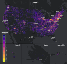
StreamStats Delineations - Where are they?
This figure shows the density of delineations per 25 square kilometer grid for all delineations over the period 3/16/24-3/15/25. Patterns in the delineation points show a significant use in areas near cities and along transportation corridors. The median basin delineated in StreamStats over the last year is 2 square miles and number of delineations totaled 605,106.
Sources/Usage
Public Domain.