
Media Alert: Low-level airplane flights to scan geology over parts of four Midwestern states
The USGS and the state geological surveys of Missouri, Illinois, Iowa, and Wisconsin will map critical minerals starting in November
RESTON, Va. — The U.S. Geological Survey plans low-level airplane flights over a broad region in Missouri, Illinois, Iowa, and Wisconsin to image geology using airborne geophysical technology. The survey will begin this month and take approximately a year to complete, weather and wildfire restrictions permitting.
The flights are a collaborative effort between the USGS Earth Mapping Resources Initiative and the geological surveys of Illinois, Iowa, Missouri, and Wisconsin, and are part of a national effort to map critical mineral resources and modernize mapping of the nation’s geology.
“Earth MRI is mapping the critical minerals needed to drive the U.S. economy and bolster national security. Partnering with the state geological surveys of Illinois, Iowa, Missouri, and Wisconsin helps with the work of the nation -- and adds to state knowledge crucial to the resource economy, as well as water resources, and natural hazards,” said Jamey Jones, science coordinator for the U.S. Geological Survey’s Earth MRI.
“Earth MRI has been vital to the Iowa Geological Survey’s efforts to better understand the critical mineral potential of Iowa and surrounding areas,” said Ryan Clark, associate Iowa state geologist for energy and minerals. “The planned survey along the Upper Mississippi Valley will provide key information that will support ongoing research in the region focused on buried bedrock formations that are prospective for critical minerals such as rare earth elements.”
Potential minerals in the region include barite, cobalt, gallium, germanium, indium, rare earth elements and zinc, all of which are on the List of Critical Minerals maintained by the USGS as essential for the U.S. economy and national security, with a risk of supply chain disruption. Gallium, germanium and rare earth elements are all used in advanced technology and defense, and China has restricted exports of each to the United States.
The survey will provide images that facilitate geologic mapping of mineral resource potential within the Upper Mississippi Valley Mineral District where lead-zinc deposits also contain gallium, germanium, and indium. The survey will also cover the western edge of the Illinois Basin.
The USGS has contracted with Fugro and Xcalibur Smart Mapping to collect the airborne data. Their small fixed-wing aircraft will be equipped with either an elongated “stinger” that houses sensors to collect data and extends behind the main cabin, or wing tip sensors. These scientific instruments are completely passive with no emissions that pose a risk to humans, animals, or plant life. No photography or video data will be collected. The aircraft will be flown by experienced pilots who are specially trained and approved for low-level flying. These pilots work with the FAA to ensure flights are safe and in accordance with U.S. law. The surveys will be conducted during daylight hours only.

The flights will be based out of Dubuque Regional (KDBQ), Mount Pleasant Municipal (KMPZ), Pittsfield Penstone Municipal (KPPQ), and Marshall Memorial Municipal (KMHL) airports. The flights could shift with little warning to other parts of the survey area as necessitated by flying conditions.
The survey fits into a broader effort by the USGS, the state geological surveys of Illinois, Iowa, Missouri and Wisconsin, and other partners—including private companies, academics and state and federal agencies—to modernize understanding of the nation’s fundamental geologic framework and mineral resources.
This effort is known as the Earth Mapping Resources Initiative, and it includes airborne geophysical surveys like this one, geochemical reconnaissance surveys, topographic mapping using LiDAR technology, hyperspectral surveys, and geologic mapping projects.
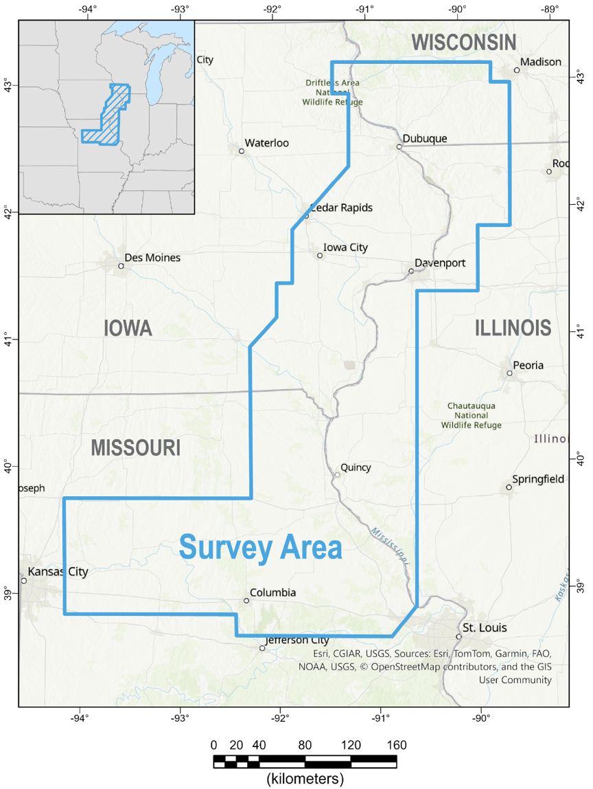
Map showing the location of the survey over Missouri, Illinois, Iowa, and Wisconsin. Flights will cover areas within the Missouri counties of Montgomery, Saline, Audrain, Shelby, Warren, Ray, Pettis, Scotland, Cole, Osage, Cooper, Linn, Moniteau, Monroe, Jackson, Chariton, Macon, Franklin, Howard, Knox, Livingston, Randolph, Caldwell, Clark, St. Charles, Lewis, Carroll, Lincoln, Boone, Ralls, Marion, Johnson, Callaway, Gasconade, Lafayette, and Pike; Illinois counties of Hancock, Ogle, Morgan, Brown, Warren, Henderson, Stephenson, Cass, Scott, Mercer, Jo Daviess, Greene, Rock Island, Carroll, McDonough, Whiteside, Schuyler, Pike, Adams, Calhoun, Lee, and Henry; Iowa counties of Delaware, Jefferson, Washington, Henry, Louisa, Dubuque, Linn, Davis, Wapello, Cedar, Clayton, Jones, Johnson, Clinton, Des Moines, Allamakee, Van Buren, Lee, Muscatine, Scott, Keokuk, and Jackson; and Wisconsin counties of Dane, Iowa, Grant, Green, Sauk, Crawford, and Lafayette.