
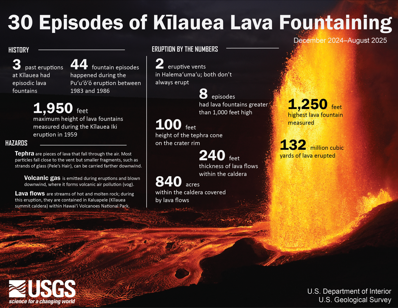
Photo & Video Chronology — August 6, 2025 — Episode 30 at Kīlauea summit
By Hawaiian Volcano Observatory
August 6, 2025
Episode 30 of the ongoing Halemaʻumaʻu eruption began at approximately 1:20 a.m. HST on August 6, 2025
Media
Sources/Usage: Public Domain. View Media Details
Media
Sources/Usage: Public Domain. View Media Details
Media
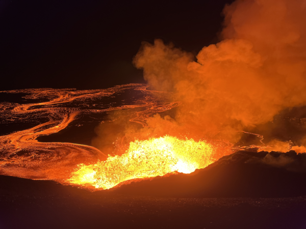
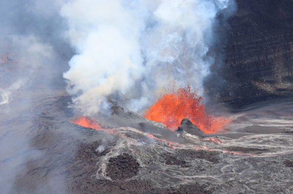
Early in the morning on August 6, Hawaiian Volcano Observatory geologists visited the western rim of Halemaʻumaʻu crater to observe Kīlauea summit eruption episode 30. Lava fountains were reaching about 70 meters (230 feet) above the north vent at the time. USGS photo by N. Deligne.
Sources/Usage: Public Domain. View Media Details
Media
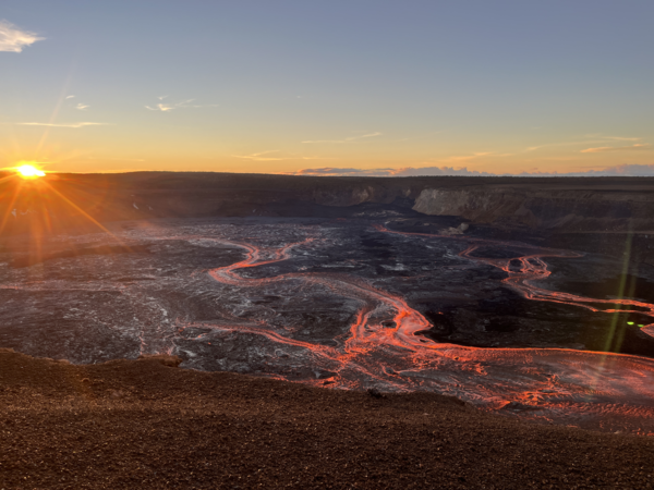
Hawaiian Volcano Observatory geologists watched a spectacular sunrise over Kīlauea summit eruption episode 30 on the morning of August 6. Lava flows had covered about 60% of the Halemaʻumaʻu crater floor by that time. USGS photo by N. Deligne.
Sources/Usage: Public Domain. View Media Details
Media
A helicopter overflight on the morning of August 6, during episode 30 of the ongoing Halema‘uma‘u eruption, provided aerial views of the lava fountaining and numerous channelized lava flows covering the crater floor. USGS photo by M. Patrick.
Sources/Usage: Public Domain. View Media Details
Media
An aerial photograph of the ongoing Kīlauea summit eruption within Halema‘uma‘u crater taken during an overflight on August 6, 2025. This photo, looking to the west, shows episode 30 lava fountains and lava flows covering the crater floor. A thick plume of volcanic gas and water vapor is seen rising from the vent and being blown to the southeast during normal trade wind conditions. USGS photo by M. Bagnardi.
Sources/Usage: Public Domain. View Media Details
Media
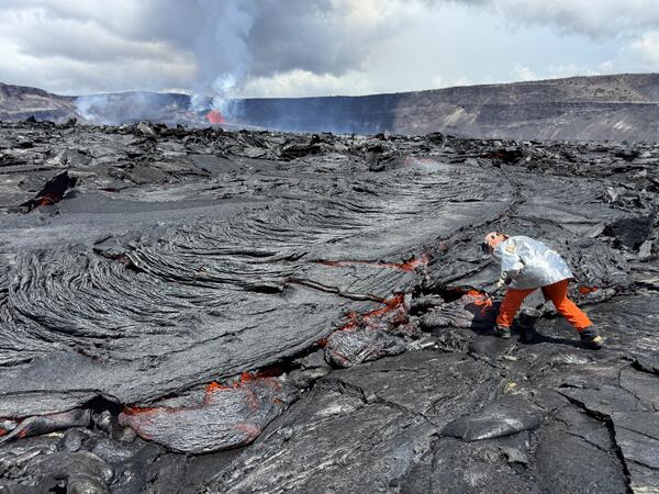
A USGS geologist collects a molten sample of the episode 30 lava flows, quenching the sample in a bucket of water. The chemistry of these lava samples is analyzed to better understand the source and storage of magma driving Hawaiian eruptions. USGS photo by M. Patrick taken on August 6, 2025.
Sources/Usage: Public Domain. View Media Details
Media
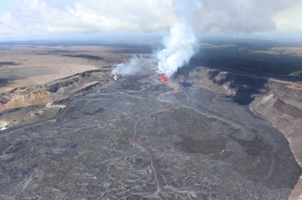
A telephoto aerial view of the episode 30 lava fountaining at Kīlauea summit, taken during a morning helicopter overflight. The dominant fountain was in the north vent, while a smaller fountain was active in the south vent. Channelized streams of lava, fed by the fountains in the north and south vents, flow to the eastern portion of the crater floor. USGS photo taken by M. Bagnardi on August 6, 2025.
Sources/Usage: Public Domain. View Media Details
Media
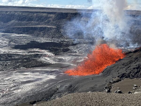
A view of the episode 30 lava fountaining in the north vent, taken from the west rim of Kaluapele, Kīlauea's summit caldera. The fountaining was sending out several lava channels across the crater floor, with lava flows reaching the eastern portion of Halema‘uma‘u crater. USGS photo taken by M. Patrick on August 6, 2025.
Sources/Usage: Public Domain. View Media Details
Media
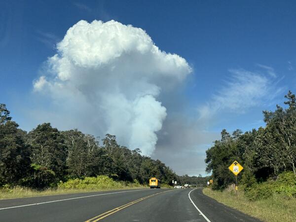
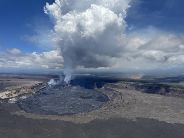
Slack winds allowed the outgassing plume from the episode 30 lava fountaining to rise vertically above Kīlauea summit caldera, making it easily visible from Highway 11. USGS photo by M. Patrick.
Sources/Usage: Public Domain. View Media Details
Media
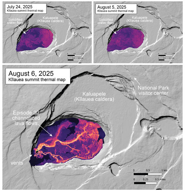
The August 6 thermal map shows the widespread channelized lava flows covering the crater floor, originating from the episode 30 lava fountaining in the western end of Halema‘uma‘u crater at the summit of Kīlauea. Most of the lava originated from the vigorous fountaining at the north vent, with the weak fountaining at the south vent contributing a smaller volume. Also shown are two thermal maps collected during the quiet interval between lava fountaining episodes, when the crater floor consists of solidified, inactive lava.
Sources/Usage: Public Domain. View Media Details
Media
Sources/Usage: Public Domain. View Media Details