
USGS-NNSS Regional Groundwater Explorer
July 28, 2025
Media
Sources/Usage: Public Domain. View Media Details
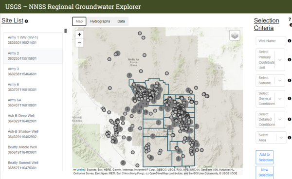
The USGS-NNSS Regional Groundwater Explorer is a web-based application developed by the USGS, in cooperation with DOE. The application provides access to a comprehensive database of groundwater levels, hydrologic conditions, construction, and descriptive narratives for wells on and adjacent to the NNSS. The Groundwater Explorer is designed to be a user-friendly and interactive application for data exploration and retrieval. The application contains interactive network maps, additive filters to narrow searches, and hydrographs with comparative tools. Detailed reports can be generated for all wells of interest, and their associated data tables can be exported for use outside of the web-based application.
Related

U.S. Geological Survey-U.S. Department of Energy Cooperative Studies
The U.S. Geological Survey (USGS) provides hydrologic, scientific, and technical expertise to the U.S. Department of Energy (DOE) to address environmental and scientific issues at the Nevada National Security Sites (NNSS) and surrounding area. The NNSS, in Nye County, Nevada, was the site of historical nuclear testing. An overview of selected USGS program efforts in cooperation with DOE are...
Related
U.S. Geological Survey-U.S. Department of Energy Cooperative Studies
The U.S. Geological Survey (USGS) provides hydrologic, scientific, and technical expertise to the U.S. Department of Energy (DOE) to address environmental and scientific issues at the Nevada National Security Sites (NNSS) and surrounding area. The NNSS, in Nye County, Nevada, was the site of historical nuclear testing. An overview of selected USGS program efforts in cooperation with DOE are...