
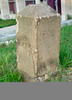
A boundary stone in SE DC
By Volcano Hazards Program
1905 (approx.)

Detailed Description
Southeast No. 6 Boundary Marker of the Original District of Columbia on the NRHP since November 1, 1996. At 901 Southern Ave., Washington, D.C. Also in Prince George's County, Maryland. This stone is one of the best preserved and accessible of the original 40 stones. This one reads SW face "Jurisdiction of the United States Miles 6" and SE face "1792" - photo from wikimedia commons