
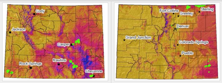
A map of wind power classes for Wyoming and Colorado.

Detailed Description
Orange to purple areas represent poor to superb wind power potential, respectively. Green patches represent known wind turbine locations. (source: National Renewable Energy Laboratory; USGS images). Figure 2 (left): Wind power classes for 50 meters above-ground elevation in Wyoming (777 turbines). Figure 3 (right): Wind power classes for 50 meters above-ground elevation in Colorado (910 turbines).
Sources/Usage
Related

Resources for Understanding the Effects of Wind Energy Development
As the Nation strives to lessen its dependence on foreign oil, domestic energy production has increased dramatically. This is especially true for renewable energy sources such as wind: from 2007 to 2009, for example, wind energy development increased 341 percent in Wyoming, and it continues on that trajectory today. However, the effects of renewable energy development on wildlife and habitats...
Related
Resources for Understanding the Effects of Wind Energy Development
As the Nation strives to lessen its dependence on foreign oil, domestic energy production has increased dramatically. This is especially true for renewable energy sources such as wind: from 2007 to 2009, for example, wind energy development increased 341 percent in Wyoming, and it continues on that trajectory today. However, the effects of renewable energy development on wildlife and habitats...