
A photo of a floodplain
By Geology and Ecology of National Parks
June 2011 (approx.)

Detailed Description
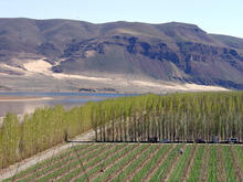
This view is of the Columbia River Gorge downstream from Interstate 90 south of Wanapum State Park. Fields of hops are planted along the floodplain (the taller hedges serve as windbreaks for the crops). Note the active and stabilized dune fields at the base of the cliffs on opposite side of the river. Dunes are a testament of the windy conditions that can prevail on the arid Columbia River Plateau.
Sources/Usage
A photo of a floodplain