
AEM survey over Kīlauea summit

Detailed Description
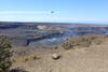
A view of the Airborne Electromagnetic and Magnetic (AEM) survey over Kaluapele—Kīlauea summit caldera—taken from Uēkahuna overlook in Hawai‘i Volcanoes National Park. The loop system below the helicopter transmits weak, low-frequency radio waves into the ground and measures the Earth response as well as passively detects variations in the Earth’s magnetic field. These variations will allow scientists to image the shallow (upper 2,000 ft) magmatic structure, fault systems, and groundwater pathways beneath Kīlauea's surface. USGS photo by K. Mulliken.
Sources/Usage
Public Domain.