
Ahuʻailāʻau GPR Survey

Detailed Description
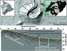
The top panel shows a shaded relief map of Ahuʻailāʻau and the locations of the survey lines in black, with the radar line below highlighted in yellow. The lower panel shows an annotated radargram, noting where the GPR saw reflective boundaries in thicker black lines. These boundaries indicate layers of basaltic pumice and other tephra that are variably continuous and inconsistently thick.
Sources/Usage
Public Domain.